The other Newhaven

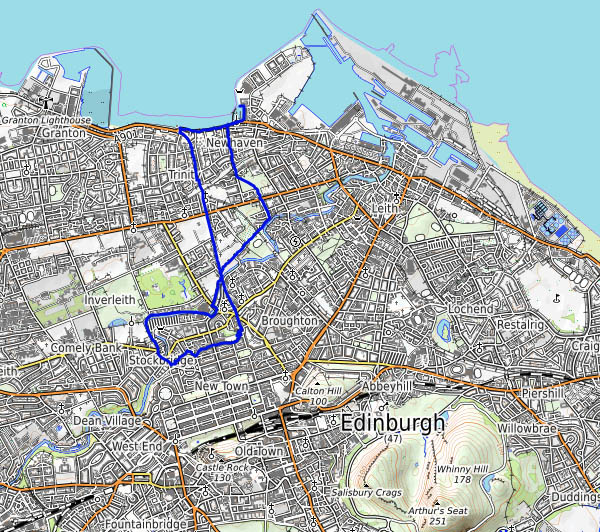
Tuesday 26 December – Boxing Day:  We’re walking from Edinburgh’s Stockbridge to the shores of the Forth at Newhaven, whose residents, I imagine, think of their south coast namesake as “the other”…. Much of the way is along well-surfaced footpaths on the trackbeds of former railways – there was quite a maze of lines between Edinburgh and Leith by the time the NBR and the Caley had finished. The buildings of the former Newhaven station, penultimate stop on the Caledonian line from Princes Street to Leith North (closed in 1962), were a pleasant surprise.

It’s a cold but clear afternoon – the low sun is bringing out the colours at the little harbour; in the distance are the shores of Fife and, away to the west, the Forth bridges. There are three of them now…

View OS map on Streetmap http://www.streetmap.co.uk/map.srf?X=325450&Y=675896&A=Y&Z=120

Dean Village

Sunday 24 December: it’s Christmas Eve, and there’s just time for a short leg stretch, before the early sunset gets the better of us. We’re in Edinburgh, and we’re taking a walk beside the Water of Leith, up through Dean Village. A detour takes through Dean cemetery, where we chance upon a familiar name – Sir Thomas Bouch, the designer of the Tay Bridge, the one which collapsed in a gale

On the last Sabbath day of 1879,
Which will be remember’d for a very long time.

McGonagall’s doggerel is worth reading, if only as an example of “how not to do poetry” (and I’m no expert! Inevitably, it rhymes (after a fashion), but McGonagall knew not scansion…)

The Tay Bridge Disaster: William McGonagall

Monkhopton Highlands

It’ll be wet underfoot – we’ll have a walk along some quiet lanes in the high ground south of Monkhopton. It’s not especially scenic, but it’s easy walking, and there are some fairly extensive views. By the time we’ve completed about 2/3 of the route, the gaps between the clouds have gone, and with them the light for photography, though it’s only just 4pm when we get back to the car. This time next month, the nights will be getting lighter again.

View OS map on Streetmap http://www.streetmap.co.uk/map.srf?X=363415&Y=292071&A=Y&Z=120

Cold Clee

Friday 24 November: It’s cold up here today – the frost is lingering in the hollows – but the sunshine (wall-to-wall!) is warm, and a picnic lunch on the rocks near the summit of Clee Burf will be just the thing. We’ve got to get there first, and we’re trying a new route, up the edge of the access land near Stoke Enclosure. It’s a good route too – until we reach the summit plateau. We have to cross deeply tussocky grassland, and there’s no path – and the gaps between the tussocks are very wet… Lunch over, we’re not going to hang around – it’s too cold, but not too cold for a chocolate stop at the well-placed wooden seat. It’s downhill from here…

View OS map on Streetmap http://www.streetmap.co.uk/map.srf?X=358635&Y=284841&A=Y&Z=120

A Willey circuit

We’re circling the Willey estate (have to circle it – can’t go through it. Private. Keep out) on a fine, still November afternoon. There’s some bright sunshine early on, lighting the remaining leaves and the odd bit of bracken. Later, as we pass the medieval old hall and head up through the woods, the sun is dimming, and we’re into the gloom of late afternoon.

View OS map on Streetmap http://www.streetmap.co.uk/map.srf?X=366255&Y=299041&A=Y&Z=120