It’s cold and sunny – and there’s a chilly breeze, though we’ll mostly be sheltered from the wind at Attingham. The snowdrops are fully out, and the walk around the perimeter of the park (about 4 miles) is about right for this afternoon.


It’s cold and sunny – and there’s a chilly breeze, though we’ll mostly be sheltered from the wind at Attingham. The snowdrops are fully out, and the walk around the perimeter of the park (about 4 miles) is about right for this afternoon.
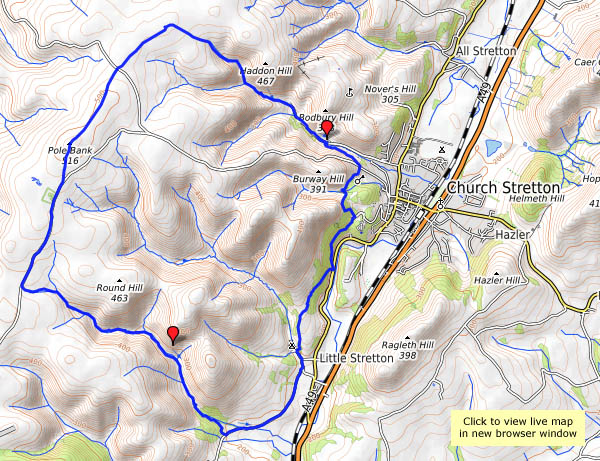
Monday 12 Feb: The wind felt stronger (and colder) and there was more cloud than the forecast had suggested, but it was still a good day (sandwiched between some pretty awful days) for an outing. We thought there might have been some shelter in Callow Hollow – and there was, beside the little Oakleymill waterfall, sufficient for a lunch break. The flurry of snowflakes waited until we were moving again – then, as we reached the summit plateau, the sky cleared, and suddenly the world was colourful once more. Given good weather, the top of the Mynd is a great place to be.


 View OS map on Streetmap http://www.streetmap.co.uk/map.srf?X=343480&Y=292591&A=Y&Z=120
It’s cold this afternoon – I need a leg-stretch, but I’ll need to be well wrapped up. Perhaps the bridge at Ironbridge was cold too – it’s certainly well wrapped. I’m wondering if there might be signs of spring, but other than the bulbs coming up in the garden, the only spring I’ll see today is the ochreous flow by the iron bowl sculptures near the river bank. There’s iron in these hills – which is why the wrapped-up bridge is here…
Project Iron Bridge – English Heritage


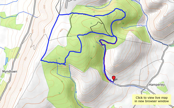
The Ordnance Survey – and almost everyone else, I suspect – calls it Priors Holt. It’s barely a hamlet, just a couple of houses nestled at the foot of Nut Batch, one of the lesser valleys on the eastern side of the Long Mynd. However, Malcolm Saville seems to have had the place in mind when he wrote his “Witchend” children’s series, so that’s how we’ll think of it. Whatever the name, it’s a quiet spot, despite its popularity with muddy cyclists (we must have seen at least six of them), and the gentle slopes of the forestry roads (ideal for the bikers) make for an easy walk to the Mynd’s summit plateau. The trees are also good shelter from the wind… The forecast said “dry, bright and windy” – it was accurate, though we arrived a little early for its first two elements. By the time we were on the Port Way, walking south along the western edge of the Mynd, the “dry and bright” had arrived, providing us with some dramatic lighting for the extensive views of the border hill country.


View OS map on Streetmap http://www.streetmap.co.uk/map.srf?X=340845&Y=290136&A=Y&Z=120
Friday 26 January: An easy stroll around Attingham Park, which became longer than intended. As we wandered through the snowdrops, we could see a wide spill of flood water where the Tern normally makes its well-behaved way through the grounds. If we walk back towards the house on the path beside the river, we can then cross over and walk up the other side. The result is (some of) the photographs below and the strange route shown on the map.
The inhabitants of the deer park wander about in stately fashion, posing for photographs until I lift the camera. Beside the house, the fine stand of cedars has taken a battering. The wind? Surely not! As we guessed, the highest branches, lying in broken disarray beneath the trees, were snapped off by December’s (literally) heavy snowfall. What a shame!

")


View OS map on Streetmap http://www.streetmap.co.uk/map.srf?X=355137&Y=310421&A=Y&Z=115
The weather’s disgusting – the morning’s snow has turned to rain. It’s grey, dull and cold, certainly not a day for outdoor activities. The tile museum at Jackfield is a pretty good standby on such days – warm, dry, and full of colour.
Jackfield Tile Museum – Ironbridge Gorge Museums


Photo footnote: It’s dark in here, not ideal for photography. Most of the pictures were taken on my D90, mostly at f:1.8, and at high to very high ISO speeds. At the other end of the spectrum, several of the close-ups were taken on a smartphone, its camera set (in “Pro” mode) to ISO 100, then placed flat on the glass of the display cabinets. The quality of these tiny cameras is amazing!
A short walk on a bright afternoon – the morning’s mist is clearing, and the sun is coming through in fits and starts. At times it’s like a searchlight, then it’s altogether softer, casting pastel shades in the distant views. These winter days can be so much more colourful than high summer!


View OS map on Streetmap http://www.streetmap.co.uk/map.srf?X=347745&Y=293476&A=Y&Z=120
It’s not all “stroll” – there’s a steep pull up Mott’s Road to the Long Mynd plateau, and our legs haven’t had enough exercise during the past few weeks. But once we’re up, it’s a very pleasant amble. The sunshine is bright, the sky is (mostly) blue, the breeze is light – no need to hurry. It’s one of those afternoons whose only downside is the need to come down…


 View OS map on Streetmap http://www.streetmap.co.uk/map.srf?X=343445&Y=294706&A=Y&Z=120
Cothercott’s decaying early 20th century concrete is hardly the prettiest relic of mining in the Shropshire hills. If the barytes mining had begun earlier, the remains might at least have been of stonework. The grim slab beside the road on Cothercott Hill has formed a minor landmark for many years, but now the site has been tidied up, with interpretation boards and a yellow-painted mines tub (from Gwynfynydd – it’s not a local!) set on a plinth as a reminder of the little railway which once operated here.
There are more interpretation boards just a little further up the hill – but we’re on our way elsewhere, and it’s bitterly cold despite the sunshine. We’ll come back another day, and perhaps try to follow the route of the railway back to the mines.


A step back in time on New Year’s Day – a short wander around Stourport. We drove there under a clear blue sky and bright sunshine, but the sun disappeared behind the clouds as we left the car. Inevitably, our drive home was mostly in sunshine. Even under a cloudy sky, there’s plenty of colour here, in the paintwork of the narrowboats in the basin, and the bright lights of the fairground next door.
Happy New Year!


")
")
")
")


