Westhope and Diddlebury Common

I’m reliably informed that it’s pronounced “Delbury” (as in the nearby Delbury Hall). This was a very pleasant four-mile wander around Westhope, the most south-westerly “hope” on the Wenlock Edge. The woodlands are increasingly autumnal; the paths through the fields are not always obvious or well-marked (potato fields are not easy to cross). Westhope itself is a quiet hamlet; its college offers craft courses, of which there’s evidence on the wall, and its teas would be splendid, I’m sure, if this was high summer and the rooms were open. The nearby pigs are entertaining…


Chapel Lawn and Caer Caradoc

Most Salopians will know of Caer Caradoc – the hill near Church Stretton with the eponymous hill fort atop its summit. Few will be aware that there is another hill fort bearing the name Caer Caradoc, in the far south-west of the county, less than two miles from the Welsh border near Knighton. Undoubtedly less well known, it is by far the more impressive. High above the delightful hamlet of Chapel Lawn, in the Redlake valley, its earthen ramparts are steep and high. Many years have passed since the Iron Age, but those defences would still be effective today.

It’s a super viewpoint too – those ancient warriors would have had a clear view of potential aggressors long before they arrived – a great place to be on this unseasonably pleasant afternoon. Chapel Lawn is a good starting place – walkers are welcome to park in the village hall car park, according to the village website, and the eggs from the community produce stall (honesty box) look as though they are truly free-range (haven’t tried them yet).

Coalport and the jungle

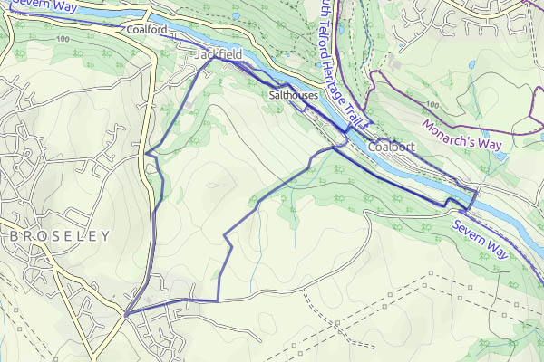
We walked down to the Severn, using paths through the woodland where possible, then along past Craven Dunnills and the site of the land stabilisation work. It’s a mess at present, but no doubt, once the work is complete, the vegetation will soon grow up again. There’s a cup of tea and a cake in the café at Maw’s, before we cross the memorial footbridge and walk beside the canal, then up to the old Coalport railway track to take us to Coalport bridge. Back on the south side, we follow the old Severn Valley railway trackbed.

We’d intended to walk back to Coalport and up the dingle (that’s the route indicated on the map below) but, just a little way before we would leave the railway route, there’s an entry into the woodland to our left, and a sign to the effect that walkers are welcome to wander in the woods. Perhaps we can take a shortcut through to the top of the dingle? The path is clear at first, but gradually fades, until we’re picking our way through dense undergrowth and following nothing more than a sense of direction. An animal started in the woodland below – the size of a large sheep. but it wasn’t a sheep. A muntjac? Gone before we had a clear view.

We found our way out, further down the dingle than I’d expected. An interesting exploration; not a short cut…

Route

A Wilderhope Walk

We’ve done it before, more then once – from the end of the surfaced lane up onto the edge, then south-eastwards along the crest to the point where it peters out, almost at the main road. There’s a red kite quartering Corvedale, gradually working its way southwards and out of sight. The return route follows the stream, barely a trickle today, before tending away to its west and up to the manor house, where there’s tea and coffee, but we’re too late for the cakes – they’re all gone. A Twix will suffice – it’s not far back to the car.

Walking from Wenlock

There’s a regular bus service from Broseley to Much Wenlock – that’s one every two hours, from 9.30 am  to 3.30 pm (ish). So today’s outing requires a little planning – it’s not wise to just turn up at the bus stop and hope  – might be a long wait. The 1.30 (ish – it was late) gets us to Wenlock just before 2.00 – that’s a good time for the walk to Benthall Hall, which is open four days a week – we can call in for refreshments. The autumn days are becoming hazy, but it’s sunny and pleasantly warm. It can’t last…

The reservoir and the waterfall

A gentle stroll from the NT car park in Cardingmill valley – up to and around the reservoir, then to the Lightspout waterfall by the high level path. Iron pipes, visible in places along the route, suggest that the path dates from the construction of the reservoir, the pipes feeding extra water from the Lightspout Hollow. We climb up beside the waterfall (there are steps…) and onto the moorland beyond. Descending Mott’s Road brings us to the pavilion in nice time for tea and cake…

Middlehope

Three dales accompany the Wenlock Edge – Corve Dale, to the south-east, is named after its river; Ape Dale to the north-west has its brooks, but is more a natural gap between the edge and other hills than a valley as such. Hope Dale lies in the middle, between the twin escarpments of the edge. In Hope Dale, towards Wenlock, there’s the hamlet of Easthope. Westhope is further to the (south) west, oddly enough. And in the middle (of the middle) is Middlehope. It’s not very big, but surely it’s better to travel and to live in (Middle?) hope? (Enough!)

This was a pleasant walk on a pleasant afternoon. The farmers are getting their crops in, making the most of the dry weather. The colours are beginning to look autumnal, there are blackberries and fungi everywhere (and one sweet, juicy damson).  It’s almost a shame to arrive back at the car, to travel hopefully towards home.

Blackpool to High Vinnals

– a walk in the forest

The Blackpool (or Black Pool, interchangeable if the waymarkers are to be believed) in question is a mile or two south of Ludlow, just past the village of Overton on the Richard’s Castle road. We’ve walked to High Vinnals before, always from the other side (see High Vinnals and the pop-up tea rooms). Time for a change!

It’s an easy ascent, at first through extensive forest, though the paths are pleasant enough. The landscape opens up a little at Climbing Jack Common, and the views from High Vinnals would be tremendous, if it wasn’t for all the trees… There are gaps to the west, and to the east, the trees are still small. A little west of south, looking along the ridge, we can see the Black Mountains, and further west, Pen-y-Fan is just visible through the haze, some 40-odd miles away.

We’re heading back towards the car now, mostly along forestry tracks, with the odd stretch of footpath cutting through the necks of some of the loops. There’s just a little blue butterfly flitting about in the heather, and a friendly frog, to delay our return.

Down the coast – Borth to Aber

Aberystwyth was always “Aber” on the railway – as a chalked destination on a parcels van perhaps. We’d be travelling by rail today, for a leisurely stroll along the cliff-top path from Borth to the university town.

The rain that started minutes after our arrival in Borth accompanied us to the top of the headland; a little way beyond it eased, and we were soon able to pack away the waterproofs and enjoy the coastal scenery. The cliffs are not high, but there is plenty of interest along the route, not least in the stripy strata clearly visible in the rocks.

The shingle spit at Wallog,  “Sarn Gynfelyn”, is one of several similar features of the coast. Of man-made appearance, they are the stuff of myth and legend – ancient ways to submerged kingdoms.

Clarach Bay is full of caravans and chalets. It’s not the prettiest part of the walk, and we pass through quickly – but a little way beyond, back on the cliff path, there’s a picnic bench. It provides a quiet spot for a break and a late lunch before we arrive at Aber, to walk along the promenade and enjoy a well-earned ice-cream (“Mario’s” – excellent!)

“Aber” is perhaps a touch ambiguous, and appropriately so. The full name means “mouth of the Ystwyth” – but that river makes a rather inconspicuous approach to the town, sneaking into the Rheidol just yards from the open sea. It’s the latter that is more obvious, providing the harbour for numerous pleasure craft – and, as we waited on the station platform, a Vale of Rheidol train steamed gently into the former Carmarthen line platforms. Aberrheidol perhaps? If nothing else, it would be easier to spell for us poor pob sais.