Summer fields

Weds. 3 July: a short wander from Benthall Hall. There’s lots of colour in the fields and hedgerows, and later, it’s pleasantly cool under the trees of Benthall Edge, with views down to the doomed cooling towers, and Ironbridge. Back at the hall, the ice creams are perfect, though I’m not sure we’ve really earned them.

View OS map on Streetmap http://www.streetmap.co.uk/map.srf?X=365650&Y=302706&A=Y&Z=120

Walking from Bedlam

It’s a handy place to leave the car! Too warm for energetic walks up hills – best to stay under the trees where possible, even if there aren’t many photo opportunities. If we walk downstream on the north bank, we can return to Ironbridge  on the south bank, along the old railway track – and we’ll have earned an ice cream by the time we’re there. Refreshments disposed of, it’s a short walk back to Bedlam, and we can do most of it away from the road.

View OS map on Streetmap http://www.streetmap.co.uk/map.srf?X=368940&Y=302726&A=Y&Z=120

Finding the Pyramids

A fine June afternoon – bright sunshine, white puffy clouds (and the chance of a shower? No, surely not?). It’s a sausage-shaped walk, where our outward route, below the crest of the Wenlock Edge, is only 100 yards or so from our return – but also lower by a similar extent. The path through the trees is very pleasant, with the sun at our backs, but the return along the ridge is more open – and here are the pyramids! They’re orchids, dozens of them, scattered here and there in the dry grass beside the path. With plentiful pink and white wild rose, honeysuckle and (as we used to call them) “dog daisies”, it’s a colourful part of the world.

View OS map on Streetmap http://www.streetmap.co.uk/map.srf?X=359215&Y=298296&A=Y&Z=120

On the Chase in June

We’re heading for Cannock Chase – the weather forecast says it should stay dry (it did), while showers would affect western Shropshire in the afternoon (they did). It’s not a great day, photographically – the clouds are heavy and ominous, and there’s no real sunshine – but it’s very enjoyable to explore the heathland, which varies in appearance and feel as we make our way around. A fairly long one today – just short of 10 miles – so we’ve earned our tea and cake at the visitor centre…

View OS map on Streetmap http://www.streetmap.co.uk/map.srf?X=399085&Y=317611&A=Y&Z=120

Bears and the Mynd

If you go down to the woods today, you’re sure of a big surprise…

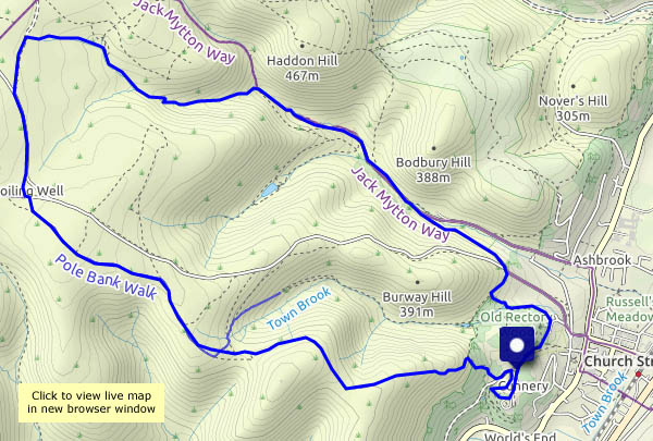
That may be true, for the unsuspecting, but I must admit that I’d hoped we might find them… They’re in the trees beside the Long Mynd Hotel, and rather fine they are too. We’re taking a walk on the Mynd, from a different starting point – the little car park at the top of Cunnery Road, and making a small ursine detour before tackling the steep path up the Ashlet hillside. We’ll walk towards the Boiling Well, before cutting across to the top of the Light Spout valley, to return to the start past the waterfall, down the Carding Mill valley and through Rectory Woods. A very pleasant outing, perfect for this cold (is this really June?), windy but dry afternoon.

View OS map on Streetmap http://www.streetmap.co.uk/map.srf?X=343480&Y=294411&A=Y&Z=120

Wenlock to Perkley

An easy wander to the south-west of Wenlock, on the last day of (meteorological) spring. There are wild flower meadows, fields of wheat, barley, oats and potatoes (and oilseed rape, almost completely faded), and hidden ways between lines of trees. Other than the power station chimney and cooling towers (not for much longer) it’s a rural and unspoiled landscape.

View OD map on Streetmap http://www.streetmap.co.uk/map.srf?X=361430&Y=298891&A=Y&Z=120

The Bannister’s Round

It’s become a favourite – a very enjoyable circular route from Much Wenlock, down through Traps Coppice and into Bannister’s Coppice, then beside Sheinton Brook and back up through Homer. There was a chance of rain earlier in the afternoon – this route is mostly in attractive woodland, but in the event we didn’t need shelter. By the time we’d topped the edge above Homer, the day had changed for the better.

View OS map on Streetmap http://streetmap.co.uk/map.srf?X=362175&Y=301916&A=Y&Z=120

Topley and The Speller

Another afternoon that’s too good to waste… We’re starting at the top of the Rushbury to Beambridge road, where it crests the Wenlock Edge, and walking around the rotund hill at Topley, along quiet farm lanes and tracks. Our return takes us through Upper Millichope and intriguingly-named “The Speller”, just one part of more extensive woodlands hereabout. It’s attractive country too – walking uphill, back towards the edge, we’re in deciduous territory, where the sunshine dapples the undergrowth. Lastly, buttercup meadows lead us to the track along the edge, back to the start.

View OS map on Streetmap http://www.streetmap.co.uk/map.srf?X=352060&Y=289946&A=Y&Z=120