Looks like rain…

There could be one or two showers this afternoon, the forecast suggested. The clouds were dropping unsubtle hints too. We’d better not stray too far, and preferably somewhere where there might be shelter. We’ll walk down to Coalport – if it rains, we can enjoy our tea and cakes indoors. A few drops began to fall as we approached the old railway bridge at the bottom of the lane – ten minutes later, it had cleared and we were on our way again.  Fed and watered at the YHA cafe, we’re heading back up the dingle, where the wild garlic is still flowering, and to those with a sense of smell, making its presence known…

Hilbre Islands

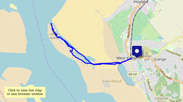
Not as exotic as they sound, these low tidal islands are in the mouth of the Dee estuary. The closest, “Little Eye” (which, I suspect, translates appropriately as “little island”) is barely a kilometre distant from the ice-cream stall at West Kirby. That kilometre is a major obstacle when the tide’s in, but a couple of hours after high tide, the sands (and muds – we brought some home with us…) here are walkable, in waterproof footwear or bare feet. Once there, we’re in a very different world – more than ever, I’m conscious that the photographs may convey the appearance of this little archipelago, but not the feel of being there.

From Little Eye, we make our way to Little Hilbre, where there’s a good spot to sit for a few minutes and enjoy our lunch, before continuing to Hilbre Island itself. The rock formations are wonderful, and there’s a blaze of colour in the abundant thrift (“sea pink”, my companion calls it) and other plant life. At the north end of Hilbre is a deserted lifeboat station, and beyond that, open water. Seals peer up, waiting to reclaim their rocks when the visitors leave. That’s all that’s left for us to do – apart from the aforementioned ice creams, of course. What a great little expedition this has been!

The Friends of Hilbre

View OS map on Streetmap http://www.streetmap.co.uk/map.srf?X=319560&Y=387436&A=Y&Z=120

Chestnut Coppice and Colemore Green

Bank Holiday Monday (again!) – we could use some fresh air, but we’ll need to avoid the hot spots… It should be quiet down by the river near Colemore Green. It was, too – apart from the inevitable cyclists on the old railway track (and the fishermen at the pools) there was no-one else around. It’s another dull grey day, and cold – some sunshine would have given the photos a bit more sparkle, but at least it’s stayed dry.

View OS map on Streetmap http://www.streetmap.co.uk/map.srf?X=371090&Y=297326&A=Y&Z=120

Cast not a clout…

…or is it “Ne’er cast a clout”? Either way,  don’t do it “till May be out”. Does the old saying relate to the May blossom – which is out – or the month? It’s certainly too cold at present to cast any clouts – but at least it’s stayed dry, and with light winds, it’s very pleasant up here on the Edge near Much Wenlock.

View OS map on Streetmap http://www.streetmap.co.uk/map.srf?X=361955&Y=300376&A=Y&Z=120

The far north

Rubha Hunish: the northernmost tip of Skye. We could see it yesterday, over to the west. It’s a fine morning, and if I get there soon, I should be able to park the car without trouble. Without a doubt, it’s the only way to beat the hordes. The walk to the cliff tops (Meall Tuath and Meall Deas) overlooking the Hunish peninsula is becoming popular, but not all visitors are prepared to take the precipitous route down the cliff face. The peninsula itself is wonderful – gentle grassy slopes 50′ – 100′ above the sea, with superb coastal architecture along the east side – stacks, an arch – fine views and the sound of nesting seabirds. The views, admittedly, could be clearer – it’s been hazy all week, and we’ve barely seen the outer isles. But it’s great here – just me, the gulls, a few gannets, cormorants and – was that a golden eagle?

As I approach the cliffs for the scramble back up, there are one or two figures on the headland, by the bothy, and as I make my way back along the path, I meet an eclectic cross-section of humanity. Some respond to my greeting; others look straight through me. Did I fall off the cliff and perish? Am I a ghost?

View OS map on Streetmap http://www.streetmap.co.uk/map.srf?X=141529&Y=875608&A=Y&Z=120