Is this a grey day?

Seems to be. I’ll go for b&w. Inevitably, and despite the forecast, the sun decides to shine (for a while), and the camera switches itself to colour mode. Perhaps it’s trying to tell me something? For the purpose of these pictures, I’ll stick with plan A. It’s Ironbridge and Coalbrookdale, staying with the quieter, less-frequented ways.

There’s no-one here!

We’ve had lunch, the rain has stopped and the sky has cleared, so we’re taking a stroll from Ironbridge to the top of Coalbrookdale and back. It’s a pleasant afternoon – mild, bright and mostly dry (it’s trying to rain when we get back to the car). But where are all the people? There’s no-one else on the bridge, the Wharfage is deserted, Coalbrookdale’s quiet. Most unusual!

View OS map on Streetmap https://www.streetmap.co.uk/map.srf?X=366895&Y=304151&A=Y&Z=120

A Castle in Coalbrookdale

No. 7029 “Clun Castle” was in action today, on a couple of shuttles between Wellington and Coalbrookdale. It was advertised as the last steam to (or was it “from”?) Ironbridge – but that was over 50 years ago. We’re not complaining – it’s good to see a train of any kind on the line which used to serve the now-defunct power station. It was very dull for the first run, but the sun did its best for the second. Here’s a sample – more to come on “Geoff’s Rail Diaries“…

Rails and pools

Wednesday 27 Feb: We’re enjoying the last day of the warm sunny spell, walking from the top of Coalbrookdale to the pools at Dawley, in part following the route of old pre-railway age wagonways. We’ll cross (on public footpaths) some real railways too – the disused line to the power station and the soon-to-be-reconstructed line from Horsehay. The various pools, dating from the same era as the wagonways, are likewise associated with the early iron-making industry in these parts. They look pleasantly rural in the bright sunshine.

View OS map on Streetmap http://www.streetmap.co.uk/map.srf?X=367790&Y=305706&A=Y&Z=120

Loamhole Dingle

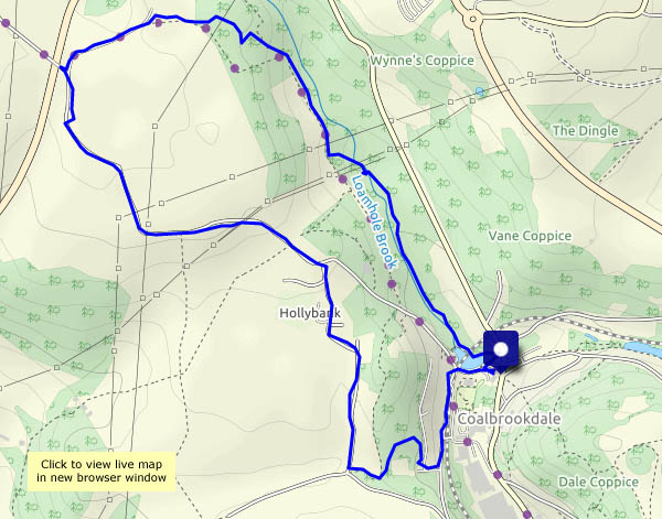
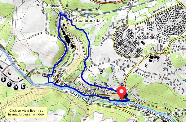
A short walk from the “coke hearth” at the top of Coalbrookdale. Like several others in this area, the dingle is a steep-sided little valley whose stream feeds the Severn. Below the coke hearth, it’s mostly culverted – higher up, it’s a jungle waterway. The path – a board-walk for much of its length – follows the stream fairly closely – away from the path, much of the woodland looks impenetrable (we’re not going to try!).

Our return takes us through Sunniside – and just beyond, there on the skyline are the most unlikely creatures – alpacas, ostriches (emus?) and reindeer. Are we still in Shropshire?

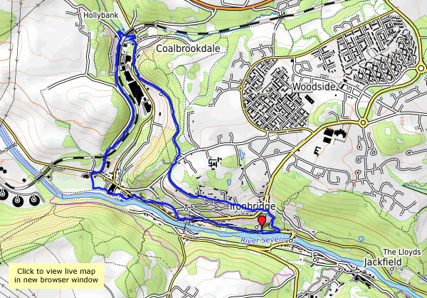
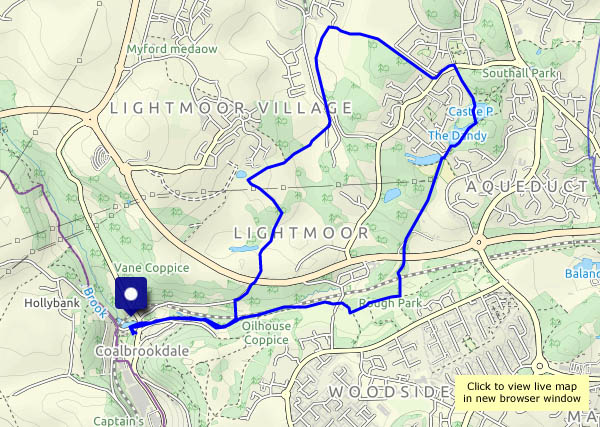
View OS map on Streetmap http://www.streetmap.co.uk/map.srf?X=366217&Y=305081&A=Y&Z=115

Up the dale

Saturday 17 Feb: It was cold, but clearly it was sunny too – just a day later, before looking through the photos, I’d remembered the weather being dull. Memory plays tricks! We’re walking in the Ironbridge area, following mostly quiet roads away from the Wharfage, which is always busy. There’s always something to catch the eye in this part of Shropshire.

View OS map on Streetmap http://www.streetmap.co.uk/map.srf?X=367260&Y=304311&A=Y&Z=120

Bedlam to Coalbrookdale

The remains of the ancient iron furnaces at Bedlam were open to the elements until very recently – now they have a cover – a canopy with substantial steel supports. We’d better take a look. Afterwards, we’ll wander over the hill, and down Church Road, viewing the closed power station through the trees (there’s a common theme to this little walk…). At the top end of Coalbrookdale the viaduct no longer serves its purpose. The woodland path to the old railway station, now in the care of the Green Wood Centre, overlooks the iron works, soon to cease production. It’s been a quiet walk so far, but now we’re dodging the many visitors to Ironbridge as we walk beside the river back to the car. At least one thing is still thriving here.

View OS map on Streetmap http://www.streetmap.co.uk/map.srf?X=367367&Y=304093&A=Y&Z=120