Hope Dale

We’re out on the Wenlock Edge, on a beautiful July afternoon. The air is fresh after overnight rain, there’s a pleasant breeze, and plenty of sunshine. We start from the small car park at Harton Hollow, and follow the lane via Middlehope to Wetmore Farm. There are hundreds of butterflies, of several varieties, but none of them are willing to pose for the camera. And there’s a peacock! It’s not the most scenic of walks to Wetmore – the hedges are ten or twelve feet high, though there are views from the occasional field gate. From Wetmore, we head on up to the edge path – at first, it skirts the woodland, and there’s a good view down into the dale and beyond. Then we’re amongst the trees – very pleasant open deciduous woodland, with a good path along the crest of the Wenlock Edge to take us back to the car.

Map

View OS map on Streetmap http://www.streetmap.co.uk/map.srf?X=349460&Y=288786&A=Y&Z=120

Where East meets West

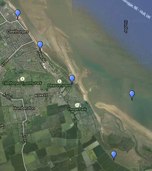
Cleethorpes, in this case. This was a day out by rail, from Shrewsbury to Stockport, where we changed trains for Sheffield, via the Hope Valley line, and Doncaster to the terminus on the southern bank of the Humber. After a brief pause for fish and chips (obligatory), we walked south-eastwards the mile or so along the sea front to the Cleethorpes Coast Light Railway terminus. We would have caught the next train to the other end of the line at Humberston, but it was fully booked for a large party of small children, so we walked on. There’s an unexpected discovery close by Humberston station – a shiny steel plaque set in the footpath marks the Greenwich meridian – we’re crossing from the west into the east…

After a brief exploration of Humberston Fitties, we took to the sands, which eventually give way to an area of salt marsh, with all manner of coastal plant life, and randomly-arranged muddy creeks which make progress tricky. Returning to the shore path, we walked a little further to where an old pillbox provided a slightly-elevated seat for us to sit back for half-an-hour and take in the vista, across the sands to the estuary and, on the opposite shore, Spurn Head. Two curious structures catch the eye – Haile Sand and Bull Sand forts, built just 100 years ago to defend the mouth of the Humber. Numerous cargo boats move up and down on the incoming tide, while closer at hand, there’s a reed bunting in the bushes and a sparkling white egret in the pool.

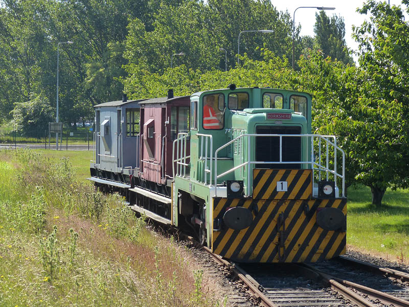
We’d walked getting on for five miles at our turning point, so the 15″ gauge light railway provided a welcome break in the long walk back to the railway station, for the journey home. But midsummer isn’t long past, and it’s only as we’re approaching Shrewsbury, where we’re due at 22.08, that it really begins to get dark. A most enjoyable day, with everything going to plan (no late trains), a real change of scene and a breath of sea air.

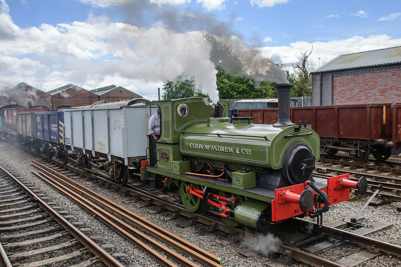
For more on the Cleethorpes Coast Light Railway visit “Cleethorpes” on Geoff’s Rail Diaries


Map

Stiperstones – foxgloves, bilberries and kites

July on the Stiperstones: we were up here around this time last year, and nearly melted. Today the sky was blue, with some white fluffy cloud – and it was pleasantly cool, a great afternoon for a walk. The bilberries need a little longer, though they’re ripening nicely. The foxgloves – great clumps of them in places – are in their prime. A red kite crossed the sky, high up, with never a flap – and returned a few minutes later, performing one large circle and then away. Too far away for the camera, but good to see.

Map

View OS map on Streetmap http://www.streetmap.co.uk/map.srf?X=336400&Y=297876&A=Y&Z=120

Ryedale Ruins

Sunday afternoon: we’re visiting Rievaulx Abbey, in the quiet valley just a couple of miles from the summer bustle of Helmsley. There’s some dark cloud around, and the chance of a shower – if we carry the brolly we won’t need it. I’d been here before, many years ago, but had forgotten just how substantial and extensive these ruins are – as were the cakes and scones at the cafe…

Rievaulx Abbey (English Heritage)

No, we didn’t need the brolly…

Large and little

Yorkshire “Janus” no 1 at Scunthorpe

It was a busy weekend – on Saturday, we were booked for a brake-van trip around Scunthorpe steel works – and we had “the works” too – a 5-hour trip around the site, taking in the main lines, branches, spurs and sidings. Great fun!

7¼" gauge NER Class C 0-6-0 no 22
7¼” gauge NER Class C 0-6-0 no 22

– and then on Sunday, we paid a brief visit to Gilling East, home of the Ryedale Society of Model Engineers. At the other end of the scale from Scunthorpe, it was fun too. We need to go again to do justice to it.

For more on both trips, visit “Appleby Frodingham” and “Gilling East” on Geoff’s Rail Diaries

Pyramids

Orchids – little conical-topped ones – dozens and dozens of them. And one solitary (greater?) butterfly orchid (they’re not common). We’re walking on Wenlock Edge, the same route we followed on a misty day in February (see “A hazy day on Wenlock Edge“). It’s virtually midsummer now – no mist today, instead there’s warm sunshine, and it’s pleasant in the cool shade under the trees.

The map below is the one used in February:
today we walked clockwise – out below the edge, back along it.

MapView OS map on Streetmap http://www.streetmap.co.uk/map.srf?X=359285&Y=298596&A=Y&Z=120

Coal Trains

Colin and the coal trucks

We’ve been to Chasewater this afternoon, for their “Coal Trains Day” event (what better way to celebrate the solstice?). Red (No 2), green (Colin McAndrew) and blue (Holly Bank No 3) steam locos in action on the self-styled “Colliery Line” – great fun! For more on the day’s activities – and more pictures – visit “Coal Trains Day” on Geoff’s Rail Diaries.

Sheinton to Harley, Wigwig and Homer

Life under the edge

There’s many a double-take by passing motorists on the Shrewsbury – Wenlock road – “Did that sign really point the way to Wigwig and Homer?”. Yes, a hamlet and a small village well-hidden, despite the sign, beneath the northern end of the Wenlock Edge. This was a very pleasant circuit, starting from Sheinton, following farm lanes and tracks past Belswardyne Hall to Harley. “Look at that – the sun’s got a halo”. There’s no need to enter quiet Harley village, and it means crossing the busy A458 twice – but it saves walking beside the noisy road. The lane to Wigwig crosses what was once a ford, and probably still is in very wet weather. In Homer, we leave the road and take to fields of sheep, followed by attractive woodland beside Sheinton brook, then more fields of sheep – and we’re back in Sheinton.

Map

View OS map on Streetmap http://www.streetmap.co.uk/map.srf?X=361005&Y=302661&A=Y&Z=120