Foggy day

At home, we’re just on the edge of it; along the Wenlock Edge, we’re well above it. It’s pretty thick down in Apedale, but we can see the Hope Bowdler hills poking out through the fog. We’ll keep going! The forecast says the clear blue above the fog will be replaced by cloud later in the day, so we’ll set off in the morning (after scraping a very hard frost from the car) and find somewhere on the hill to eat our sandwiches (the Battlestones). As we head slowly back towards the car, the day is changing. We’ve had the best of it!


map

View OS map on Streetmap http://www.streetmap.co.uk/map.srf?X=347860&Y=293626&A=Y&Z=120

Shirlett: a Christmas leg-stretch

25 December: a day when we get out, weather permitting, for a walk and a breath of fresh air. On this Christmas Day, there’s no shortage of the latter – quite a stiff breeze, though the route we’re following will be sheltered. It’s certainly not cold – 13C according to the Met Office. It’ll soon be dark though – better get back to the car, and head for home and Christmas tea (featuring, among other things, a rather fine locally hand-built pork pie). Merry Christmas everyone!

We were here (Streetmap):  http://www.streetmap.co.uk/map.srf?X=365980&Y=298106&A=Y&Z=120


Longer days ahead

22 December: We’re past the shortest day now, though it will be weeks before the evenings become noticeably lighter. It’s a fine and breezy afternoon – a last chance for a good leg stretch before the weather deteriorates and the Christmas fun begins. Brown Clee beckons!

As ever, it’s quiet up here. Just as I leave the car, two families arrive, but I’m away, and won’t see them again. Other than a solitary photographer at the highest point, I’ve got the hills to myself (and the sheep, and a couple of small groups of wild horses). The breeze stiffens at Clee Burf, the secondary summit, but it’s quiet enough at the seat above the five springs for a lunch break.

I’m off again, following a soggy path to the summit at Abdon Burf, and for a few seconds (the wind is cold here) I’m the highest person in Shropshire. I’ll return to Cockshutford down the track towards the telephone box, before taking the contouring path back to the lane. There’s a glimpse of a red kite for a few moments, but try as I might, I won’t see him again. Until the next time, perhaps…

map

View OS map on Streetmap http://www.streetmap.co.uk/map.srf?X=358625&Y=285576&A=Y&Z=120

Back to Bannister’s

We walked to Bannister’s Coppice in the autumn, on a beautiful golden day; today’s dull and colourless, but I need a leg-stretch. Perhaps, like last time, I’ll see deer? Perhaps not. If nothing else, I can check the existence of a footpath, not shown on the OS map, which will avoid muddy fields on the return leg. Yes, it’s there, winding through the trees – the views are better too, looking back along the Wenlock Edge, with the village of Homer prominent in the middle distance. By now the afternoon is getting late – the light’s gone. Time for home.

map

View OS map on Streetmap http://www.streetmap.co.uk/map.srf?X=362505&Y=302021&A=Y&Z=120

A short day out

Tram 31, Stephenson StreetThey’re all short at this time of year… Been out exploring by rail, using a “West Midlands Day Ranger”. By the time we got back to New Street, it was dark – but there’s enough light for a few photos of the trams, before squeezing into a rush-hour train. More to follow, in due course, on “Geoff’s Rail Diaries”. In the meantime, here’s tram no 31 in Stephenson Street.

North and south hills

28 November: Meall Tuath and Meall Deas are the rocky hills (or possibly “lumps”) which overlook Rubha Hunish, Skye’s northern tip. I was here in the summer, scrambling down the cliff-face to reach that grass-topped rocky tongue of land. Today, we’ll be content to take in the vista from these superb viewpoints. On Meall Tuath, there’s a former coastguard lookout, now equipped as a mountain bothy – could be a great place to spend a short midsummer night, but not in late November. Once again, we’re on our own out here – apart from the sheep and the seabirds – and golden eagles. There were two or three above us as we parked the car, gone by the time we were out – but then, as we made our way along the path, there was another. A grab shot will have to suffice for illustration – they may be big, but they’re hard to find in the viewfinder on maximum zoom, and they don’t exactly pose. A great sight on our last day out up here – soon we’ll be heading south, with fingers crossed for weather and traffic…

map

View OS map on Streetmap http://www.streetmap.co.uk/map.srf?X=141484&Y=875643&A=Y&Z=120

Quiraing

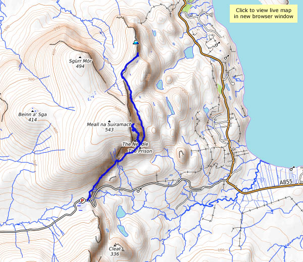
27 November: It’s one of the most spectacular landscapes in the British Isles – and the path to the Quiraing from the top of the pass, between Uig and Staffin, is one of the most enjoyable. Its popularity makes the first part of this walk difficult in summer – largely because it’s almost impossible to find anywhere to park. But on a Sunday morning at the end of November, even with such amazingly good weather, there are just six other cars. I’ll meet other walkers along the way, but it is truly quiet here today. The only sound for much of the time is that of the waves breaking on the shore at Staffin, perhaps a mile and a half distant.

The last few times I’ve walked along the path below the Quiraing, I’ve been with others who wouldn’t be persuaded to scramble up into the rocky stronghold, but today I’m alone, so it’s up the steep crumbling slope, behind the needle, through the cleft and onto the table, a remarkable small grassy  plateau completely enclosed by the crags. A couple of young walkers are here (one is a “Staffinite”, according to his companion), enjoying the photographic opportunities, but I get the impression that many, if not most, casual visitors give this part of the walk a miss.

The descent back to the contouring path is possibly more difficult than the ascent, but I’m down again, walking on towards Sròn Vourlinn (yes, we were here in August, on the path from Flodigarry) – and I discover the downside to November exploration. I knew that the early sunset would limit my time up here, but hadn’t thought about the effect of the sun’s low angle – much of the path beyond the Quiraing is in deep cold shade. It’s worth it for the additional views that open out eventually – to the north and west, where Lewis and Harris are prominent across the Minch. Can’t afford to hang about though – I’d better get back… What a great day it’s been!

map

View OS map on Streetmap http://www.streetmap.co.uk/map.srf?X=144673&Y=869436&A=Y&Z=120