The Crab

the-crabAn unusual visitor to the Severn Valley Railway this weekend –  an ex-LMS Horwich mogul (these ungainly-looking machines were universally known as “Crabs”) from the East Lancs Railway. Last time I saw one of these in steam was around 50 years ago: it was black and dirty, but somehow more real than this beautifully-restored specimen. Great to see 13065 today though!

A Rail Diaries page will appear, but not before a second attempt tomorrow – fingers crossed for some sunshine.

Grandstand

The Hope Bowdler hills are not the highest  in Shropshire, but later in the afternoon, at this time of year, they provide one of the most spectacular viewpoints for the border country. Beyond the numerous ridges, picked out in the golden light, our south-western horizon is filled by the broad table of Radnor Forest. We have to feel sorry for all the others – those who weren’t up there. We only saw three people, and one of them, a runner, didn’t really seem to be paying much attention (What is this life if, full of care…). There are one or two showers about; happily, they pass us by. It’s not all good – there’s a biting breeze, and the temperature is dropping quickly as the sun nears the horizon. We’re almost glad to get back to the car.

opentopomap

View OS map on Streetmap http://www.streetmap.co.uk/map.srf?X=347585&Y=293626&A=Y&Z=120

To Fairoak Pools

Early November in Staffordshire: it’s cold but it’s sunny, and there’s little wind – Cannock Chase could be good, we can have bacon rolls* for lunch at the visitor centre… We’re ringing the changes slightly – starting from one of our usual spots, we’re taking in a detour to Fairoak Pools – they look good on the map, and we can loop around them. They’re man-made – dammed, in other words – but they’re very attractive in the sunshine, the autumn leaves of birches and oaks contrasting with the dark pine forests beyond. After lunch, tall beeches glow beside the track as we head back towards the car; in the last half-mile, we look out past silver birch trunks to the grassy plateau beyond. “There could be lions” says my wife, just as the word “savanna” pops into my mind.

* We were too late. They don’t serve breakfast items after 1pm. (Have they been raided by the diet police?) The wraps and rolls, it has to be said, were pretty good, but not the same…

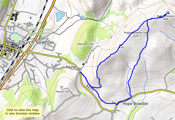
View OS map on Streetmap http://www.streetmap.co.uk/map.srf?X=399385&Y=316326&A=Y&Z=120
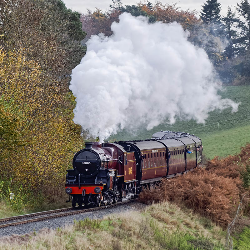
Oh deer!

Wenlock to Bannister’s Coppice – out via Homer, back past Farley Hill and along the old railway track. The morning’s fog has cleared to hazy sunshine – it’s an afternoon to be out and about. The air is almost still, and though the woodlands are carpeted with the fallen, the trees are still well-covered with leaves, in widely varying shades of red and gold. There are usually deer about in these woods – today we enjoy no fewer than five sightings. In Bannister’s Coppice there are two, then two more, then a family of five, then a group of perhaps ten, out from the edge of the wood, tempted by the turnips in the field. Later, another two trot away from us on Farley Hill. These fallow deer are shy, often only partly visible for brief moments through the trees (and almost impossible to photograph). The turnip thieves are a real bonus, making this last day of October a little bit special.

View OS map on Streetmap http://www.streetmap.co.uk/map.srf?X=362115&Y=302131&A=Y&Z=120

Stiperstones in October

We’re walking the length of the ridge, from Snailbeach to the Rock, on a fine autumn day with the promise of some sunshine. The starting point is significant – one of our objectives is the Bog Centre for tea and cake – if we’d started there, it might have been closed by the time we returned (and that would never do!). So we’re heading out past Lordshill chapel and the Hollies, and two-thirds of the way around this very enjoyable route we come to the Bog, feeling suitably peckish. We return by the paths skirting Perkins Beach and Crowsnest Dingle, back to Snailbeach past that very fine octagonal chimney high up in the woods. And yes, after a dull start, the sun did shine, though it looked like we’d seen the last of it when we arrived back in Snailbeach. We hadn’t, of course – inevitably, it shone brightly while we drove home, floodlighting the autumn trees against a dark sky. Wonderful – but no photos.

View OS map on Streetmap http://www.streetmap.co.uk/idld.srf?X=336585&Y=299306&A=Y&Z=120&lm=1

Gogbatch and the pond

It’s cold on the Mynd this afternoon – the wind’s in the north-east, biting after a few spots of rain. We’re walking from Gogbatch up to the pond on the Portway, a very pleasant and easy ascent. The forecast had suggested brighter conditions, which we begin to enjoy after the first mile or so. The sun’s low in the sky now – the clocks will soon be going back – and it’s dropping noticeably as the afternoon progresses. The light is everything it wasn’t during the summer months – warm in colour and directional, picking out the detail in the landscape like a spotlight. Weather permitting – and today it did – this is a great time to be out on the hills.


View OS map on Streetmap http://www.streetmap.co.uk/map.srf?X=344442&Y=296456&A=Y&Z=120

Old ways

We’ve parked at Bedlam, beside the old furnaces (I wonder how they got that name…). Our route takes us up the hill towards Madeley, where we’ll walk around three sides of the old (closed in 1920) Meadow pit mound. On and off, we’re following the trackbeds of the pre-railway age tramways of the Madeley Wood Company – as far as the All Nations (a last remnant of times long before “craft beer”, when pubs brewed their own beer). Now we’re walking down the route of the Coalport branch railway, which closed to passengers more than 60 years ago. Descending to the canal, at the foot of the Hay Incline, we cross the river to Jackfield, and for the first time walk the new path through the stabilisation works. Beyond, we’ll walk where Severn valley railway trains once ran – before crossing the Severn again on the modernistic new “Free Bridge” to return to the car.

View OS map on Streetmap http://www.streetmap.co.uk/map.srf?X=368575&Y=303426&A=Y&Z=120