What a contrast there is in the styles of these buildings, in this very quiet (and very cold – we’re not hanging around!) Welsh border town, formerly county town of Radnorshire.


What a contrast there is in the styles of these buildings, in this very quiet (and very cold – we’re not hanging around!) Welsh border town, formerly county town of Radnorshire.
They were an unexpected bonus – we hadn’t realised the hostel cafe was open, and despite the cold, there was enough sunshine and shelter for us to sit outside. Other than the café, a couple of lambs and some catkins, there are few signs of spring. We’ve got some cold weather to get through before things warm up.


View OS map on Streetmap http://www.streetmap.co.uk/map.srf?X=369350&Y=301556&A=Y&Z=120
So they say! It’s cold, with an easterly breeze – but it’s sunny and dry, and we won’t feel the cold if we keep moving. Just a short leg-stretch, roughly half-way between Much Wenlock and Broseley, from Barrow to Wyke and back.


 View OS map on Streetmap http://www.streetmap.co.uk/map.srf?X=365200&Y=301131&A=Y&Z=120
A wander around Ludlow on a sunny (but cold and breezy) afternoon – down to Dinham weir via Linney, then along the riverside path to Ludford, and back up Broad Street. The cheese shop is calling…


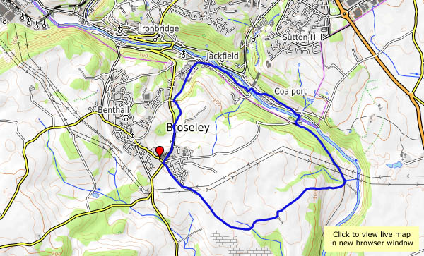
Saturday 17 Feb: It was cold, but clearly it was sunny too – just a day later, before looking through the photos, I’d remembered the weather being dull. Memory plays tricks! We’re walking in the Ironbridge area, following mostly quiet roads away from the Wharfage, which is always busy. There’s always something to catch the eye in this part of Shropshire.
")


View OS map on Streetmap http://www.streetmap.co.uk/map.srf?X=367260&Y=304311&A=Y&Z=120
It’s cold and sunny – and there’s a chilly breeze, though we’ll mostly be sheltered from the wind at Attingham. The snowdrops are fully out, and the walk around the perimeter of the park (about 4 miles) is about right for this afternoon.


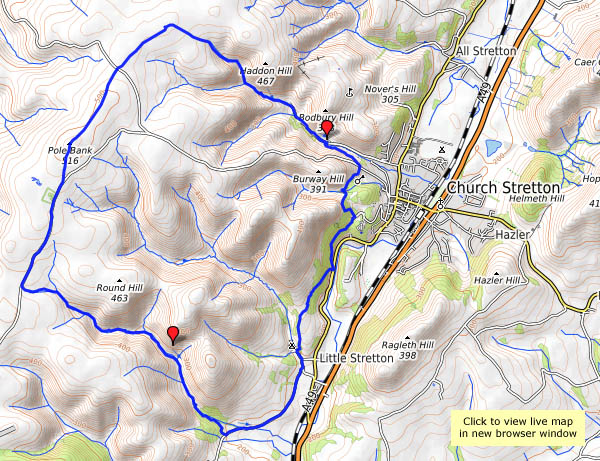
Monday 12 Feb: The wind felt stronger (and colder) and there was more cloud than the forecast had suggested, but it was still a good day (sandwiched between some pretty awful days) for an outing. We thought there might have been some shelter in Callow Hollow – and there was, beside the little Oakleymill waterfall, sufficient for a lunch break. The flurry of snowflakes waited until we were moving again – then, as we reached the summit plateau, the sky cleared, and suddenly the world was colourful once more. Given good weather, the top of the Mynd is a great place to be.


 View OS map on Streetmap http://www.streetmap.co.uk/map.srf?X=343480&Y=292591&A=Y&Z=120
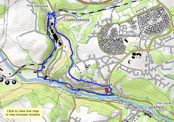
It’s cold this afternoon – I need a leg-stretch, but I’ll need to be well wrapped up. Perhaps the bridge at Ironbridge was cold too – it’s certainly well wrapped. I’m wondering if there might be signs of spring, but other than the bulbs coming up in the garden, the only spring I’ll see today is the ochreous flow by the iron bowl sculptures near the river bank. There’s iron in these hills – which is why the wrapped-up bridge is here…
Project Iron Bridge – English Heritage


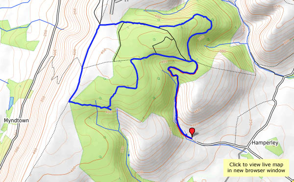
The Ordnance Survey – and almost everyone else, I suspect – calls it Priors Holt. It’s barely a hamlet, just a couple of houses nestled at the foot of Nut Batch, one of the lesser valleys on the eastern side of the Long Mynd. However, Malcolm Saville seems to have had the place in mind when he wrote his “Witchend” children’s series, so that’s how we’ll think of it. Whatever the name, it’s a quiet spot, despite its popularity with muddy cyclists (we must have seen at least six of them), and the gentle slopes of the forestry roads (ideal for the bikers) make for an easy walk to the Mynd’s summit plateau. The trees are also good shelter from the wind… The forecast said “dry, bright and windy” – it was accurate, though we arrived a little early for its first two elements. By the time we were on the Port Way, walking south along the western edge of the Mynd, the “dry and bright” had arrived, providing us with some dramatic lighting for the extensive views of the border hill country.


View OS map on Streetmap http://www.streetmap.co.uk/map.srf?X=340845&Y=290136&A=Y&Z=120


