Birch Coppice

It’s a wooded ridge, west of Wenlock Edge; beyond is the eye-catching Lawley. I’d only recently realised that this little bit of country is access land, and the Google satellite pictures appeared to show that the highest ground, with a nameless summit (304m) and trig point, had been cleared of forest. They had – but new growth is shooting up, and away from the taller trees, a thick undergrowth of bracken and the occasional bramble make the going slow. Not to mention the soft peaty ground and deep horseshoe-shaped hoof prints… We retraced our steps to easier walking back along the ridge towards Hoar Edge, before following the lane back down to the car. We’ll perhaps return for further exploration – in early spring, before the new season’s growth has begun.

opentopomap.jpg

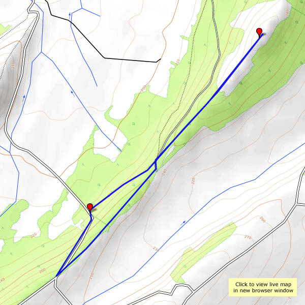
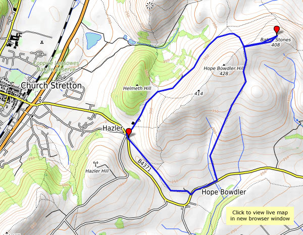
View OS map on Streetmap http://www.streetmap.co.uk/map.srf?X=351550&Y=298548&A=Y&Z=120

The mist came down

Blue sky by lunchtime, with lots of nice wispy cirrus – an ideal afternoon for the hills? We drove out to Hope Bowdler, but the clouds regrouped (despite the forecast) and, by the time we arrived at the Battlestones, the mist was coming down. No return along the ridge today – we’ll take the lower path and keep the views.

opentopomap.jpgView OS map on Streetmap http://www.streetmap.co.uk/map.srf?X=347905&Y=293531&A=Y&Z=120

Autumn in the dale

That’s Coalbrookdale – and Ironbridge – a good place for a pleasant walk on a sunny afternoon, after a couple of rainy days. There’s no shortage of visitors in the vicinity of the bridge (it is half-term week, after all), but away from the bridge it’s quiet. The leaves are coming down rapidly now – the trees will soon lose their colour.

opentopomap.jpg

View OS map on Streetmap http://www.streetmap.co.uk/map.srf?X=367255&Y=304041&A=Y&Z=120

A privileged position

SBJ - One hundred and eighty!
SBJ – One hundred and eighty!

…looking down on the trains running in and out of Shrewsbury station, from three of its now-famous signal boxes. Shrewsbury is an island of mechanical signalling, a survivor because of its complexity, among other things. It came within a hair’s breadth of resignalling perhaps 30 years ago (what would we have been left with? Fewer platforms and less track, I suspect – and insufficient capacity for today’s intensive services). Its fame? Primarily because, for the last few years, Severn Bridge Junction, with its 180-lever frame, has been the biggest mechanical signalbox in the world. Wow! More photos will follow in a day or two, on Geoff’s Rail Diaries; in the meantime, a taster…

The Munslows – an afternoon on the Edge

One we’ve done many times – park at Aston Munslow, then follow field tracks and, in places, sunken and/or hidden ways, along the second of the Wenlock Edges. It’s higher here than the generally more obvious first edge, to the north-west, topping out at 324m – about 1063ft. There are autumn leaves, toadstools, blackberries (still), crazy pheasants, and fine views to the Clee hills and Mortimer Forest. The last downhill stretch into Munslow is particularly deep and well hidden; the surface is, in places, the rock of the Wenlock Edge.

Map

View OS map on Streetmap http://www.streetmap.co.uk/map.srf?X=351160&Y=287706&A=Y&Z=120