Packetstone and Ashes

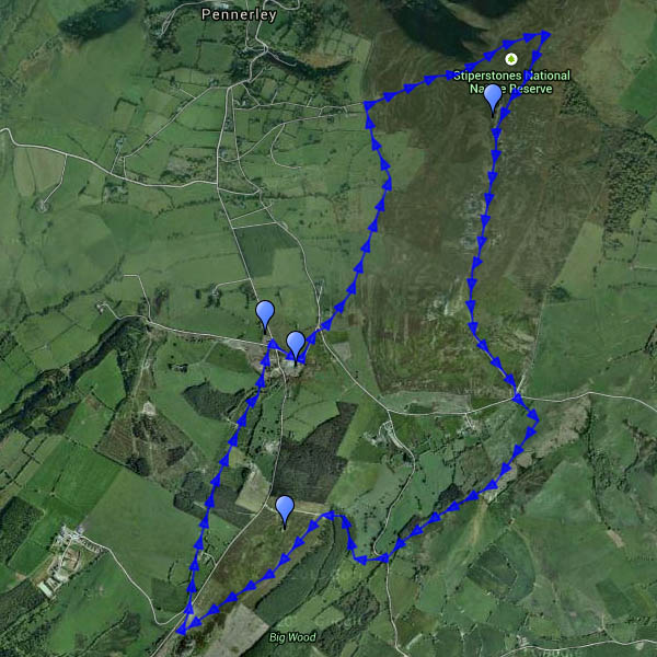
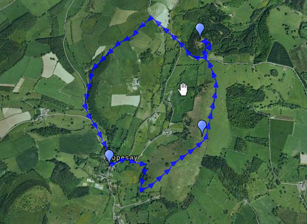
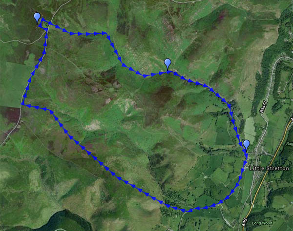
Having made a plan, one should adhere to it… This walk was going to be “Callow Hollow and…”, but when we’d followed the route through the plantation to gain access to Callow Hollow, we looked at the descent, then looked at the steep but inviting ridge ahead – and continued up the hill instead. The good path which we joined on reaching the plateau gradually fizzled out, and we eventually gained the road after struggling through tussocky heather. There is, of course, an excellent track on the southern flank of Packetstone Hill, but I’d forgotten about it…

We had debated leaving jackets in the car – although the air was cold, the sunshine in Little Stretton was comfortably warm. We got this decision right – we were glad of them on top where, when the sun dodged behind the clouds (few and far between) the breeze became a bitter wind. Dropping down into Ashes Hollow, we were out of the wind, and the late afternoon sunshine was very pleasant.

Map

View OS map on Streetmap http://www.streetmap.co.uk/map.srf?X=342505&Y=292436&A=Y&Z=120

Wesley Brook

Thursday: a waterside walk from Shifnal to Grindleforge bridge, near Ryton, following the Wesley Brook as it makes its way toward the Worfe – down the west side, and back up the east. It’s all very gentle country – we’re not in the Shropshire hills today. That may be a good thing – there’s only the lightest of breezes, and it feels warm in the fields – the shady wooded stretches come as a relief. Spring is really getting going now – lots of colour beside the path.

Map

View OS map on Streetmap http://www.streetmap.co.uk/map.srf?X=374345&Y=305606&A=Y&Z=120

Then and Now

ThenNowWhat a contrast! We first met this little Davenport (US) 0-4-0 saddle tank in June a couple of years ago, when it was newly arrived at Statfold from industrial service (and a few years out of use) in India. Today it was in service, operating trains for the Industrial Railway Society, and looking rather smart in a clean black livery. Hard to believe it’s the same locomotive!

More photos will appear on Geoff’s Rail Diaries in a day or so.

A breezy day on Brown Clee

Saturday afternoon:  we started out up the eastern slopes, where woodland (despite recent felling) and the hill itself were sheltering us from the breeze. On top, that breeze was an icy blast – what a contrast after a balmy Friday evening. The view to the west was extensive – the Brecon Beacons clearly defined to the south-west, some 55 miles distant according to the toposcope on Abdon Burf – but we didn’t stay long, cutting back through the woodland edge at the col. Once we were just a few feet lower, in the lee, it was a warm and pleasant afternoon again – perfect for wandering slowly down through the estate and back to the car.

MapView OS map on Streetmap http://www.streetmap.co.uk/map.srf?X=359915&Y=286471&A=Y&Z=120

Hopesay Hill and Wart Hill

Hopesay lies in a side valley off the Clun valley – so quiet that it should have been listed with the latter’s “quietest places under the sun”. Its hill, owned by the National Trust, is an airy grassy ridge, adorned by a well-placed clump of trees. Wart Hill, immediately to the north of Hopesay Hill, is clad in forestry pines, which thin towards its top sufficiently to appreciate how good the view would be if they were all cut down… It’s Easter Sunday, but there are few others about – one or two walkers, a farmer tending his sheep. And, of course, the buzzards – and red kites (or possibly one red kite three times). One landed in a tree close by, a brief glimpse of colour before he was away again, too quick for the camera (or its operator…)

MapView OS map on Streetmap http://www.streetmap.co.uk/map.srf?X=339460&Y=284065&A=Y&Z=120