A wander around the museum with the camera, on a fine sunny afternoon.


…or perhaps its grandfather? It’s the world’s first iron-framed building – built as a flax mill in 1797, it was converted to maltings in 1897 – and remained in use as such, on and off, until 1987, by which time its historic significance (and a Grade 1 listing) ensured continued existence. Work is now ongoing to restore the buildings on this site in Shrewsbury to further commercial – and community – use, work that will not be finished overnight. Our visit today, with an excellent guided tour, was a (free) Heritage Open Day event, and well worth a donation to funds. Must have another look in a year or two…
Friends of the Flaxmill Maltings


Everything’s in flower, or so it seems, and the butterflies are beginning to cooperate… We’re making the most of a dry and sunny afternoon after a day of rain, with another to come tomorrow, if the forecast is right. The youth hostel at Coalport (beside the china museum) is open for tea and cakes all summer, and the walk’s long enough to feel we’ve earned it (as if we needed an excuse…)


Scenes from the walled garden at Attingham Park (and a walk around the park afterwards).


A showery day – perhaps not ideal for a long walk. How about Blists Hill? – we haven’t been there for a while, and there’s plenty of shelter if it rains. (It didn’t…)


There’s many a double-take by passing motorists on the Shrewsbury – Wenlock road – “Did that sign really point the way to Wigwig and Homer?”. Yes, a hamlet and a small village well-hidden, despite the sign, beneath the northern end of the Wenlock Edge. This was a very pleasant circuit, starting from Sheinton, following farm lanes and tracks past Belswardyne Hall to Harley. “Look at that – the sun’s got a halo”. There’s no need to enter quiet Harley village, and it means crossing the busy A458 twice – but it saves walking beside the noisy road. The lane to Wigwig crosses what was once a ford, and probably still is in very wet weather. In Homer, we leave the road and take to fields of sheep, followed by attractive woodland beside Sheinton brook, then more fields of sheep – and we’re back in Sheinton.


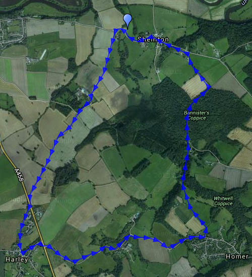
View OS map on Streetmap http://www.streetmap.co.uk/map.srf?X=361005&Y=302661&A=Y&Z=120
Monday – a walk into Telford Town Park. We started from the southernmost tip, close by the aqueduct, to walk nearly two miles mostly along and beside the old Coalport railway trackbed to the town centre. The paths are well made (there was a lot of rain on Saturday…), many and varied – quite a maze as we near the offices, shops and restaurants. The railway followed the route of an old canal, still evident in places, providing a pleasant and varied landscape in the “wild” park. It’s much tamer close by the town centre, and there are many more people. It’s good to turn and head back past the tall Stirchley chimney to the relative quiet of the railway cutting, a long cool hollow on this warm afternoon.


View OS map on Streetmap http://www.streetmap.co.uk/map.srf?X=369850&Y=307441&A=Y&Z=120
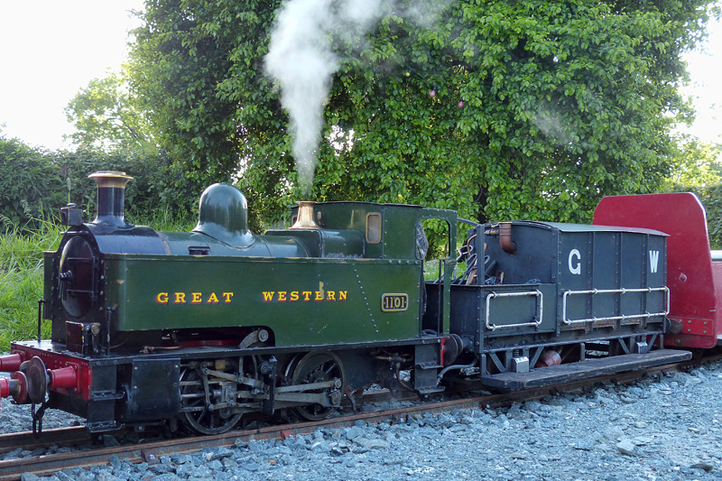 That’s a misleading, though accurate, title. A 7¼” gauge railway has recently been constructed at Canal Central, beside the Montgomery Canal at Maesbury Marsh. It’s not open to the public yet – this was a private visit on a perfect summer’s evening. For more pictures and video, visit “Canal Central” on Geoff’s Rail Diaries
Canal Central Tearoom, shop, Post Office, etc.
A wander on a warm Sunday afternoon, beside the Severn near Apley, returning to the car through woodlands and fields


They’re too good to waste! Bright sunshine, fluffy clouds, not too warm – ideal for wandering.
Wednesday: To Benthall Edge and Hall (tea and cake)


Thursday: Long Mynd. A route we’ve done many times, starting from the Cardingmill valley and ascending via the Lightspout (hoardes of schoolchildren – it’s peak field trip season). Beyond the waterfall it’s quiet – just the sheep and the hill ponies to accompany us to Pole Bank. We return along the ridge to Townbrook Valley, a pleasant path to take us back to the start.


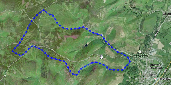
View OS map on Streetmap http://www.streetmap.co.uk/map.srf?X=343005&Y=294546&A=Y&Z=120
