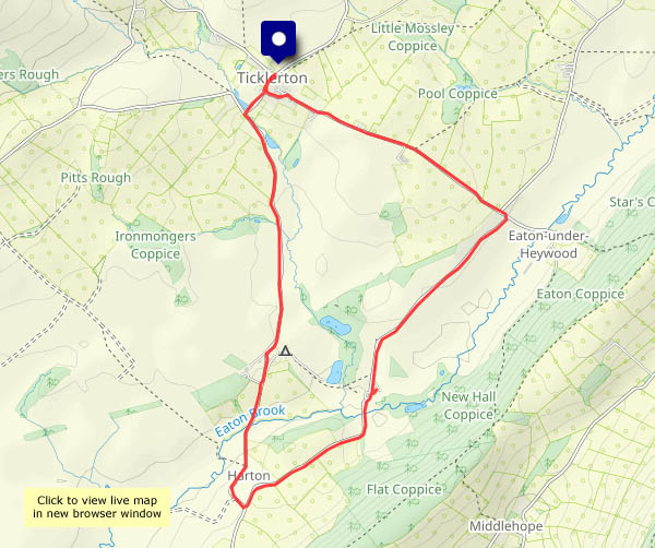
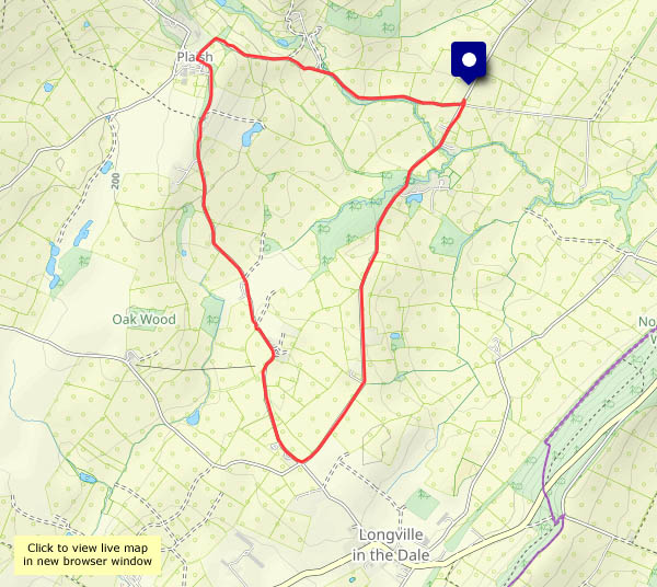
Clun Castle

We’ve visited Clun from time to time over many years, but it’s a long time since we last visited the castle. Its namesake, the GWR-designed ‘Clun Castle’, no. 7029, is possibly much better known (see Clun Castle on Geoffspages blog) – the castle itself is not the most impressive of ruins. However, it’s photogenic on its mound high above the river Clun on this bright but showery afternoon, and there are some fine views of the surrounding countryside.

View OS map on Streetmap http://www.streetmap.co.uk/map?X=330120&Y=280570&A=Y&Z=126

Not many more…

It won’t be long before we enjoy this year’s last evening walk – the nights are rapidly drawing in. We’ll make the most of it on this occasion, when the air is clear and cool after a few showers earlier. The two young deer were a bonus, but a passing car (one of only three or four that passed us) disturbed them and off they went, into the woods. I don’t think they were planning on staying anyway.

View OS map on Streetmap http://www.streetmap.co.uk/map?X=365790&Y=298180&A=Y&Z=120

By Coundmoor Brook

Up the lane to Harnage, then across the fields, past the farm reservoir to the path beside the wood, high above Coundmoor Brook. Down to the ford, then back along the delightful brookside path, where the snowdrops grow at the other end of the year… A very pleasant gentle wander on a warm afternoon.

View OS map on Streetmap http://www.streetmap.co.uk/map?X=355950&Y=304180&A=Y&Z=120

Continued…

Just a few… A day later, and it still feels autumnal, though the sun is trying to peep through. We’re in more-or-less the same place as yesterday, but a little higher, on the shoulder of Shirlett Common – up Round Hill, down Ned’s Lane and back along the road to the start. The bracken is golden, the black bryony is living up to its name, and there’s a super big mushroom, some kind of boletus I think. We’ll leave it where it is, of course, for others to see and enjoy. It may be edible, in the same sense that Russian roulette isn’t always fatal…

View OS map on Streetmap http://www.streetmap.co.uk/map?X=367135&Y=297490&A=Y&Z=120

Autumnal

It won’t be September for another two weeks, but there’s an autumnal feel to the quiet lanes around Willey (and it’s much cooler than of late, just 15C). There are blackberries and damsons in great profusion – I don’t think I’ve seen so many at this time of year. Plenty of other sights and smells too – ripening apples, elderberries and sloes, and lots of wild hops. Rub a hop flower between your hands and sniff – who’s for a pint of best bitter?

View OS map in Streetmap http://www.streetmap.co.uk/map.srf?X=367470&Y=298250&A=Y&Z=120

A Severnside morning

The air’s cool on this bright sunny morning – let’s make the most of it with a pre-lunch wander: down the very quiet Stanley Lane (three walkers, two cyclists) to Lower Severn Hall, then back along the riverside path to the woods of Chestnut Coppice. The uphill stretch (it’s very short, and not very steep) is rewarded with two wonderful fungal growths on dead wood – chicken of the woods and velvet-top fungus (I think!). They’re interesting subjects for the camera, whatever they are, but I certainly wouldn’t want to eat them…

View OS map on Streetmap http://www.streetmap.co.uk/map?X=372025&Y=296540&A=Y&Z=120

Scattered showers

We needed a short leg stretch – where? There was a light shower at home before lunch, and the forecast said “scattered showers”. If we go to Attingham, there’s plenty of shelter. That’s just as well – the rain seemed to focus on the area. Happily we found the expected shelter (a brick arch, the trees) and didn’t get noticeably wet, but we thought our usual longer route, much of it rather open, could be tempting fate. The rain stopped (great timing) just as we left the woods. A mile or so from Attingham, on the shortish drive home, the roads were dry. I’d hoped the garden might have had a drop. No chance! Scattered indeed.

View OS map on Streetmap http://www.streetmap.co.uk/map?X=355280&Y=310145&A=Y&Z=120

Skateraw and Barns Ness

Wednesday 6 August: a walk along the shore. Skateraw lime kiln is just a few yards along the rock slab shore from the Torness nuclear power station, a prominent landmark on the coast of East Lothian. A couple of miles to the north-west is another highly visible landmark, the lighthouse at Barns Ness. Dating from the turn of the 20th century, it was deactivated twenty years ago, and is now in use as holiday accomodation. The shore path is very pleasant, with fine views to sea and plenty of white waves – most enjoyable for an afternoon stroll.

View OS map on Streetmap http://www.streetmap.co.uk/map?X=373167&Y=676267&A=Y&Z=120

Flight!

Tuesday 4 August: Scotland’s National Museum of Flight is just down the road from Dunbar, at East Fortune’s former WW2 airfield. We’d better pay it a visit!

We’re not experts on things that fly, though we have taken to the air once or twice. Geoffspages’ first flight (and only one in a jet*) was many years ago, from Birmingham to Munich (a school ski-ing trip), in a BAC 1-11 – just like that one over there! Seemed very modern at the time… So did Concorde, a few years later, when it roared overhead during occasional family visits west of Heathrow. There’s one on display here! At the other end of the scale, there’s a home-made plane, based around a VW ‘Beetle’ engine (amazing!) – and just about everything in-between.

* the others: a propeller-powered cross-channel hop, a short spin (not literally) in a 2-seater Cessna, and a helicopter flight over our little corner of Shropshire. I guess I ought to try a hot air balloon one of these days, or maybe a hang-glider? Maybe not…

NMS National Museum of Flight