Bog, Black Ditch and Black Rhadley

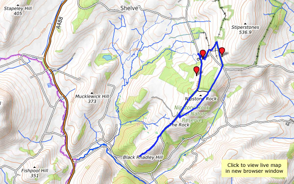
There’s barely a cloud in the blue sky – it’s a day that’s too good to waste. We’re off to The Bog, for a walk along the southern ridge of the Stiperstones to Black Rhadley, and when we get back, the Bog Centre is open for tea and cakes. What more could one ask? That was intended to be a rhetorical question, but I’ll answer it anyway: “peace and quiet” – and yes, we had that too. Despite the weather being unusually good, we saw hardly anyone else on our walk, the shooters at the range were quieter than normal and even the dogs in the kennels failed to disturb the calm (there must have been others about – the cakes had nearly all gone!).

Bog Visitor Centre

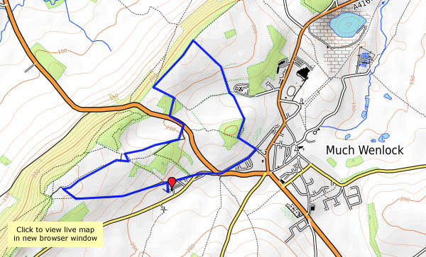
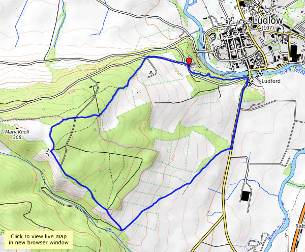
View OS map on Streetmap http://www.streetmap.co.uk/map.srf?X=335045&Y=296846&A=Y&Z=120

Dingles and dereliction

Easter Monday: an exploration of land within two or three miles of home, not normally accessible to the casual explorer. In order gain access, the permission of the various farmers and others had to be sought in advance (many thanks to Myra for doing the – er – groundwork, and to the family for wonderful and timely refreshments).

It’s unbelievably soggy underfoot, following a night of heavy rain (did I mention it’s a bank holiday?) – after seeing the forecasts earlier in the week, we’ve done remarkably well to stay fairly dry. As well as the mud, there are atmospheric remnants of the rain – a general murk and mist in the trees, adding to the melancholy of the sad, abandoned dwellings we encounter, remote from civilisation and “mod cons”. The dingle is a delight – with the added interest of a flow of natural bitumen part-way down the faint path.

Into the woods

A short walk from Ludlow. We’ve parked facing the well-known view of the town, with the castle and church prominent against the backdrop of Titterstone Clee. A cloud is casting deep shade over the castle, though the rest of the town is floodlit. Perhaps on our return?

Our walk takes us a short way along the old A49, then up to the woodland past Hucksbarn and Starvecrow. There are some fine views on this clear afternoon – until we enter the woods, by which time the cloud has thickened and the sunshine gone. There are thick plantations of conifers at first, but as we descend towards Ludlow the woodland becomes more varied and interesting.

View OS map on Streetmap http://www.streetmap.co.uk/map.srf?X=350060&Y=273470&A=Y&Z=120

It’s never dull at Statfold

Even when the weather is gloomy… Today was the first of this year’s open days at the Statfold Barn Railway. The March event can be really great for photography if the sun shines – but apart from a few minutes when the sky was (partially) blue and the sun shone, the weather was unremittingly dull. At least it didn’t rain. There was plenty of interest, and lots going on – and a real eye-opener in Oak Tree shed. A “Rail Diaries” page will appear tomorrow or Monday – in the meantime, here’s a taster.

Rhubarb and Spanish

Wednesday 21 March: If, as a child, I’d had a threepenny bit (3d, that is, not 3p) to spend on sweets, there was a fair chance that the selection purchased would include a piece of “Spanish”. That’s what we called liquorice, and though its origins might well have been Iberian, the sweets were probably made in or around Pontefract. Just a little way to the west is Wakefield and the “Rhubarb Triangle”, still notable for its forced rhubarb. Today, armed with Northern Rail day rover tickets, we’ll be travelling around the area of rhubarb and Spanish. It’s a “Rail Diaries” outing – a web page will follow shortly…