Saturday 12 June: An hour and a half around the lanes near Willey, on a perfect summer evening.


")


Saturday 12 June: An hour and a half around the lanes near Willey, on a perfect summer evening.
Friday 11 June: Walking in the border hills, between Llangunllo and Knighton. This red kite glided down ahead of us, and perched on a fence post for a few minutes. It looks as though he (or she) has been out in the rain (it’s trying, but we’re not really getting wet), and doesn’t look too happy about it…


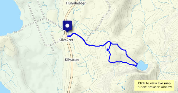
Saturday 29 May: On my own again today, avoiding the crowds by parking near the Kilmuir village hall and walking across the moorland to Loch Sneosdal, a quiet stretch of water tucked below dark crags, not visible from any road. Heading back from the clear waters of the loch, my eye is caught by pools atop the moorland to the south of the usual route. In a reversal of the normal sequence of events, the sun comes out as I approach them – wonderful!


View OS map on Streetmap http://www.streetmap.co.uk/map?X=139879&Y=869983&A=Y&Z=120
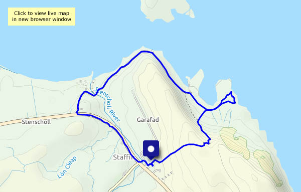
Friday 28 May: an enjoyable short stroll around Staffin. Starting from Columba 1400, we take the path over the moor, past the chambered cairn and down to the rocks south of the slip. The beach and slip are fairly popular, but hardly anyone explores beyond the latter. After watching the waves for a while, we continue past the slip and the beach towards Quiraing Lodge (‘Staffin House’ on old maps), then back beside the main road and the highland cattle.


")
")


View OS map on Streetmap http://www.streetmap.co.uk/map?X=148838&Y=867786&A=Y&Z=120
Thursday 27 May: Skye’s Trotternish peninsula is firmly on the selfie trail – perhaps six miles to the north, as the golden eagle flies, there are hundreds of people milling around at the Quiraing (I’ve just driven over the road from Uig – there must have been 120-150 cars parked at the top of the pass), and three or four miles to the south, a similar number will be trying to enjoy the spectacle of the Old Man of Storr. Loch Cuithir is almost deserted – I saw just one other person in the two-and-a-half hours I was walking. He looked like a local, with a sheepdog, driving slowly in a van along the very rough track.
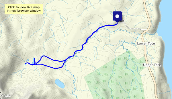
The bed of the loch was a rich source of diatomite, a form of silica with a honeycomb-like structure having a wide variety of industrial uses. It was worked commercially around 100 years ago – a 2-foot gauge railway was used to take the raw product to the shore at Lealt where there were processing facilities. Although long-disused, the trackbed of the old railway is still visible along most of its three mile length, and though boggy in places it is walkable (I walked most of the way along the road/track, using the last mile or so of the old railway to reach the loch. It would have been very slow going to walk it the whole way). One or two small bridges have gone – some rails remain in their vicinity, well-rusted. The loch itself lies below the spectacular peak of Sgùrr a’ Mhadaidh Ruaidh – the Peak of the Red Fox.


")


View OS map on Streetmap http://www.streetmap.co.uk/map?X=149514&Y=860166&A=Y&Z=120
Wednesday 26 May: Rather murky too – a gentle reminder of how lucky we’re going to be with the weather for the next week or so. A walk from the pier as far as the river Conon, then back through the woodlands and Idrigill.


View OS map on Streetmap http://www.streetmap.co.uk/map?X=139040&Y=863677&A=Y&Z=120
Tues 25 May: a good leg-stretch after yesterday’s fun – a walk through Bornesketaig to the clifftops, following them westwards to look down on the Uamh Oir (a cave of gold!), then along the shore to Camas Mòr. There’s a towering bank of cloud over Lewis and Harris, but here the skies are blue. We’ve left winter behind!


View OS map on Streetmap http://www.streetmap.co.uk/map?X=137825&Y=870862&A=Y&Z=120
Monday 24 May: We’re on our way to our ‘Northern Office’, and though there will be some domestic duties to attend to, there will also be opportunities for outings – some on my own, when I can be a little more adventurous…
The weather at home has not been great recently, and as we drive through Dalwhinnie, taking the road to Spean Bridge, the car tells us it’s just 5°C outside. The steady drizzly rain, which has caused much spray on the A9, appears to be falling as wet snow on the mountaintops, which are just-about visible through the cloud and mist enveloping them. We’ll pause for a few minutes and a very short leg stretch (it’s still drizzling) where the river Pattack flows peaty-brown through a little gorge beside the road.
A little over three hours later, we’ve arrived. The rain has stopped – Skye is dry! – and the sun is gradually going down behind the Western Isles. The light catches a shower in the Minch. I stand (too much sitting today!) and gaze at the scene, glass in hand, and the long drive begins to unwind. Tomorrow will be a better day.


It’s likely to be the best part of the day, according to the forecast. Sure enough, the sky is clearing and the sun is shining (it’s not very warm though!). Familiar territory – Shirlett Lane, and the tattie fields…


")


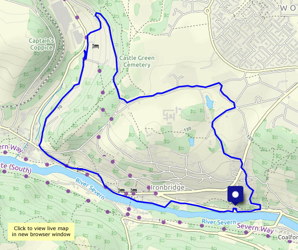
The Severn is always cloudy by comparison with, say, a chalk stream, or the peaty waters of a highland glen, but at present they’re muddier than usual – must be all the rain… Speaking of which, it was supposed to rain all day, but we found a likely dry spell in the forecast, and enjoyed this short walk from Bedlam furnaces (car parking) up and over the hill to Coalbrookdale, and back through Ironbridge. On the riverbank is the shed where (we remember him well) Eustace Rogers used to build his coracles. Sadly ‘Eusti’ was the last of his line, and the shed is now a tiny museum, which can only be visited by peering through the glass window. Just below the world-famous Iron Bridge, here’s another fascinating little bit of history on an altogether more human scale.
Tributes paid to coracle man BBC News 10 February 2003


View OS map on Streetmap http://www.streetmap.co.uk/map?X=367490&Y=304005&A=Y&Z=120
