Brown Clee from the phone box

We’ve done this one before (the phone box in question no longer contains a phone – instead, it’s now the “Little Red Book Stop”) – see “A clear day on Clee Hill” . It was clear this afternoon, warm when the sun shone – which wasn’t often, nor was it for long –  nevertheless, it’s a good place to be.

Map

View OS map on Streetmap http://www.streetmap.co.uk/map.srf?X=359005&Y=286906&A=Y&Z=120

Hay to Hampton

From Hay Bridge, near Eardington, to Hampton Loade, a pleasant path follows the Severn – though with riverside vegetation and a tall crop of oilseed rape, there’s not always much of a view. Banded demoiselles flop around like tiny world war 1 biplanes in an apparently clumsy manner, until one proves its aerobatic capabilities by snatching a passing fly and making lunch of it. We didn’t snatch anything, but the ice creams at Hampton Loade station were enjoyable on this increasingly warm afternoon, and the platform a pleasant spot to sit for a while watching the world go by. The latter happens in fits and starts – it’s busy when trains call, otherwise quiet (perhaps not quite Adlestrop).

Walking back to Hay Bridge, we follow a quiet way past Chelmarsh reservoir, where there are just a couple of boats out – not enough wind today.

Map

View OS map on Streetmap http://www.streetmap.co.uk/map.srf?X=373765&Y=287531&A=Y&Z=120

Sheinton Coppices

Wandering south of the Severn, through quiet woodlands and fields. The OS map defines several of the small woods as coppices, and one or two were still recognisable as such, though no recent work was obvious – unlike the extensive clearance that had been taking place at Traps Coppice. A small herd of wild deer grazed on the hillside just to the north of Farley Coppice – if they had seen us, they weren’t concerned. The rabbit saw us eventually…

Map
View OS map on Streetmap http://www.streetmap.co.uk/map.srf?X=362460&Y=303461&A=Y&Z=120

Packetstone and Ashes

Having made a plan, one should adhere to it… This walk was going to be “Callow Hollow and…”, but when we’d followed the route through the plantation to gain access to Callow Hollow, we looked at the descent, then looked at the steep but inviting ridge ahead – and continued up the hill instead. The good path which we joined on reaching the plateau gradually fizzled out, and we eventually gained the road after struggling through tussocky heather. There is, of course, an excellent track on the southern flank of Packetstone Hill, but I’d forgotten about it…

We had debated leaving jackets in the car – although the air was cold, the sunshine in Little Stretton was comfortably warm. We got this decision right – we were glad of them on top where, when the sun dodged behind the clouds (few and far between) the breeze became a bitter wind. Dropping down into Ashes Hollow, we were out of the wind, and the late afternoon sunshine was very pleasant.

Map

View OS map on Streetmap http://www.streetmap.co.uk/map.srf?X=342505&Y=292436&A=Y&Z=120

Wesley Brook

Thursday: a waterside walk from Shifnal to Grindleforge bridge, near Ryton, following the Wesley Brook as it makes its way toward the Worfe – down the west side, and back up the east. It’s all very gentle country – we’re not in the Shropshire hills today. That may be a good thing – there’s only the lightest of breezes, and it feels warm in the fields – the shady wooded stretches come as a relief. Spring is really getting going now – lots of colour beside the path.

Map

View OS map on Streetmap http://www.streetmap.co.uk/map.srf?X=374345&Y=305606&A=Y&Z=120

A breezy day on Brown Clee

Saturday afternoon:  we started out up the eastern slopes, where woodland (despite recent felling) and the hill itself were sheltering us from the breeze. On top, that breeze was an icy blast – what a contrast after a balmy Friday evening. The view to the west was extensive – the Brecon Beacons clearly defined to the south-west, some 55 miles distant according to the toposcope on Abdon Burf – but we didn’t stay long, cutting back through the woodland edge at the col. Once we were just a few feet lower, in the lee, it was a warm and pleasant afternoon again – perfect for wandering slowly down through the estate and back to the car.

MapView OS map on Streetmap http://www.streetmap.co.uk/map.srf?X=359915&Y=286471&A=Y&Z=120

Hopesay Hill and Wart Hill

Hopesay lies in a side valley off the Clun valley – so quiet that it should have been listed with the latter’s “quietest places under the sun”. Its hill, owned by the National Trust, is an airy grassy ridge, adorned by a well-placed clump of trees. Wart Hill, immediately to the north of Hopesay Hill, is clad in forestry pines, which thin towards its top sufficiently to appreciate how good the view would be if they were all cut down… It’s Easter Sunday, but there are few others about – one or two walkers, a farmer tending his sheep. And, of course, the buzzards – and red kites (or possibly one red kite three times). One landed in a tree close by, a brief glimpse of colour before he was away again, too quick for the camera (or its operator…)

MapView OS map on Streetmap http://www.streetmap.co.uk/map.srf?X=339460&Y=284065&A=Y&Z=120

Great Rhos and Black Mixen

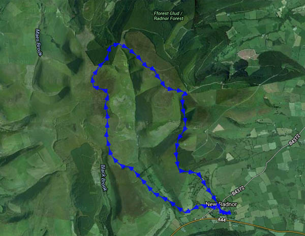
From the Shropshire hills, a great flat-topped dome dominates the southern distance – Radnor Forest (not a forest, though the hill’s northern slopes are well-covered with conifers). Prominent, with good eyesight or binoculars, is the (TV?) mast on Black Mixen. It follows that, given good weather, its views should be extensive and panoramic. We’d better go and find out.

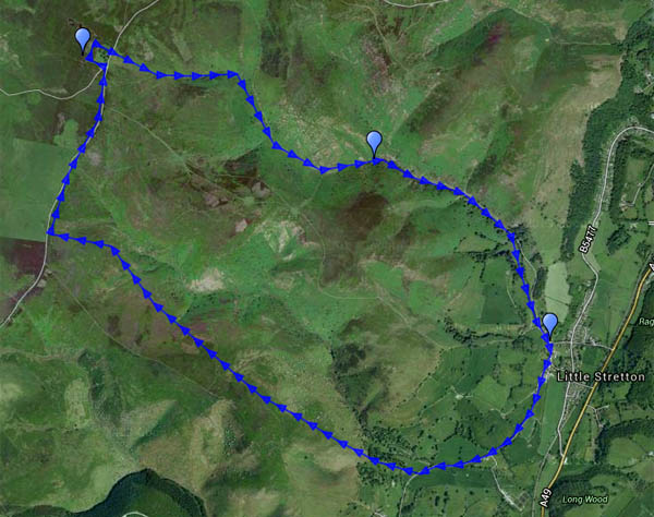
It looks like one big hill – in fact it’s very nearly two – the deep and forbidden Harley Dingle (ammunition testing ranges!) almost bisects Radnor Forest. Great Rhos is the highest point (that’s the wrong word to use), at 660m (2166′), on the western side. It connects to the eastern Black Mixen (650m) by a narrow neck of land on the fringe of the forest. From the sleepy streets of New Radnor, the route is thus a high-level horseshoe, providing an excellent day out in this very quiet hill country (one other walker, and a distant horse-and-rider). There are more red kites than people. The views? Yes, as we imagined – a 360° panorama – hills in all directions. Wonderful!

Map
View OS map on Streetmap http://www.streetmap.co.uk/map.srf?X=319679&Y=262054&A=Y&Z=120