Wood and stone: Clive and Grinshill

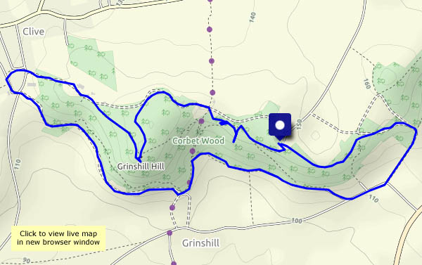
The morning’s fog has cleared, though it’s still quite hazy north of Shrewsbury. We’re following our usual route, with variations – out by the path around the south side of the hill, turning back at Clive and heading for the “summit” (just 630 feet, or 192m), then back through the old quarries. It’s a popular spot, especially on a fine sunny day.

View OS map on Streetmap http://www.streetmap.co.uk/map.srf?X=352205&Y=323656&A=Y&Z=120

Bannister’s and Traps

Saturday 23 February: A walk from Wenlock, on a fine dry afternoon. It’s almost “fine sunny afternoon”, but an approaching weak weather front takes the sunshine away (it didn’t get far – there was clear blue sky not too many miles to the east). The woods are quiet – there’s no wind. In Bannister’s Coppice, a rustling to our left reveals a herd of deer, perhaps 20 or more, well-hidden and impossible to photograph. There aren’t any deer in Traps Coppice today – just hundreds of pheasants, whose likely life expectancy is probably very short…

View OS map on Streetmap http://www.streetmap.co.uk/map.srf?X=362175&Y=301916&A=Y&Z=120

Highest in the county

We stood  above everyone else in the county at about 2.45 this afternoon, when we gazed out from Abdon Burf on Brown Clee, Shropshire’s highest point (1772 feet, or 540m). It’s a good place to be on an afternoon like this – positively springlike, it would be a crime to stay indoors. It’s quiet too – despite being school half-term week, we saw just four other people while we walked. Wonderful!

View OS map on Streetmap http://www.streetmap.co.uk/map.srf?X=360130&Y=285861&A=Y&Z=120

In Mortimer Forest

We’re walking from Ludlow into the hilly forest to the south-west, a route which takes us into Herefordshire, via the delightfully-named Sunnydingle Cottage to a summit at High Vinnals. 375m (1230 feet) is no great height, but the view is tremendous. That is, it would be, if it wasn’t for the showers of light rain here and there (no, the weather isn’t being as friendly as we’d expected). We return past Mary Knoll House, slithering downwards on the slippery clay, back to very welcome tea and cake, just right for the journey home.

View OS map on Streetmap http://www.streetmap.co.uk/map.srf?X=349560&Y=273526&A=Y&Z=120

A walk to Wenlock

A couple of weeks ago, we caught the bus to Much Wenlock and walked back (see A walk from Wenlock). Today, one of us will be spending some time in Wenlock – if I time it right, I can get a lift back. It’s more-or-less the same route, but in reverse the views are different – mostly. It’s a fine sunny day – not a cloud in the sky – too good to waste!

View OS map on Streetmap http://www.streetmap.co.uk/map.srf?X=364795&Y=301296&A=Y&Z=120

Snailbeach and the Devil’s Chair

The fog has cleared and it’s a beautiful afternoon for a walk on the Stiperstones. We’ve started from Snailbeach, and gone up past Resting Hill chimney, skirting Crowsnest Dingle to reach the ridge. The Devil’s not in his chair today, fortunately. To the south, a hazy remnant of the fog fills the valley, glowing in the bright sunshine. Red kites wheel above the ridge (out of range of the camera). We return on lower paths, gazing wistfully on the Bog Centre, not yet open for tea and cakes… It’s been a great day, out on these hills.

View OS map on Streetmap http://www.streetmap.co.uk/map.srf?X=336965&Y=299776&A=Y&Z=120

A walk from Wenlock

We’ll catch the bus and walk back… It should have been wall-to-wall sunshine, but clouds are blowing across from the north-east – we’ll have to be selective with the photos. We’re certainly not going to stand and wait until the sun shines – it’s much too cold, barely above freezing. Nevertheless, it’s pleasant when the sun’s out, and there are one or two reminders that spring isn’t too far away.

View OS map on Streetmap http://www.streetmap.co.uk/map.srf?X=364840&Y=301361&A=Y&Z=120

Winter sun on Hope Bowdler

Not as much as we’d hoped for. We were anticipating snow too – there was a light cover at home, but hardly any here. Road closures delayed us, and by the time we’d reached the top of Hope Bowdler Hill, a bank of cloud from the west was stealing the sunshine. It’s good up here, especially when the sun is out, but now it’s gone – so has the light, and the wind’s cold. Let’s omit the Battlestones (just this once!) – we’ll cut our losses and head for home.

View OS map on Streetmap http://www.streetmap.co.uk/map.srf?X=347617&Y=293618&A=Y&Z=120