Stiperstones strolling

It has to be a stroll – the path along the ridge is far too rough for any speed. Slow progress is essential if the view is to be appreciated without broken bones… The distant views are wonderful, in all directions; closer, there are other items of interest – a red kite, toadstools (just a few), a fine hairy coo – and the alpacas… It’s a great day to be up here – fine and clear, bright and cool (and breezy).  Nevertheless, it’s good to get back to the Bog too – the cakes are splendid. What an enjoyable day!

View OS map on Streetmap http://www.streetmap.co.uk/map.srf?X=336175&Y=298046&A=Y&Z=120

A Cound Circular

It’s a slightly-extended version of a walk we did earlier in the year, and for the same reasons. There’s been a lot of rain in the last couple of days; now the sky’s mostly clear blue, and we need to make the most of it, but we’ll have to stay on hard roads and tracks unless we want to get seriously bogged down. It’s a very pleasant leg-stretch, and as the afternoon wears on, the sun gets noticeable lower, spotlighting the landscape and leaving deep shadows.

We left the car at Cound Guildhall, where there’s a charity box for parking and a charity bookshop too: St Peters Charity Bookshop

View OS map on Streetmap http://www.streetmap.co.uk/map.srf?X=355585&Y=303886&A=Y&Z=120

Chase again

That’s Cannock Chase, of course. The forecast implied there would be more sunshine than we had before lunch; afterwards, things improved a bit. At least it’s not raining, and it’s generally dry underfoot too. We’d hoped for more autumn colours, and thought there might have been a good crop of toadstools… The visitor centre, half-way around our wander, is reliable for a simple snack lunch (bacon baps) – and it’s good to be out on a day like this.

View OS map on Streetmap http://www.streetmap.co.uk/map.srf?X=398540&Y=316611&A=Y&Z=120

Via Random

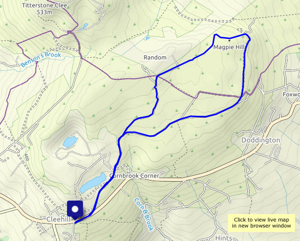
We’ve left the car at Cleehill village, and we’re heading for the spooky remains of industry on Magpie Hill. It’s a grey day, and the air’s cold – it’s also clear, with views extending to the Brecon Beacons. Recent rains mean that, away from good surfaces, there’s no shortage of mud, so today we’re mostly on hard-surfaced tracks across this remote hill country. The outward route takes us past the curiously-named Lower Random Farm, on what was once a mineral wagonway, disused for more than a century. Inevitably, the sun breaks through when we’re in the car heading homewards; unexpectedly, it’s raining (again!) as we near home.

View OS map on Streetmap http://www.streetmap.co.uk/map.srf?X=360620&Y=276546&A=Y&Z=120


Fungi in the forest …

… toadstools amongst the trees. Wednesday: we’re back in sunny (sometimes) Shropshire, taking a leg stretch on Haughmond Hill, near Shrewsbury. There are showers about – the trees might give us some shelter (it wasn’t needed). Around the fringes of the forest, there are some extensive views to the south Shropshire hills; within the woods, there’s a profusion of all kinds of fungus – one of the joys of moving into autumn.

View OS map on Streetmap http://www.streetmap.co.uk/map.srf?X=354275&Y=313911&A=Y&Z=120

No fairies…

…the visitors have frightened them all away! Friday: a walk up to the Fairy Glen near Uig – with the emphasis on “walk”. The first time we visited this curious and fascinating landscape in miniature, we had the place to ourselves. That was perhaps getting on for 40 years ago – now it’s firmly on the tourist to-do list (remember to pack the selfie stick!). Driving up there is not to be recommended – parking is limited and potentially boggy, and then there are the adventure minibuses to contend with. But between the passing cars it’s quiet and a pleasant walk – and much easier to take in the scenery and the ambience.

View OS map on Streetmap http://www.streetmap.co.uk/map.srf?X=140635&Y=863337&A=Y&Z=120

Staffin shore and skyescapes

Wednesday: it’s misty and damp here, on the western side of Trotternish (as seems to happen fairly often), but just a few miles away, at Staffin on the eastern shoreline, it’s much clearer, with the odd sunny spell. There are showers about, but we seem to escape them. We walk over the hill from Staffin to the slip and the beach (beware of minibus tours!), then along to the rocks, before heading back over the hill to the car, to drive around the coast to the fog and gloom.

View OS map on Streetmap http://www.streetmap.co.uk/map.srf?X=149128&Y=867796&A=Y&Z=115