Staffin strolling

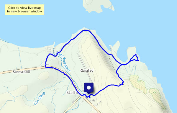
Friday 28 May: an enjoyable short stroll around Staffin. Starting from Columba 1400, we take the path over the moor, past the chambered cairn and down to the rocks south of the slip. The beach and slip are fairly popular, but hardly anyone explores beyond the latter. After watching the waves for a while, we continue past the slip and the beach towards Quiraing Lodge (‘Staffin House’ on old maps), then back beside the main road and the highland cattle.

View OS map on Streetmap http://www.streetmap.co.uk/map?X=148838&Y=867786&A=Y&Z=120

Loch Cuithir

Thursday 27 May: Skye’s Trotternish peninsula is firmly on the selfie trail – perhaps six miles to the north, as the golden eagle flies, there are hundreds of people milling around at the Quiraing (I’ve just driven over the road from Uig – there must have been 120-150 cars parked at the top of the pass), and three or four miles to the south, a similar number will be trying to enjoy the spectacle of the Old Man of Storr. Loch Cuithir is almost deserted – I saw just one other person in the two-and-a-half hours I was walking. He looked like a local, with a sheepdog, driving slowly in a van along the very rough track.

The bed of the loch was a rich source of diatomite, a form of silica with a honeycomb-like structure having a wide variety of industrial uses. It was worked commercially around 100 years ago – a 2-foot gauge railway was used to take the raw product to the shore at Lealt where there were processing facilities. Although long-disused, the trackbed of the old railway is still visible along most of its three mile length, and though boggy in places it is walkable (I walked most of the way along the road/track, using the last mile or so of the old railway to reach the loch. It would have been very slow going to walk it the whole way). One or two small bridges have gone – some rails remain in their vicinity, well-rusted. The loch itself lies below the spectacular peak of Sgùrr a’ Mhadaidh Ruaidh – the Peak of the Red Fox.

View OS map on Streetmap http://www.streetmap.co.uk/map?X=149514&Y=860166&A=Y&Z=120

Bornesketaig coastline

Tues 25 May: a good leg-stretch after yesterday’s fun – a walk through Bornesketaig to the clifftops, following them westwards to look down on the Uamh Oir (a cave of gold!), then along the shore to Camas Mòr. There’s a towering bank of cloud over Lewis and Harris, but here the skies are blue. We’ve left winter behind!

View OS map on Streetmap http://www.streetmap.co.uk/map?X=137825&Y=870862&A=Y&Z=120

A long journey

Monday 24 May: We’re on our way to our ‘Northern Office’, and though there will be some domestic duties to attend to, there will also be opportunities for outings – some on my own, when I can be a little more adventurous…

The weather at home has not been great recently, and as we drive through Dalwhinnie, taking the road to Spean Bridge, the car tells us it’s just 5°C outside. The steady drizzly rain, which has caused much spray on the A9, appears to be falling as wet snow on the mountaintops, which are just-about visible through the cloud and mist enveloping them. We’ll pause for a few minutes and a very short leg stretch (it’s still drizzling) where the river Pattack flows peaty-brown through a little gorge beside the road.

A little over three hours later, we’ve arrived. The rain has stopped – Skye is dry! – and the sun is gradually going down behind the Western Isles. The light catches a shower in the Minch. I stand (too much sitting today!) and gaze at the scene, glass in hand, and the long drive begins to unwind. Tomorrow will be a better day.

Àird and Hebridean Princess

13 April 2009: still on Skye, taking a trip down to the Braes area south of Portree, for a walk onto the Àird peninsula. As we approach Portree on our return journey, there’s an interesting-looking vessel in the harbour, worth a closer look. It’s “Hebridean Princess”, a small cruise ship which started life as MacBrayne’s “Columba”, operating out of Oban.

13 April 2020: Stretching our legs, we pass fields where seed was being drilled just a couple of weeks ago. Today, those same fields are greening rapidly.

12 April – 2007 and 2009

2007: A day trip to north Wales. We thought we ought to visit Llandudno, for a trip on the cable-hauled Great Orme tramway (taking the tram up, then walking back down again). While we were up, so to speak, we thought we could go down the mine – the remarkable bronze-age copper mine, all the more noteworthy for being open to the public. We finished our day with a brief visit to Penrhyn Castle, where we just had time to look at the wonderful collection of ancient industrial steam locomotives.

2009: Another great Skye day, with an outing to the coral beach beyond Dunvegan. Later in the day, a clear sunny evening was perfect for a walk along the road to enjoy the warm light and the sunset behind the Western Isles.

Now and then

More “on this day”… Today, on a warm and sunny afternoon, we’ve had a pleasant short leg-stretch, walking from home. On 11 April 2017, I enjoyed a walk with a friend, beside the canal at Audlem. Eight years earlier (11/4/09), we’d arrived on Skye, and visited Rubha nam Brathairean, an attractive little rocky spur on the east coast of Trotternish. It was quiet then, but in recent years the minibus tours have found it, and we were greatly outnumbered last time we visited. I suspect it’s as quiet today as it was in 2009 – if not quieter.

Day’s end

Friday evening: the end of the day and almost the end of our trip. The sun has shone from an unbroken blue sky all day – we’ll watch it set in the gap between North Uist and South Harris, during a tranquil hour which will serve me well during the next couple of days. Tomorrow we’re heading for Edinburgh – a relatively pleasant and easy drive; on Sunday we’ll head for the border and the joy that is the M6. There may be times on that journey when I’ll need to think back to these moments.

The pictures, which are in chronological order, need no captions.