Round Hill

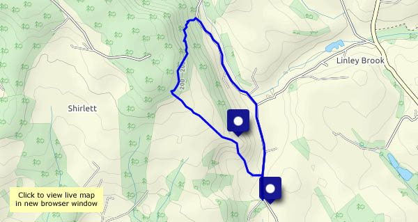
A very short (2.3 miles) and pleasantly shady walk – it’s warm and sunny! – up the leafy track past Round Hill to the Shirlett plateau, and down again through the forested hillside. Is that rustling a blackbird? No, it’s a small deer, perhaps 2-3 metres away, fairly well hidden – so no photos – in undergrowth beyond the fence. It’s sensed our presence, and is gone – no hurry, but it’s soon out of sight. We return to the car along the quiet road through the Smithies. Everyone else (perhaps half-a-dozen) is riding a bicycle. Have we missed something?

View OS map on Streetmap http://www.streetmap.co.uk/map.srf?X=367107&Y=297480&A=Y&Z=115

To Atterley

…from Much Wenlock, through leafy lanes and orchards to this hamlet at the end of a very minor road. As well as the road, which we would need to use to continue our wanderings, three public footpaths meet at Atterley (the one we’re on and two others) – but there seems to be no obvious connection between the paths and the road, and the rights of way on the OS map don’t correspond with the signing around the settlement. A kind and helpful young lady pointed us in the right direction – “you’re not the first I’ve had to help”, or words to that effect…
Heading back, a long straight lane takes us to towards Callaughton, then we head across the fields (with the oilseed rape towering above us) and down another leafy lane to return to Wenlock. An interesting and most enjoyable walk!

View OS map on Streetmap http://www.streetmap.co.uk/map.srf?X=362765&Y=298325&A=Y&Z=120

A change of scene

We’re walking past Hurst Farm pools, then across the field to Shore Pool, where there are bluebells in the woods. The estate road takes us up past the house at Aldenham Park, and soon after, we’ve closed the circle and are heading back past the pools towards the car. We were here just two months ago – what a change! The bare fields are now green – and yellow; the trees are in leaf, and it’s good to be somewhere different. It almost feels like being on holiday, just four miles from home…

View OS map on Streetmap http://www.streetmap.co.uk/map.srf?X=366905&Y=295705&A=Y&Z=120

Vernal equinox

Or was it yesterday? Whichever, we’re at the start of the lighter and warmer half of the year, and next weekend, the clocks go forward (at last!). The plants in hedgerow, forest and field are certainly springing into life and flower, with total disregard for any dodgy viruses the human race may be affected by. The wind (from the east) is chilly, and the sunshine less bright than forecast, but it’s good to be out on Wenlock Edge.

View OS map on Streetmap http://www.streetmap.co.uk/map.srf?X=361530&Y=300385&A=Y&Z=120

To Sheinton, Harley, Wigwig and Homer

A walk from the centre of Much Wenlock, down into the quiet countryside and curiously-named hamlets below the Edge. There are wild deer roaming the fields near Belswardine, and outside Harley church, there’s a comfortable wooden bench, warmed by the sunshine – a perfect place for lunch! The part-time ford at Wigwig is in water today, and the field above Homer is a bit slippery, but we’re soon past the worst as we enter the woods for the remaining stroll back to Wenlock. It’s been a perfect early spring day.

View OS map on Streetmap https://www.streetmap.co.uk/map.srf?X=361305&Y=301955&A=Y&Z=120

Harnage Grange and Kenley

We’re walking along very quiet roads (one car per mile?) in the country below the Wenlock Edge. The ground is drying, but there’s been some heavy rain overnight, and the fields look very soggy in places. The afternoon is gradually improving – by the end, the sun is picking out details here and there in the landscape. Walking along Kenley ridge would be a scenic highlight, if we could see through the hedges (the camera can do it – poked through a gap…). An enjoyable little outing!

View OS map on Streetmap http://www.streetmap.co.uk/map.srf?X=356695&Y=301410&A=Y&Z=120