Benthall: it’s almost bluebell time

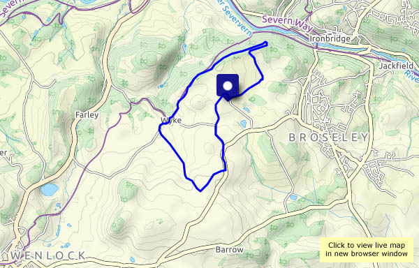
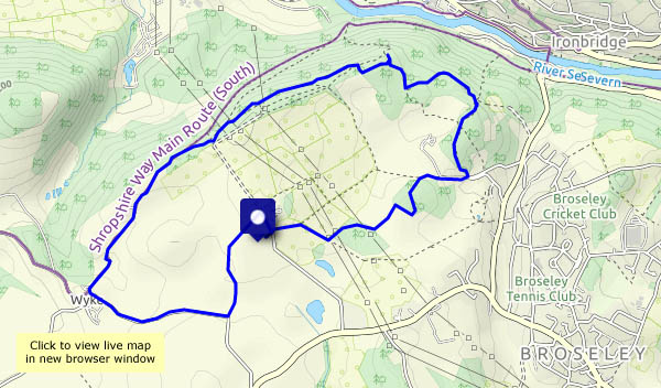
After yesterday’s unbroken blue, today the skies are cloudier – white fluffy cumulus, big enough eventually for (happily, on our short journey home) a few spots of rain. Let’s park at Benthall Hall, and check out the bluebell woods. It’s a bit early for them, but there should be a few in flower.
Moving on from the bluebells, we stop for a moment to watch something scurrying in the undergrowth – some rustling, some twitching vegetation and two or three very brief glimpses of a small furry body. A mouse? A vole? Hard to say – it’s not keen on being studied. We continue via Workhouse Coppice to Benthall Edge, which we follow as far as Wyke, returning to the hall by the quiet lane and the fields.

View OS map on Streetmap http://www.streetmap.co.uk/map?X=365860&Y=302695&A=Y&Z=120

Blue sky, Brown Clee

Not a cloud in the sky! The sunshine is lovely; the air’s still cool – perfect weather for a walk. Not perfect for photography – a few puffy white clouds, or some wispy cirrus would have been good, and it’s hazy. Mustn’t complain – it’s really pleasant up here – almost no-one else about. The highest hill in the county, and it’s all ours this afternoon!

View OS map on Streetmap http://www.streetmap.co.uk/map?X=359830&Y=285880&A=Y&Z=120

Astley Abbotts and the river

Mostly quiet ways on the west bank of the Severn: out via Astley Abbotts, then via Colemore Green to the river bank. The old railway track is busy with bicycles, but we’re not on it for long, and it’s quiet again as we climb up through Chestnut Coppice and back to the start.

View OS map on Streetmap http://www.streetmap.co.uk/map?X=371000&Y=296755&A=Y&Z=120

Cardington and the Battle Stones

Back to the hills! A beautiful sunny afternoon again. The air’s cool but there’s no wind – it’s great to be out on the hills near Church Stretton, on a circular walk from Cardington. We follow the usual route through Willstone towards Caer Caradoc, but instead of continuing towards that popular summit, we turn to the left and head for the rocky turret of the Battle Stones on the edge of Willstone Hill. The views towards to north Shropshire plain are extensive, so it’s a good place for chocolate. Completing the circle (it’s more like a rectangle), we’ll visit the Sharpstones – an unlikely little rocky ridge in a field – and look back on our route.

View OS map on Streetmap http://www.streetmap.co.uk/map?X=349535&Y=294635&A=Y&Z=120

.

Wyke and Benthall Edge

A circular walk from  Benthall Hall. The NT car park is busy (and noisy!), but once we’re into the fields it’s a different world. The sky’s a deep blue today, with puffy white clouds (how do they stay up there? They looks so solid!). As we walk up the lane to the Vineyards, there’s a rustling in the woods, perhaps 30m away. As we stand still and silent, ten fallow deer make their careful way through the trees (the camera would have been busy, but we can barely see them. I’m sure they can see us!). Beyond, the path through the trees along Benthall Edge is pleasant, the sunlight picking out the bright green of new leaves.

View OS map on Streetmap http://www.streetmap.co.uk/map?X=365320&Y=301835&A=Y&Z=120

Coundmoor Brook and Harnage

Just cross the road from Cound’s Guildhall and we’re in the fields beside the brook, which today is truly babbling, the water sparkling in the sunshine. We leave the brook to cut across the edge of the woods and over to Harnage, where we’re spoilt for choice – far more footpaths than we need! The quiet lane takes us back to the Guildhall – we’ll have a look in the charity bookshop before setting off for home.

View OS map on Streetmap http://www.streetmap.co.uk/map?X=355830&Y=304065&A=Y&Z=120

Corvedale ways

Soft hail is pattering on our shoulders as we leave the house – is this outing a mistake? There are showers about, obviously, but once again we succeed in dodging them, until the very last minute of our walk, when a few more soft white blobs descend. Along the old Corvedale road, we’re following a chattery group of walkers, but after pausing at Tigger’s Ickle Shop, they continue along Rowe Lane. We turn away from the lane, to pass Thonglands – now all we can hear is curlews in the fields. Much better!

View OS map on Streetmap http://www.streetmap.co.uk/map?X=354175&Y=288190&A=Y&Z=120