Jonathan’s and Town Brook

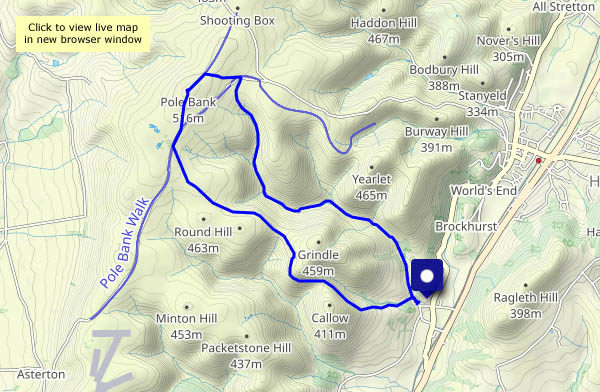
A walk from, but not in, the Carding Mill Valley. Once parked, I’m away back out of the valley, taking the path to Cwm Dale to reach the Batch Valley. At its head, the latter splits – into Long Batch, and Jonathan’s Hollow which takes me up to the Long Mynd plateau. I’ll stop for lunch at the froggy pond near the junction with the direct path from the Carding Mill. Pond? It’s a mere puddle! We’ve had a little rain in the last week or so – what was it like in August? I hope the frogs are OK!
Lunch over, I’ll continue to the top, Pole Bank, where there are just two people, one oblivious to everything but his smartphone, his companion engaged in a loud phone call: “I’m on a hill…” I won’t stay (I was here just last week after all) – I’ll head for the heather-clad ridge leading to the top of Town Brook Valley, then follow its narrow path down towards Church Stretton – and there’s a car in Carding Mill Valley…

View OS map on Streetmap http://www.streetmap.co.uk/map?X=343790&Y=295235&A=Y&Z=120

Lunch at Pole Bank

Yesterday the forecast suggested a mostly sunny ‘lunch out’ day, but this morning it was less hopeful – it would cloud up later, with rain on the way. It was certainly very pleasant on the way to Pole Bank, beside the aptly named Small Batch, and I enjoyed my lunch near the highest point of the Long Mynd. But as I gaze out across the lonely country around Bishop’s Castle and Heath Mynd, the cloud is gathering, and with the possibility of thunder, I’ll head back. The Ashes Hollow is too good to hurry, of course, and it stayed dry. The first drops were falling twenty minutes later as I neared home, dry in the car.

View OS map on Streetmap http://www.streetmap.co.uk/map?X=343360&Y=293180&A=Y&Z=120

Hazy day on Brown Clee

It may have been hazy – no wonderful views of the Welsh heights – but it was very pleasant on this warm early-September afternoon. Quiet too – just three other people. The heather is still in bloom; the gorse is yellow, there are red rowan berries galore. What more can one ask? (An ice cream van at the top maybe? Perish the thought!)

View OS map on Streetmap http://www.streetmap.co.uk/map?X=360080&Y=285960&A=Y&Z=120

Wandering around Cound

Before we can wander anywhere, we must visit the bookshop – we need to top up, and it’s raining! It wasn’t supposed to; it was just a shower and soon past. The season is moving rapidly – it’s clearly a good year for hops, most of the crops have been harvested, and there’s no shortage of hedgerow fruits

View OS map on Streetmap http://www.streetmap.co.uk/map?X=355910&Y=304165&A=Y&Z=120

No rain in Rowe Lane?

There are a few mostly light showers around this afternoon – spots in the wind as we set out, better carry the waterproofs… Inevitably, it stays dry until, perhaps 2/3 of the way round, we stop for chocolate – there’s a very convenient bench, with an excellent view, in Holdgate churchyard. More than just a few spots? We’ll have a look inside the ancient church (it’s well worth a look), and when we leave, the rain has gone (and the ground is dry – it can’t have been much). A little further down the lane, there’s a wonderful patch of blackberries – some of the biggest we’ve seen growing wild, and plenty of them. We’d have been home earlier, and hungrier, if they’d not been there…


View OS map on Streetmap http://www.streetmap.co.uk/map?X=356005&Y=289605&A=Y&Z=120

Westhope wandering

We’re at the far end of Wenlock Edge, wandering down the lane to Westhope (where the blackberries are truly splendid), and onward to the foot of Flounder’s Folly. We’re not going up to the tower today – the highest point of the Wenlock Edge is a wonderful viewpoint, but not ideal for a good circular walk. Instead, we’ll walk back to the start through the woodlands along the western edge. With a steep drop through the trees to our left, and pleasantly open woods to our right, it’s an enjoyable walk – and interesting things lurk in the undergrowth…

View OS map on Streetmap http://www.streetmap.co.uk/map.srf?X=346815&Y=286575&A=Y&Z=120