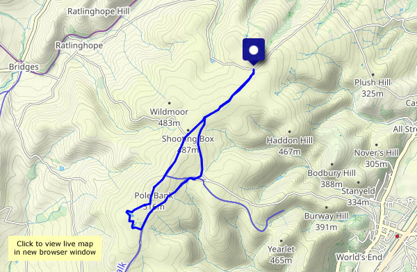
Needed it! I spent most of yesterday travelling, a 300-mile journey entirely by public transport (plus a couple of short walks). The day’s passing quickly – I’d better get on with it! A short circular’s sufficient to clear away the cobwebs.
Category: Shropshire hills
Wandering around Cound
Before we can wander anywhere, we must visit the bookshop – we need to top up, and it’s raining! It wasn’t supposed to; it was just a shower and soon past. The season is moving rapidly – it’s clearly a good year for hops, most of the crops have been harvested, and there’s no shortage of hedgerow fruits
View OS map on Streetmap http://www.streetmap.co.uk/map?X=355910&Y=304165&A=Y&Z=120
No rain in Rowe Lane?
There are a few mostly light showers around this afternoon – spots in the wind as we set out, better carry the waterproofs… Inevitably, it stays dry until, perhaps 2/3 of the way round, we stop for chocolate – there’s a very convenient bench, with an excellent view, in Holdgate churchyard. More than just a few spots? We’ll have a look inside the ancient church (it’s well worth a look), and when we leave, the rain has gone (and the ground is dry – it can’t have been much). A little further down the lane, there’s a wonderful patch of blackberries – some of the biggest we’ve seen growing wild, and plenty of them. We’d have been home earlier, and hungrier, if they’d not been there…
View OS map on Streetmap http://www.streetmap.co.uk/map?X=356005&Y=289605&A=Y&Z=120
The old railway and the riverbank
Down through Chestnut Coppice to the trackbed, south towards Bridgnorth, then back along the riverbank and up the side valley to Colemore Green. A very pleasant outing on a bright and breezy afternoon!
View OS map on Streetmap http://www.streetmap.co.uk/map?X=371720&Y=296420&A=Y&Z=120
Westhope wandering
We’re at the far end of Wenlock Edge, wandering down the lane to Westhope (where the blackberries are truly splendid), and onward to the foot of Flounder’s Folly. We’re not going up to the tower today – the highest point of the Wenlock Edge is a wonderful viewpoint, but not ideal for a good circular walk. Instead, we’ll walk back to the start through the woodlands along the western edge. With a steep drop through the trees to our left, and pleasantly open woods to our right, it’s an enjoyable walk – and interesting things lurk in the undergrowth…
View OS map on Streetmap http://www.streetmap.co.uk/map.srf?X=346815&Y=286575&A=Y&Z=120
To the woods!
What better place, on a grey day! Comer Woods have become popular – there are quite a few other cars parked. Woodland is very absorbent however – we pass just three other people on our four-mile circuit. Towards the end of the walk, when the path nears the main road, there’s some traffic noise – otherwise, there’s just birdsong, an odd light aircraft – and the occasional tooting and chuffing of trains on the Severn Valley Railway, out of sight but well within earshot. We like Comer Woods!
View OS map on Streetmap http://www.streetmap.co.uk/map?X=374740&Y=289495&A=Y&Z=120
Late summer
We’re wandering from Benthall Hall, to Posenhall, Wyke and the woods of Benthall Edge. The colours of spring and early summer are mostly gone, being replaced by the gradually appearing autumnal tints.
View OS map on Streetmap http://www.streetmap.co.uk/map?X=365745&Y=302590&A=Y&Z=120
Cooler

View OS map in Streetmap http://www.streetmap.co.uk/map.srf?X=367470&Y=298250&A=Y&Z=120
The Ice House
“A restored brick structure, once thought to be an ice-house, but more likely used for storage” – so says the website of ‘The Nine Men of Madeley project’. It’s all that remains of Madeley Wood Hall, demolished around 100 years ago. Whatever it is or was, it’s an interesting destination for a walk on this very warm morning. Ice house? An ice cream would have made the morning perfect…
Nine Men of Madeley Project: Madeley Wood Hall
View OS map on Streetmap http://www.streetmap.co.uk/map?X=368695&Y=302995&A=Y&Z=120
Weird woodland
… a warm evening on Wenlock Edge. Perhaps it’s the heat? Things are not normal in the woods near Stokes’s Barn.
View OS map on Streetmap http://www.streetmap.co.uk/map?X=360695&Y=299405&A=Y&Z=120


