Coalbrookdale too! It’s going to rain in the early afternoon – we’ll try to make the most of some brightness before lunch.


View OS map on Streetmap http://www.streetmap.co.uk/map?X=367310&Y=303895&A=Y&Z=120

Coalbrookdale too! It’s going to rain in the early afternoon – we’ll try to make the most of some brightness before lunch.
View OS map on Streetmap http://www.streetmap.co.uk/map?X=367310&Y=303895&A=Y&Z=120
Monday: we’re walking down through Chestnut Coppice to the riverbank and the old railway track. There may be some attractive autumn colours – and maybe an interesting toadstool or two? Yes to both – though the most colourful leaves are on the highly-invasive knotweed which is rapidly colonising the riverbank.


View OS map on Streetmap http://www.streetmap.co.uk/map?X=371965&Y=296515&A=Y&Z=120
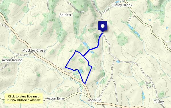
It’s the 1st today. It feels like October too – not overly warm in the sunshine, cool when the sun’s behind a cloud, and a stiff breeze. One or two showers about, but not enough to spoil the afternoon. Altogether pleasant for a wander along the quiet lanes around Harnage Grange and Kenley…


View OS map on Streetmap http://www.streetmap.co.uk/map.srf?X=356695&Y=301410&A=Y&Z=120
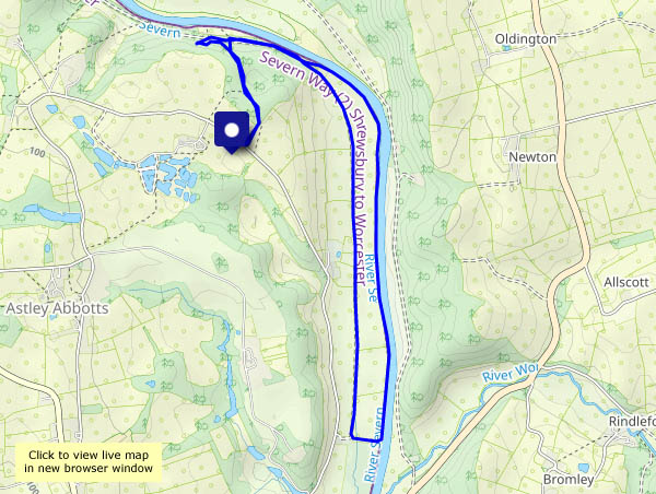
We’re walking from Bedlam to cross the Severn at Ironbridge, then down the old GWR railway track to Coalport. After crossing the bridge there, we’ll follow the old LNWR railway track as far as Coalport youth hostel. Success! The café is open…
Suitably refreshed, we’ll cross the river twice more – over the footbridge towards the Boat Inn, then back through Jackfield to cross the river one more time…


View OS map on Streetmap http://www.streetmap.co.uk/map?X=368855&Y=302735&A=Y&Z=120
We’ll take waterproofs, just in case. It’s distinctly autumnal today, cool with a chilly breeze, but pleasant when the sun shines.
")


View OS map on Streetmap http://www.streetmap.co.uk/map.srf?X=354860&Y=298485&A=Y&Z=120
Photos from three fairly short local outings – down the lane and back again, a Willey wander and a Cound circular. We’ve been seeking (and finding) fruit for some crab apple jelly. We also found lots of interesting fungi (which most certainly will not be going in the jam, or any other cooking pot…)


")


It’s feeling rather autumnal today, though my outing was blessed with blue skies and sunshine for a time. The harvest is in around Aldenham, the fields now showing stubble or brown earth, the seasonal shade of things to come…


View OS map on Streetmap http://www.streetmap.co.uk/map.srf?X=366905&Y=295650&A=Y&Z=120
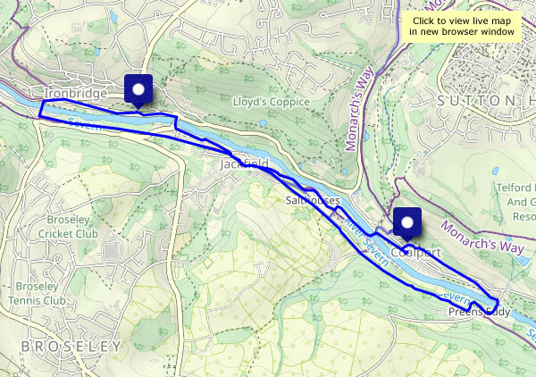
A walk with the camera – down to Ironbridge (busy, as ever), then along the quieter paths away from the main roads as far as the canal at Coalport. I’ll head for home up the dingle – it’s a good way of going uphill without really noticing…


View OS map on Streetmap http://www.streetmap.co.uk/map?X=368220&Y=302280&A=Y&Z=120
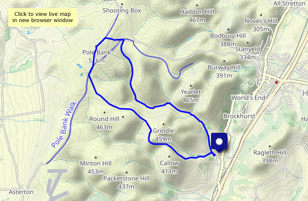
A walk from, but not in, the Carding Mill Valley. Once parked, I’m away back out of the valley, taking the path to Cwm Dale to reach the Batch Valley. At its head, the latter splits – into Long Batch, and Jonathan’s Hollow which takes me up to the Long Mynd plateau. I’ll stop for lunch at the froggy pond near the junction with the direct path from the Carding Mill. Pond? It’s a mere puddle! We’ve had a little rain in the last week or so – what was it like in August? I hope the frogs are OK!
Lunch over, I’ll continue to the top, Pole Bank, where there are just two people, one oblivious to everything but his smartphone, his companion engaged in a loud phone call: “I’m on a hill…” I won’t stay (I was here just last week after all) – I’ll head for the heather-clad ridge leading to the top of Town Brook Valley, then follow its narrow path down towards Church Stretton – and there’s a car in Carding Mill Valley…


")

View OS map on Streetmap http://www.streetmap.co.uk/map?X=343790&Y=295235&A=Y&Z=120
Yesterday the forecast suggested a mostly sunny ‘lunch out’ day, but this morning it was less hopeful – it would cloud up later, with rain on the way. It was certainly very pleasant on the way to Pole Bank, beside the aptly named Small Batch, and I enjoyed my lunch near the highest point of the Long Mynd. But as I gaze out across the lonely country around Bishop’s Castle and Heath Mynd, the cloud is gathering, and with the possibility of thunder, I’ll head back. The Ashes Hollow is too good to hurry, of course, and it stayed dry. The first drops were falling twenty minutes later as I neared home, dry in the car.


View OS map on Streetmap http://www.streetmap.co.uk/map?X=343360&Y=293180&A=Y&Z=120
