A short wander around Attingham Park, on an afternoon of (some) bright sunshine and a cold wind. The walled garden provides a little shelter, and there’s lots of cultivated spring colour. Outside, in the woodlands, there are more natural seasonal highlights, with bluebells and cowslips brightening the shade.
Author: geoffspages
More steam on the main line
Today we’ve been to see the “Welsh Borders Explorer” pass through Shropshire, hauled by Bulleid pacific 34052 “Lord Dowding” (really it’s 34046 “Braunton” in disguise). Here’s a sample; more photos and video at “More Shropshire Main Line Steam” on Geoff’s Rail Diaries.
45212: the Great Britain XI
No, not a football team – it’s the eleventh year this round Britain tour has run. Today the train passed through Shropshire (eventually – it was nearly two and a half hours late, as a result of signalling problems further north), heading for Cardiff via the Central Wales line. As I write this, the train is still moving (I hope) after further delays – it’s due to arrive at about 9.45pm. There are (two) more photos and video on “Geoff’s Rail Diaries” – visit “GBXI: 45212” – now!
April on the Edge
Friday 20th April: It’s too good for indoor chores. Lots of other people had the same idea – the little NT car park was full – though we only saw three others as we walked these quiet fields and woods. Little more than a week ago, it seemed spring would never come, but there’s no doubt now.
View OS map on Streetmap http://www.streetmap.co.uk/map.srf?X=361345&Y=300046&A=Y&Z=120
Spring at last
After lunch, the clouds cleared (as forecast) and instead of rain, warm sunshine fell on Shropshire’s sodden fields. We’d better make the most of it, it may not last… The no 18 bus to Much Wenlock gets us started, on a route which we’ve chosen in the hope of avoiding the worst of the mud (by avoiding field paths, a policy that nearly caught us out on the very quiet road near Wyke). Leaving Benthall Edge (last gasp of the Wenlock Edge) we find ourselves at Benthall Hall, where it’s warm enough to sit outside, in shirt sleeves, for tea and cakes… Suitably refuelled, it’s not far home now.
View OS map on Streetmap http://www.streetmap.co.uk/map.srf?X=365085&Y=301511&A=Y&Z=120
Corbet Wood and Clive
There’s a low sandstone ridge north of Shrewsbury, with attractive woodlands and interesting paved and bedrock tracks. The stone here has been quarried for many years – signs warn walkers to “beware of old quarries”… We’ll follow the lower-level paths from the car park at Corbet Wood, past Grinshill to Clive, then return via the highest point, which is a fine rocky viewpoint for the hills to the south, but hardly what one would call a summit (192m, or about 630ft above sea level). It’s a pleasant walk on an afternoon when, despite the grey skies, there’s spring in the air.
View OS map on Streetmap http://www.streetmap.co.uk/map.srf?X=352040&Y=323791&A=Y&Z=120
Bog, Black Ditch and Black Rhadley
There’s barely a cloud in the blue sky – it’s a day that’s too good to waste. We’re off to The Bog, for a walk along the southern ridge of the Stiperstones to Black Rhadley, and when we get back, the Bog Centre is open for tea and cakes. What more could one ask? That was intended to be a rhetorical question, but I’ll answer it anyway: “peace and quiet” – and yes, we had that too. Despite the weather being unusually good, we saw hardly anyone else on our walk, the shooters at the range were quieter than normal and even the dogs in the kennels failed to disturb the calm (there must have been others about – the cakes had nearly all gone!).
View OS map on Streetmap http://www.streetmap.co.uk/map.srf?X=335045&Y=296846&A=Y&Z=120
Dingles and dereliction
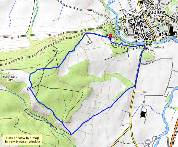
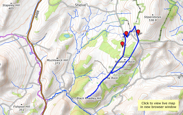
Easter Monday: an exploration of land within two or three miles of home, not normally accessible to the casual explorer. In order gain access, the permission of the various farmers and others had to be sought in advance (many thanks to Myra for doing the – er – groundwork, and to the family for wonderful and timely refreshments).
It’s unbelievably soggy underfoot, following a night of heavy rain (did I mention it’s a bank holiday?) – after seeing the forecasts earlier in the week, we’ve done remarkably well to stay fairly dry. As well as the mud, there are atmospheric remnants of the rain – a general murk and mist in the trees, adding to the melancholy of the sad, abandoned dwellings we encounter, remote from civilisation and “mod cons”. The dingle is a delight – with the added interest of a flow of natural bitumen part-way down the faint path.
The old hall
That’s Moseley Old Hall, near Wolverhampton, an interesting place to explore on a cold and decidedly damp afternoon. Originally half-timbered, it was later encased in brick. King Charles hid here! It’s dark inside – very dark, in places – but we’ll do what we can.
Into the woods
A short walk from Ludlow. We’ve parked facing the well-known view of the town, with the castle and church prominent against the backdrop of Titterstone Clee. A cloud is casting deep shade over the castle, though the rest of the town is floodlit. Perhaps on our return?
Our walk takes us a short way along the old A49, then up to the woodland past Hucksbarn and Starvecrow. There are some fine views on this clear afternoon – until we enter the woods, by which time the cloud has thickened and the sunshine gone. There are thick plantations of conifers at first, but as we descend towards Ludlow the woodland becomes more varied and interesting.
View OS map on Streetmap http://www.streetmap.co.uk/map.srf?X=350060&Y=273470&A=Y&Z=120


