Sunday 21 October: a brief wander around Blists Hill on an afternoon that started sunny. If the sun had continued to shine, we’d have spent longer…


Sunday 21 October: a brief wander around Blists Hill on an afternoon that started sunny. If the sun had continued to shine, we’d have spent longer…
Saturday 20 October: we’re in Yorkshire, exploring after lunch. The ruinous remains of Kirkham Priory stand beside the river Derwent, between York and Malton, and are worth exploring. The York – Scarborough railway passes through the valley on the other side of the river, crossing the minor road by means of a level crossing. It’s controlled by a mechanical signal box, “Kirkham Abbey”: the crossing gates swing out across the road when a train is coming. Kirkham Abbey is a now-rare survivor of a once-common scene.
Photo note: today’s outing wasn’t expected to have photographic opportunities. I took the photos using the smartphone – not the best tool for the job, especially considering the railway is in deep shade, mid-afternoon in late October. We’ll have to revisit…


View OS map on Streetmap http://www.streetmap.co.uk/map.srf?X=473260&Y=465760&A=Y&Z=120
Autumn on Cannock Chase, and the toadstools are in full bloom, so to speak. They’re all over the place – there’s a magnificent fairy ring in one spot, and there are fly agarics (“Flying Erics” – the red ones with white spots, and a little door for the gnomes) in profusion. Sadly, someone has a grudge against them, and many have been kicked to the ground (who would do such a thing?), but many more have come up to replace the fallen. It’s fun up here at this time of year!


")


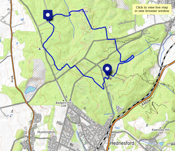
View OS map on Streetmap http://www.streetmap.co.uk/map.srf?X=399490&Y=316371&A=Y&Z=120
It was neither as clear or sunny as we’d hoped, but it was still very pleasant on the Long Mynd this afternoon, and we made it back to the Carding Mill in time for tea and cakes, which meets the criteria for “pretty good outing”, I reckon…


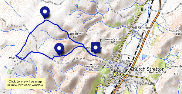
View OS map on Streetmap http://www.streetmap.co.uk/map.srf?X=343100&Y=294861&A=Y&Z=120
…is an old-fashioned little pub in Madeley. Just opposite the Blists Hill museum, it’s a bit of a time capsule in its own right, one of the last of the original home-brew pubs. Within walking distance too, not far off one of our regular routes. So instead of tea and cakes at Coalport, we’ll have lunch at the All Nations. Remarkably, it’s warm enough on this beautiful sunny day to sit outside (we’ll pay for it over the next few days…).
Suitably replete, we’ll follow a wonderful woodland way back to the “Free Bridge”, before rejoining our usual route homewards.


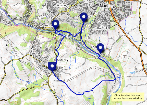
View OS map on Streetmap http://www.streetmap.co.uk/map.srf?X=369270&Y=301836&A=Y&Z=120
Tuesday 9 October: an autumn wander around Attingham Park. The deer are busy with the rut (so we won’t disturb them), the leaves are turning nicely, and the squirrels are out in force making the most of the abundant nuts. There are some interesting fungi too (this is proving to be a recurring theme), though I’ve no idea what they are.


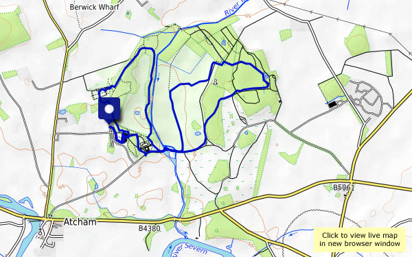
View OS map on Streetmap http://www.streetmap.co.uk/map.srf?X=355235&Y=309991&A=Y&Z=120
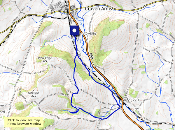
Sunday 7 October: a walk from Stokesay to Aldon Gutter. There are valleys, dales, hollows and batches (and beaches – same thing) in this county. And gutters! They’re all valleys, one way or another; the only difference is perhaps their scale, and if that’s the case, then a gutter must be at the lower end – a fairly minor feature of our varied landscape. Today we’re walking from Stokesay to Aldon Gutter, for no better reason than (a) we’ve never been there before, and (b) it looked inviting on the OS map. It’s a very pleasant, and very quiet walk. The only people we see are the farmers at Aldon, moving their heifers indoors for the coming winter. Aldon Gutter (what a lovely place!) is thickly populated – with pheasants. There are hundreds of them, blissfully ignorant of their ultimate fate in the hands of so-called sportsmen – if, that is, they don’t stray onto the roads nearby.
Only one problem faces us. As we descend towards the Onny, with just a mile to go, the path fades to nothing (dense undergrowth in the woods). There’s no obvious way over the fence… Tricky! (We made it, of course, but a stile would have been good)


View OS map on Streetmap http://www.streetmap.co.uk/map.srf?X=343885&Y=279956&A=Y&Z=120
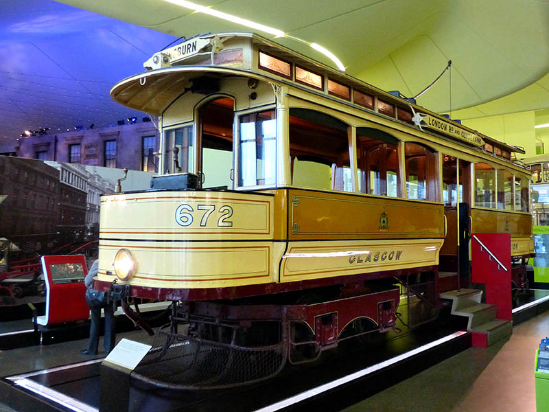 Just published to Geoff’s Rail Diaries, lots of pictures and an account of “a grand day out” by rail to Glasgow and back. Visit “Glasgow: a day out” for the full story.
Wednesday 26 Sept: Up at 6am! We’re catching the 9.09 Pendolino from Crewe; at Carlisle, we’ll join the 11.12 for Glasgow Central – via Dumfries and Kilmarnock (our choice – slow but scenic). We then have a whisker over 3 hours, into which we’ll squeeze
– St Enoch Square – for a look at the old Subway station
– the riverside walk to the Riverside Museum
– a subway ride to Buchanan Street, for a look at Queen Street station
– a walk back to Central station, and
– an expensive (£4.75!) pint…
before heading for home on the 16.40 to Euston. It’s not going to call at Crewe, so we’ll have to change at Lancaster – onto a train that decides to stop at Preston for almost an hour. We’ve no driver – signals problems away down south mean he’s late. So we’re on a later-than-planned train from Crewe back to the car, and at about 10.45pm, I’m home again. Did all of that happen in just one day?
That’s enough for now – a few photos below; more to follow.


It didn’t seem to be especially clear (the Met Office had said “excellent” visibility), but we could make out Pen y Fan in the Brecon Beacons – and, faintly, the mountains to its west – that’s about 60 miles. It’s good up here when the air is cool and clear. There are interesting things close at hand too – fungi in profusion!

")


")
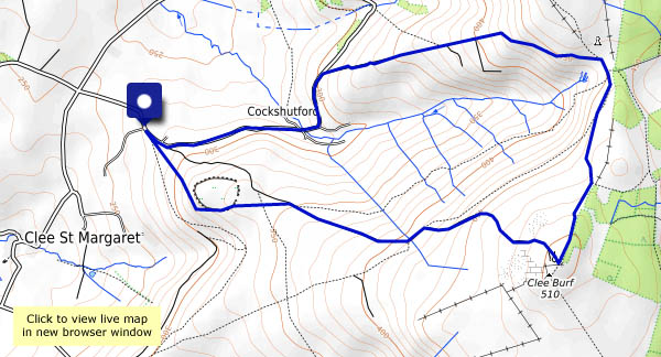
View OS map on Streetmap http://www.streetmap.co.uk/map.srf?X=358350&Y=284861&A=Y&Z=120
