Four bridges…

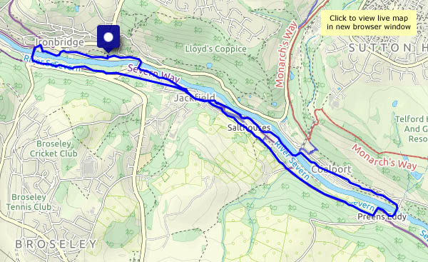
…cross the Severn along a two-mile stretch in the gorge – the Iron Bridge, the (new) ‘free’ bridge, the Coalport memorial footbridge and the Coalport bridge. We’re walking from the car park at Bedlam, upstream to Ironbridge, over the river and down the old Severn Valley railway track to Coalport. Crossing the river again, we walk past the old china works to the memorial footbridge, then back through Jackfield (the door’s open at St Mary’s church – we’ll take a look inside) and over the free bridge back to the car. Apart from a short stretch between Craven Dunnill’s and the level crossing, we can avoid retracing our steps. It’s a pleasant shady walk for a warm afternoon.

View OS map on Streetmap http://www.streetmap.co.uk/map?X=368700&Y=302565&A=Y&Z=120

Harebells and foxgloves

Cardington, Chatwall, Enchmarsh and Willstone – quiet places linked by quiet lanes. Yell Bank, between Chatwall and Enchmarsh, is a little over 1,000ft above sea level, and has two well-placed benches (for picnics, if we’d thought about this walk before lunch, or for chocolate, a welcome alternative). One faces north-west, the other, a little further along, faces south-east. Either way, the views are tremendous, and all along our route, the summer flowers are in abundance.

View OS map on Streetmap http://www.streetmap.co.uk/map?X=350500&Y=296295&A=Y&Z=120

The Belties

There’s a small herd of belted Galloway cattle near Round Hill – though with several fields to choose from, they’re not always visible to passers-by. Today they’re in the field by the road, the one with the tree full of mistletoe – and it looks like their numbers have grown recently. We’ll take a few photos – but our hopes that the youngster will look up are in vain. Perhaps on our way back?

We continue up the narrowing track past Round Hill, and down Ned’s Lane, to return to the start along the increasingly undriveable road (could lose a small child in some of the potholes) back to the car. Glancing into the belties’ field – they’ve  gone! Wandered off to pastures new…

View OS map on Streetmap http://www.streetmap.co.uk/map.srf?X=367107&Y=297480&A=Y&Z=115

Close

That’s a description of the weather, and the photography… We’re walking around the lanes near Willey – after a rainy morning, the afternoon is warm, humid and mostly dry, just a few spots as we pass Lower Pool. We’re under the trees anyway, but the raindrops are speckling the otherwise still waters.

View OS map on Streetmap http://www.streetmap.co.uk/map.srf?X=367620&Y=297945&A=Y&Z=120