Pyramids

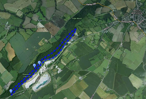
Orchids – little conical-topped ones – dozens and dozens of them. And one solitary (greater?) butterfly orchid (they’re not common). We’re walking on Wenlock Edge, the same route we followed on a misty day in February (see “A hazy day on Wenlock Edge“). It’s virtually midsummer now – no mist today, instead there’s warm sunshine, and it’s pleasant in the cool shade under the trees.

The map below is the one used in February:
today we walked clockwise – out below the edge, back along it.

MapView OS map on Streetmap http://www.streetmap.co.uk/map.srf?X=359285&Y=298596&A=Y&Z=120

Coal Trains

Colin and the coal trucks

We’ve been to Chasewater this afternoon, for their “Coal Trains Day” event (what better way to celebrate the solstice?). Red (No 2), green (Colin McAndrew) and blue (Holly Bank No 3) steam locos in action on the self-styled “Colliery Line” – great fun! For more on the day’s activities – and more pictures – visit “Coal Trains Day” on Geoff’s Rail Diaries.

Sheinton to Harley, Wigwig and Homer

Life under the edge

There’s many a double-take by passing motorists on the Shrewsbury – Wenlock road – “Did that sign really point the way to Wigwig and Homer?”. Yes, a hamlet and a small village well-hidden, despite the sign, beneath the northern end of the Wenlock Edge. This was a very pleasant circuit, starting from Sheinton, following farm lanes and tracks past Belswardyne Hall to Harley. “Look at that – the sun’s got a halo”. There’s no need to enter quiet Harley village, and it means crossing the busy A458 twice – but it saves walking beside the noisy road. The lane to Wigwig crosses what was once a ford, and probably still is in very wet weather. In Homer, we leave the road and take to fields of sheep, followed by attractive woodland beside Sheinton brook, then more fields of sheep – and we’re back in Sheinton.

Map

View OS map on Streetmap http://www.streetmap.co.uk/map.srf?X=361005&Y=302661&A=Y&Z=120

New town park

Monday – a walk into Telford Town Park. We started from the southernmost tip, close by the aqueduct, to walk nearly two miles mostly along and beside the old Coalport railway trackbed to the town centre. The paths are well made (there was a lot of rain on Saturday…), many and varied – quite a maze as we near the offices, shops and restaurants. The railway followed the route of an old canal, still evident in places, providing a pleasant and varied landscape in the “wild” park. It’s much tamer close by the town centre, and there are many more people. It’s good to turn and head back past the tall Stirchley chimney to the relative quiet of the railway cutting, a long cool hollow on this warm afternoon.

View OS map on Streetmap http://www.streetmap.co.uk/map.srf?X=369850&Y=307441&A=Y&Z=120

On the border

Llanthony Priory to Cwmyoy – a walk in the Black Mountains:

We’ve done this one before – a circular walk in the easternmost valley of the hill country north of Abergavenny, following the valley of the Honddu from Llanthony to Cwmyoy, then up onto the ridge to walk along the border between England and Wales. The valley walk is pleasant and quiet, following woodland paths. Cwmyoy is best known for its church, built on unstable ground. The ridge is high and airy – it may be June, but there’s a cold wind – best keep moving…

Map

View OS map on Streetmap http://www.streetmap.co.uk/map.srf?X=329335&Y=226033&A=Y&Z=120

Narrow gauge heaven

Sragi No 1 and CSR 19 bustle along with a passenger train

It’s the Statfold June open day – and, as ever, there are narrow gauge steam locomotives everywhere. One on each end of the two trains on the new line, lots more on the old line – the freight has no fewer than four locomotives, two at each end. Haven’t attempted to count them – perhaps if I can’t get to sleep tonight (better than sheep…). A “Rail Diaries” page will appear in a day or two – in the meantime, here’s just one taster.

Two sunny afternoons

They’re too good to waste! Bright sunshine, fluffy clouds, not too warm – ideal for wandering.

Wednesday: To Benthall Edge and Hall (tea and cake)

Thursday: Long Mynd. A route we’ve done many times, starting from the Cardingmill valley and ascending via the Lightspout (hoardes of schoolchildren – it’s peak field trip season). Beyond the waterfall it’s quiet – just the sheep and the hill ponies to accompany us to Pole Bank. We return along the ridge to Townbrook Valley, a pleasant path to take us back to the start.

Map

View OS map on Streetmap http://www.streetmap.co.uk/map.srf?X=343005&Y=294546&A=Y&Z=120