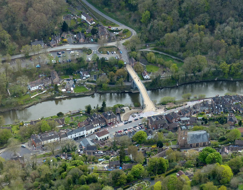
…and Jackfield, Madeley and Ironbridge. The sky is clear blue, but the temperature is barely above freezing and there’s a stiff northerly breeze. The sheltered valley and south-facing slopes might be the best places to aim for, and there’s plenty of interest on this short leg-stretch.
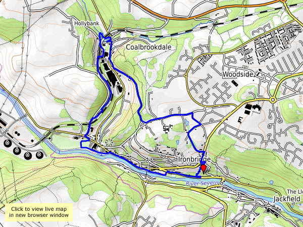
The remains of the ancient iron furnaces at Bedlam were open to the elements until very recently – now they have a cover – a canopy with substantial steel supports. We’d better take a look. Afterwards, we’ll wander over the hill, and down Church Road, viewing the closed power station through the trees (there’s a common theme to this little walk…). At the top end of Coalbrookdale the viaduct no longer serves its purpose. The woodland path to the old railway station, now in the care of the Green Wood Centre, overlooks the iron works, soon to cease production. It’s been a quiet walk so far, but now we’re dodging the many visitors to Ironbridge as we walk beside the river back to the car. At least one thing is still thriving here.
Keeping the legs well-stretched – a walk down to Ironbridge and back, to have a closer look at the work going on at Bedlam furnaces and the bridge itself. Tea and cake too!
We’re walking down to Ironbridge this afternoon, past some of the sculptures which once stood at the power station (now closed). If we follow the paths through Workhouse Coppice we can then descend through the woods to the bridge. The busy Wharfage takes us to the antiques centre (one of us is looking for a gift – the purpose of this little outing), then we’ll head back to Broseley up the steep Bridge Road. We’ll have to shelter from the rain first – there are one or two showers about…
Shropshire was once noted for its damsons – they seem to grow everywhere. One of the saddest sights is the windfalls rotting in the gutters. Few people seem to want them today – what a shame!
We’ve walked to Ironbridge (easy – downhill!) for lunch. Now we have to pay for it – with a most enjoyable walk back up through the woods and across the fields. It was supposed to be overcast today, but the weather wasn’t paying attention to any forecasts.
Sunday 24 April 2016: let’s step back just over 12 months: “He’s sent us vouchers for a helicopter trip!”. The facial expression said it all – I think she nearly took flight there and then… With a busy summer ahead and lots of unknowns, we didn’t get round to redeeming them until the autumn. The first booking was cancelled due to the weather – as was the second, and the third, and… (it’s reassuring really). Eventually, we made it, and with plenty of time to get used to the idea, “we” were quite looking forward to the flight. “Is that it? It’s tiny!”. Yes, a very modern-looking (I’m no expert) little four-seater job – driver and three passengers.
We’re flying from Halfpenny Green – “Wolverhampton Airport”, though its WW2 origins are still pretty obvious. We’re strapped in (car-type seat belts) in minutes and away – and despite the clattering of rotor blades while we waited to board, it’s quiet and peaceful (thanks partly to the headphones, I guess) – a very relaxing way to travel over the Shropshire countryside, bobbing and swaying gently in the breeze, with little sense of forward motion. First we’re heading for Bridgnorth, then turning to fly above the Severn, passing Stanley Hall, the fishing lakes at The Boldings and Apley Hall. Soon Broseley is over to our left, and in moments we’re above Ironbridge. As we pass the power station, we begin to turn back, viewing the huge bends upstream in the Severn before buzzing Benthall Hall and skirting Broseley again. Staying west of the river, we’re soon looking down on Bridgnorth, then Chelmarsh reservoir and, crossing the river, Dudmaston Hall. Not far to go now – losing height again to make a gentle landing back at Halfpenny Green. What a great trip! Many, many thanks, T. “When can we go again?” ‘Nuff said!
Thursday: another fine day. “Let’s walk down to Ironbridge for lunch”. Sounds a good idea to me – and we can walk it off again on the way back – it’s uphill all the way, and a longer route… Very pleasant (the lunch and the walk) – perfect!
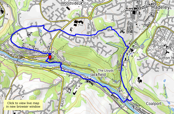
Monday: We’ve taken the bus to Telford town centre, and we’re walking back. For roughly half the distance (just over 6 miles in total) we’re on, or close to, the Silkin Way, which follows the track of the old Coalport railway. In places, its predecessor, the canal, is also still in water. We leave the trackbed of necessity – there’s a gap, where it used to cross the railway to Ironbridge power station – both now out of use. From this point (near to the old windmill), we’re roughly parallel to the Ironbridge line, and as we descend from Lightmoor, we join the track of an older way – one of the many pre-railway age tramways that ran in these parts. Arriving in Ironbridge, there’s time for tea and cake…
We’re heading for Coalbrookdale, using a path we haven’t walked before (old maps show a pre-railway age tramway following the same route) to descend from Broseley’s maypole towards the new free bridge, a modern silver-painted steel structure half a mile downriver from its more famous cousin. A ruddy stream betrays the content of the hillside, a reminder of why it all happened around here, some 250 years ago. When we reach Darby’s coke hearth, at the top of the dale, we’ll head for home – pausing only for tea and scones beside the Severn…


")