Cool and clear on Clee Burf

It didn’t seem to be especially clear (the Met Office had said “excellent” visibility), but we could make out Pen y Fan in the Brecon Beacons – and, faintly, the mountains to its west – that’s about 60 miles. It’s good up here when the air is cool and clear. There are interesting things close at hand too – fungi in profusion!

View OS map on Streetmap http://www.streetmap.co.uk/map.srf?X=358350&Y=284861&A=Y&Z=120

Blue Clee

The bluebells are out with a vengeance on the lower slopes. The sky’s blue (with puffy white clouds, and the distant hills are blue (remembered…). And there’s hardly anyone else out (were there a couple of matches going on today?). A cuckoo makes its presence felt, and just off the north end of the hill, there’s a pair of red kites wheeling and diving. It’s good up here – shame to have to come down again.

View OS map on Streetmap http://www.streetmap.co.uk/map.srf?X=360190&Y=285771&A=Y&Z=120

Brown Clee in May

…via the Burwarton estate road and Boyne Water. On a day like this, it’s against the law to stay in, apparently. Everywhere will be busy; Brown Clee might be quieter than places with ice cream vans and tea rooms? It probably was, though there were lots of cars parked where usually there might be one or two others. We didn’t see many of their occupants – perhaps ten in total. It’s quiet here – just the odd lark (ascending), hardly a breach of the peace. It’s warm too (jackets and jumpers not required – at last!), with a pleasant light breeze, and though the sky is clear the air isn’t – this is not a day for extensive views. Nevertheless, it’s a great place to be on such an afternoon.

View OS map on Streetmap http://www.streetmap.co.uk/map.srf?X=360215&Y=285696&A=Y&Z=120

Cold Clee

Friday 24 November: It’s cold up here today – the frost is lingering in the hollows – but the sunshine (wall-to-wall!) is warm, and a picnic lunch on the rocks near the summit of Clee Burf will be just the thing. We’ve got to get there first, and we’re trying a new route, up the edge of the access land near Stoke Enclosure. It’s a good route too – until we reach the summit plateau. We have to cross deeply tussocky grassland, and there’s no path – and the gaps between the tussocks are very wet… Lunch over, we’re not going to hang around – it’s too cold, but not too cold for a chocolate stop at the well-placed wooden seat. It’s downhill from here…

View OS map on Streetmap http://www.streetmap.co.uk/map.srf?X=358635&Y=284841&A=Y&Z=120

Parasols and sombreros on Brown Clee

Not just parasols (one of which looks more like a sombrero), though their size makes them rather obvious – there are all kinds of fungi up on Brown Clee at this time of year, from the mundane to the weird and wonderful. It’s a very pleasant afternoon to be out on the hill – barely a breeze at first, with a blue sky and white fluffy clouds. Later, the sunshine becomes rather watery, but it stays dry, and the light’s just right for those monster mushrooms as we return to the car.

View OS map on Streetmap http://www.streetmap.co.uk/map.srf?X=358940&Y=285446&A=Y&Z=120

Grey sky, red kite, Brown Clee

The sky may be uninspiring, but it’s a fresh-feeling afternoon, and the weather forecast thinks it should stay dry. A track follows the contours around the northern part of Brown Clee – we’ll join it at its northernmost point and follow it round to the west, then walk over the top of the hill and down the other side. We can then use the eastern arm of the track to get back to the start. A red kite is overhead briefly; sheep are everywhere, but there’s no-one else to be seen today. Do they know something we don’t, or is it the other way round?

View OS map on Streetmap http://www.streetmap.co.uk/map.srf?X=359685&Y=286976&A=Y&Z=120

Bright and breezy: Brown Clee

Cool, too, in the wind. The east side of the hill is in the lee, and the walk is very pleasant through the parkland, warm in the sunshine with views improving as we gain height. Boyne Water is twinkling as the breeze lifts wavelets; a little further on, we’re out on the ridge. Now we have extensive views to the west, but we’re in the wind, and we need to keep going. It buffets the camera as we stand at the highest point. Moments later, as we begin to descend, we’re sheltered and it’s a warm spring afternoon once more.

View OS map on Streetmap http://www.streetmap.co.uk/map.srf?X=359885&Y=285911&A=Y&Z=120

Brown Clee skyscapes

The sky’s blue today, with photogenic clouds (best kind) – let’s have a walk on Brown Clee! We’ll walk up from the telephone box (it’s a free library these days) and take the terrace path around the hill to the far side. At first on the open hillside, it later skirts the forest, where there’s some attractive deciduous woodland beside the conifers. When we meet the path up the east side, from the picnic place, we make a gentle and cautious (it’s a bit sticky underfoot) ascent to the summit where, for a few minutes, we’re the highest people in Shropshire. It’s downhill from here, of course, but no-one has told the water – the moor is rather squelchy. But who cares? It’s great up here on a day like this.

Soon we’re back at the car – better change the library books before we head for home…

map

View OS map on Streetmap http://www.streetmap.co.uk/map.srf?X=359115&Y=286916&A=Y&Z=115

Longer days ahead

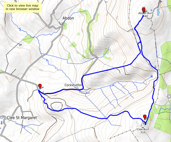
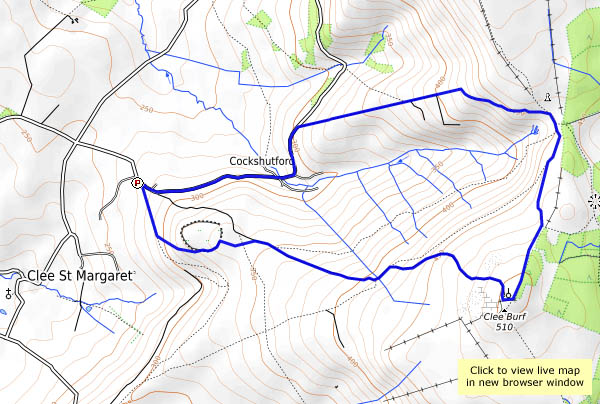
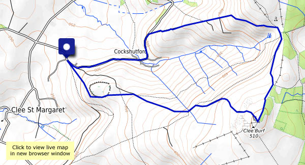
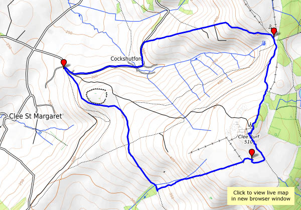
22 December: We’re past the shortest day now, though it will be weeks before the evenings become noticeably lighter. It’s a fine and breezy afternoon – a last chance for a good leg stretch before the weather deteriorates and the Christmas fun begins. Brown Clee beckons!

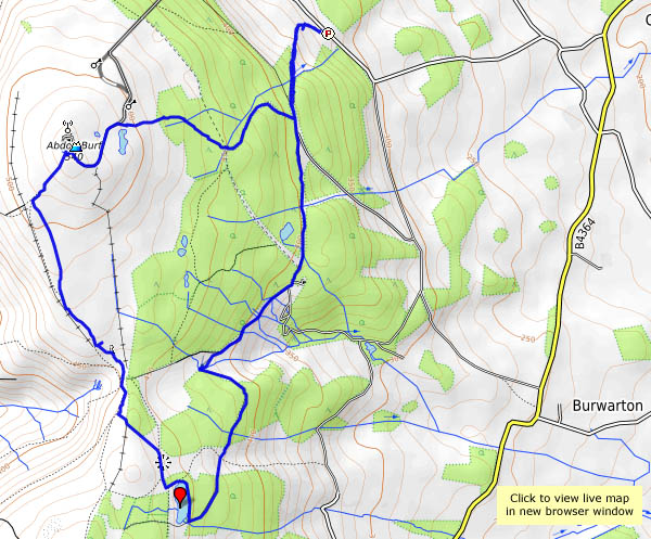
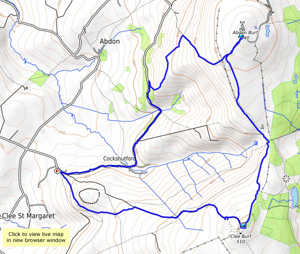
As ever, it’s quiet up here. Just as I leave the car, two families arrive, but I’m away, and won’t see them again. Other than a solitary photographer at the highest point, I’ve got the hills to myself (and the sheep, and a couple of small groups of wild horses). The breeze stiffens at Clee Burf, the secondary summit, but it’s quiet enough at the seat above the five springs for a lunch break.

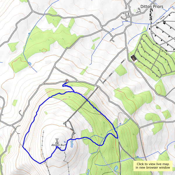
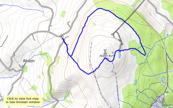
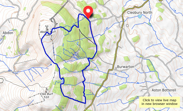
I’m off again, following a soggy path to the summit at Abdon Burf, and for a few seconds (the wind is cold here) I’m the highest person in Shropshire. I’ll return to Cockshutford down the track towards the telephone box, before taking the contouring path back to the lane. There’s a glimpse of a red kite for a few moments, but try as I might, I won’t see him again. Until the next time, perhaps…

map

View OS map on Streetmap http://www.streetmap.co.uk/map.srf?X=358625&Y=285576&A=Y&Z=120

November on Clee Burf

There’s a stiff breeze, but it’s too good to stay in – we’ll walk up to Clee Burf, the southern summit of Brown Clee. Apart from the wind in the trees, it’s quiet up here. There’s no-one else about, apart from a solitary jogger, who doesn’t look happy. No shortage of sheep, of course. The forecast suggested there could be the odd shower, but we’re lucky today – bright sunshine throughout. There’s a big shower cloud to the north, and another, nearer, provides us with an unexpected rainbow. The end of it is just over there – no crocks though, just another sheep – taking on an appropriately golden tint in the late afternoon sunshine.

opentopomap.jpg

View OS map on Streetmap http://www.streetmap.co.uk/map.srf?X=358572&Y=284823&A=Y&Z=120