November mists

Yesterday, I said “November days don’t get much better”. I didn’t know how good today would be. A clear blue sky, no wind, a hard frost – and mist in all the hollows, catching the light and the eye. Later, a bank of thin high cloud drifted across, lending a different feel to the day. What will tomorrow bring? (Fog, according to the Met. Office…)

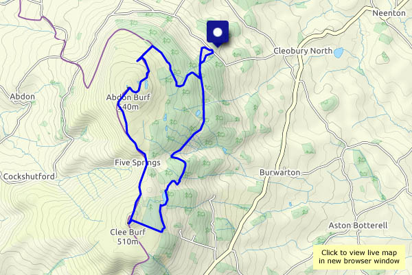
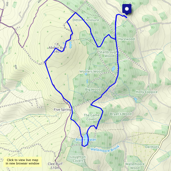
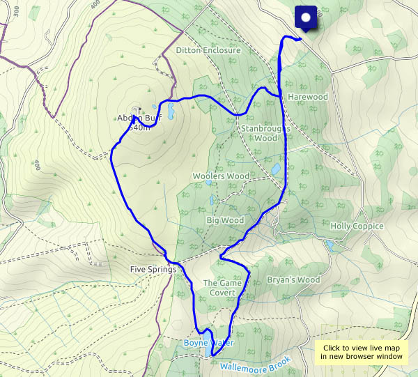
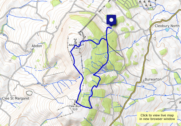
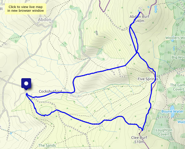
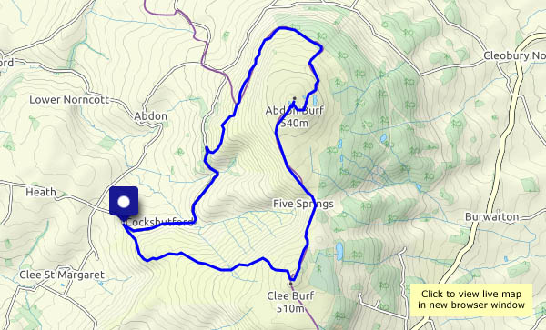
View OS map on Streetmap http://www.streetmap.co.uk/map.srf?X=359920&Y=285640&A=Y&Z=120

Clee breezes

Thursday 22 October: there’s a stiff breeze from the north-west, and the air is cold, but we’ll soon warm up as we walk from Cockshutford, heading for the top of Brown Clee at Abdon Burf. Too cold to hang around! We’ll retrace our steps for a little way to continue along the ridge (though it’s hardly that) to the secondary summit at Clee Burf – and it’s all downhill from here, pausing only to record the presence of some splendid (though not fully-grown) parasol mushrooms below Nordy Bank.

View OS map on Streetmap http://www.streetmap.co.uk/map.srf?X=358970&Y=285485&A=Y&Z=120

The estate road and the terrace

A day on Brown Clee: the weather’s not great – gloomy, cold and just the occasional spot of drizzle – but it’s good to be out on Shropshire’s highest hill. Not a giant, Brown Clee is nevertheless a good viewpoint, and today the air is clear despite the gloom. Higher hills in Wales form a wonderful western panorama – and that summit away in the far south-west must be Carmarthen Fan, a full 100 km distant (just over 62 miles, but it sounds more impressive in metric). Our outward route has taken us along the estate road, then up the steep track to a bench beside Boyne Water. Later, after crossing the summit ridge, we drop down to the hillside terrace, with its views of Corvedale and the Wenlock Edge. A most enjoyable circuit!

View OS map on Streetmap http://www.streetmap.co.uk/map.srf?X=359765&Y=285845&A=Y&Z=120

Clee woodlands

We’re walking on the tame side of Brown Clee – the woodlands on the north-eastern edge of the hill. Once again, the shade is welcome, though there’s a bit more cloud today. The greater part of this route is not over-popular – as we guessed, most of the other people we saw (perhaps a dozen?) were on the short stretch between the picnic field and the summit. For much of the time, we had the place to ourselves.

View OS map on Streetmap http://www.streetmap.co.uk/map.srf?X=360025&Y=286850&A=Y&Z=120

Back to the hills!

A dry day – bright, plenty of sunshine, just a light breeze. It’s been a long time since we were up in the hills. There hasn’t been quite so much rain in the last few days, and if we stick to the forest tracks where possible… We’re back on Brown Clee, and it’s wonderful up here. Yes, there are one or two muddy places, but we can get around them. Yes, it could be clearer – but the views, especially to the west, are truly arcadian. What an enjoyable afternoon!

View OS map on Streetmap https://www.streetmap.co.uk/map.srf?X=359735&Y=286465&A=Y&Z=120

Mist on Brown Clee

Monday 30th December: like Christmas Day, the sky is blue. Unlike Christmas Day, there’s a stiff breeze – and patches of mist blowing around, not enough to be a nuisance, but adding to the enjoyment of this wonderful day on the hills. Remarkably, above the mist, the views are (at times) extensive – there are the Black Mountains – and that’s Pen y Fan, the highest point of the Brecon Beacons, some 55 miles distant. It’s unusually busy up here – we must have seen more than 20 other people. Mostly, they confine their activites to the small area between the summit and the old railway incline – elsewhere, Brown Clee is ours.

View OS map on Streetmap https://www.streetmap.co.uk/map.srf?X=358945&Y=286006&A=Y&Z=120

Early Autumn on Brown Clee

The Met Office’s autumn starts on 1 September – summer’s over! It certainly feels like it today – there’s warm sunshine in-between the clouds, and the lightest of breezes, which is just as well, as the air’s cold. Perfect walking weather, of course, and once we’ve left behind the dog-walkers, there’s hardly anyone else up here. The views to the east are extensive, but unexciting,  as we ascend gently. The views to the west, once we’re on the summit ridge, are also extensive – and much more interesting. Line after line of hills stretching out to the limit of visibility, perhaps 40-50 miles – yes, it could be clearer, but we’re not complaining…

View OS map on Streetmap http://www.streetmap.co.uk/map.srf?X=359855&Y=285941&A=Y&Z=120


Highest in the county

We stood  above everyone else in the county at about 2.45 this afternoon, when we gazed out from Abdon Burf on Brown Clee, Shropshire’s highest point (1772 feet, or 540m). It’s a good place to be on an afternoon like this – positively springlike, it would be a crime to stay indoors. It’s quiet too – despite being school half-term week, we saw just four other people while we walked. Wonderful!

View OS map on Streetmap http://www.streetmap.co.uk/map.srf?X=360130&Y=285861&A=Y&Z=120

Midwinter on Brown Clee

Carpe diem: this kind of midwinter weather is great – dry, bright, mild (with a cool breeze, it has to be said) – a day that must be seized. It’s quiet on the eastern side, as we ascend slowly towards Boyne Water; the breeze is stiffer to the west, but the views are much better and we’re well warmed-up. From time to time the sun shines strongly through gaps in the cloud – these are truly “photoflood days”. It’s too good to come down again, but the cloud’s building and the day is fading – we’d better head back.

View OS map on Streetmap http://www.streetmap.co.uk/map.srf?X=359760&Y=285676&A=Y&Z=120