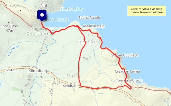
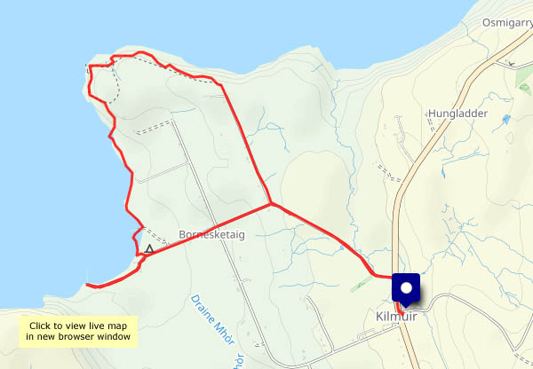
A Haughmond wander

Another fine afternoon (it can’t last!) – Haughmond Hill could be pleasant. It’s barely worth calling a hill, at 153m above sea level, but the view from the southern edge of the woodland is extensive, a sweeping panorama of significantly higher ground – the Wrekin, the Clee hills, the Stretton hills, the Stiperstones, and away to the west and over the border, the Berwyns. Away from the edge, in the forest, there’s a more limited view, but there’s lots of foreground interest – interesting fungi galore, and a fine crop of tiny sweet wild damsons…

Forestry England: Haughmond Hill

View OS map on Streetmap http://www.streetmap.co.uk/map?X=354525&Y=313810&A=Y&Z=120

The Harton triangle

Dodgy part of the county… No, I’m not aware of a tendency for unexplained disappearances around here, though it is rather quiet (spooky, I suspect, after dark), and very pleasant too beneath the wooded Wenlock Edge. One or two cars passed on the wider lane from Ticklerton to Harton, but the other two sides of the triangle, Harton – Eaton – Ticklerton (see the map below), were almost deserted. We paused to look at the birds at Newhall farm – “come in and have a closer look”, said the friendly lady on her way to feed them. The eagle owl promptly hid when it saw us, but peeped out briefly to see if we were still there. Peacocks, of course, are not so shy…

View OS map on Streetmap  http://streetmap.co.uk/map?X=367550&Y=301475&A=Y&Z=120

Autumn’s great!

The last month or so of summer can be drab – tired greens in the trees and few flowers. Now, half-way through September, the seasonal shades are developing rapidly. It’s much wetter (we needed it) and generally cooler, though when we set out this afternoon, after the rain had almost cleared, it felt warm. The recent wet weather, as well as supplying much-needed moisture to the forests, fields and rivers, has encouraged the fungi. They’re there all the time, of course, unseen in the earth and rotting wood, but now making themselves visible (though not overly obvious). I’ve no idea what most of them are, but it’s fun to find all these strange shapes and forms in the Shirlett verges and woodland fringes.

View OS map on Streetmap http://www.streetmap.co.uk/map?X=365790&Y=298180&A=Y&Z=120

Wyke, the edge and the hall

Tuesday 16 September: Benthall Hall to Wyke, and back by Benthall Edge. It’s all very autumnal now, though the colours of the leaves have a little way to go yet. We’re enjoying a wander around familiar places (no less pleasant for that), but finding the unexpected too. Spotting three deer scampering through the trees (no chance of a photo, sadly) is not unusual, but I don’t think we’ve ever seen quinoa – if that’s what it is – growing locally.

View OS map on Streetmap http://www.streetmap.co.uk/map?X=365765&Y=302600&A=Y&Z=120

We might get wet…

There are some heavy showers around, but if we time it carefully (and if the Met Office’s map is reasonably reliable) it could stay dry for long enough to walk around the Willey lanes. It was raining when we left home, and soon after we left the car, we had to shelter under the trees (who needs an umbrella around here?) for five minutes…

…and then it was dry, with some bright sunshine and great cloudy skyscapes. It can’t last though, and on the five-minute drive home, the rain begins again.

View OS map on Streetmap http://www.streetmap.co.uk/map?X=367515&Y=298310&A=Y&Z=120

Not the only fruit…

Bedlam to Coalport – a Severnside stroll: down the old railway track to Coalport Bridge, back via the youth hostel (tea and cake) and the memorial footbridge. Once again, we’re struck by the sheer volume of berries of all kinds, from the last shrivelling blackberries, through dogwood and rosehip, to juicy damsons (mostly out of reach overhead and over-ripe now). But berries are not the only fruit…

View OS map on Streetmap http://www.streetmap.co.uk/map?X=368785&Y=302725&A=Y&Z=120

Sunny before lunch

Once again, the morning looked better for a leg-stretch – and as I write, there’s thunder, lightning, hailstones… Around Willey, things are starting to look green again just as autumn initiates another colour change. There are puffballs in the village hall car park, big bales in the field, hops in the hedge, damsons (mostly out of reach) – and free llama manure. That’s a first!

View OS map on Streetmap http://www.streetmap.co.uk/map?X=367360&Y=297985&A=Y&Z=120

Berryful

“It’s a very berryful autumn”. Yes, that’s a fair description, even if the word hasn’t yet made it to the dictionary. Today, we’re walking through Harnage Grange, then up past Stonewall Wood and the back of Bull Farm to Kenley ridge. The bushes beside the path in that unseen valley are heavily laden – sloes and haws predominate, but there are others (no photos of the rosehips – they wouldn’t stay still in the stiff south-easterly breeze). Another very pleasant autumnal afternoon!

View OS map on Streetmap http://www.streetmap.co.uk/map?X=357265&Y=301645&A=Y&Z=120

Harvests

A local circular, starting at the top of Scots Lane. Down to Bould Lane, down again to the path across the fields, to Linley Hall and beyond. Just where the path would descend to the riverbank, another way leads along the edge of Birch Wood. We skirt the steep drop down to Dean Brook to head back across the fields towards Linley Green and the start. The fields beside Bould lane have been harvested, the straw baled and the ground harrowed. Beyond Linley Hall, there’s a chap operating timber harvesting machinery. There are trees full of crab apples, there are wild plums (sadly, well out of reach), more damsons than I’ve ever seen at this time of year – and wild mushrooms at the field’s edge.

View OS map on Streetmap http://www.streetmap.co.uk/map?X=368970&Y=298690&A=Y&Z=120