Making the most of a dry and reasonably bright afternoon


View OS map on Streetmap http://www.streetmap.co.uk/map?X=367115&Y=301172&A=Y&Z=120

Short walks with photos and a Google map.
Making the most of a dry and reasonably bright afternoon
View OS map on Streetmap http://www.streetmap.co.uk/map?X=367115&Y=301172&A=Y&Z=120
Rowe Lane: not what we’d intended! Starting from Tigger’s Ickle Shop (port and lemon marmalade, cakes…), we’d intended to walk the circuit through Holdgate, but (we were half-expecting it) there’s a stretch of road that tends to flood. Sometimes it’s passable, but today we decided we didn’t want wet feet. So we retrace our steps to the start and continue for about half a mile the other way along the lane, turning back where it descends to the ford (and then becomes very muddy). Fortunately, there’s some truth in the saying that things look different in the other direction…


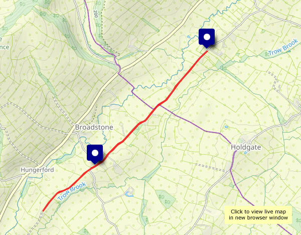
View OS map on Streetmap http://www.streetmap.co.uk/map?X=355025&Y=289695&A=Y&Z=120
We’re enjoying a very pleasant walk in the country below the Wenlock Edge. Our route takes us along along quiet lanes, which rise gently all the way to Plaish, before a steeper descent back to the start. The views are great; the low angle of the sun brings out the colours, which turn increasing towards a golden red as the sun gradually drops to the horizon. The days are very short now.


View OS map on Streetmap http://www.streetmap.co.uk/map.srf?X=353520&Y=295320&A=Y&Z=120
The usual short leg-stretch – and yes, it’s very pleasant, especially in the morning sunshine. There’s not a cloud in the sky! Not many leaves on the trees either, but the winter wheat (or barley) is greening the fields like velvet.


View OS map on Streetmap http://www.streetmap.co.uk/map?X=367515&Y=298310&A=Y&Z=120
The Tern’s flood plain is well filled today! ‘Lake’ is fair description of the temporary expanse of water, the outcome of Bert’s downpours and the rapid melting of snow. The ground’s rather soggy too, in places, but mostly the walking is good underfoot. Once again, we’re following a different route around the extensive parkland – the deer are out and about, and we won’t get a good view of them if we stay in the woods. We won’t be able to enjoy the sunshine there either.


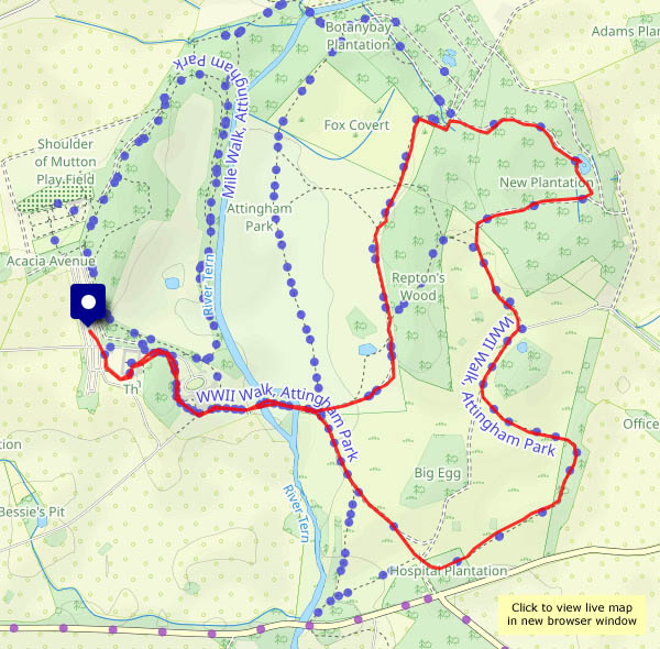
View OS map on Streetmap http://www.streetmap.co.uk/map?X=355180&Y=310120&A=Y&Z=120
The snow and the leaves… There are still a few little patches of white, but most of the ground is bare, and though a few leaves remain, the trees are mostly skeletal. Ten days ago, it was autumn around Willey; now it’s winter.


View OS map in Streetmap http://www.streetmap.co.uk/map.srf?X=367470&Y=298250&A=Y&Z=120
A less-exciting day today (can’t push my luck too often) – less snowy too. The white stuff is melting steadily in the sunshine – and we need the sunshine, as it’s still very cold in the shade. We’re walking along the lane past Hurst Farm pools, turning back when onward path passes into the shadow of the trees. It’s very pleasant up here – and fields are remarkably stripy today.


View OS map on Streetmap http://www.streetmap.co.uk/map?X=366865&Y=296250&A=Y&Z=115
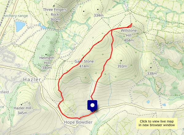
Wednesday 20 November: It’s icy cold out, but also dry and sunny, under a clear blue sky. To stay indoors would be unforgiveable! So we’re enjoying a short (and fairly slow) walk on the Hope Bowdler hills – over the main ridge to the Battle Stones, and back across the moor. It’s wonderful up here – the snow has drifted a little, carving some interesting shapes; it’s deep in places. The (invisible) path isn’t always easy, as we step in and out of the (deep!) few footprints left by others, but it’s fun! And there’s no-one else about – just one young woman descending with a dog, in the first half-mile. After that, the hills are ours for the afternoon!


")

View OS map on Streetmap http://www.streetmap.co.uk/map?X=348115&Y=293760&A=Y&Z=120
A Sunday morning along Shirlett Lane, making the most of a dry spell (there’ll be rain this afternoon). There’s even a little sunshine!


")


View OS map on Streetmap http://www.streetmap.co.uk/map?X=365920&Y=298080&A=Y&Z=120
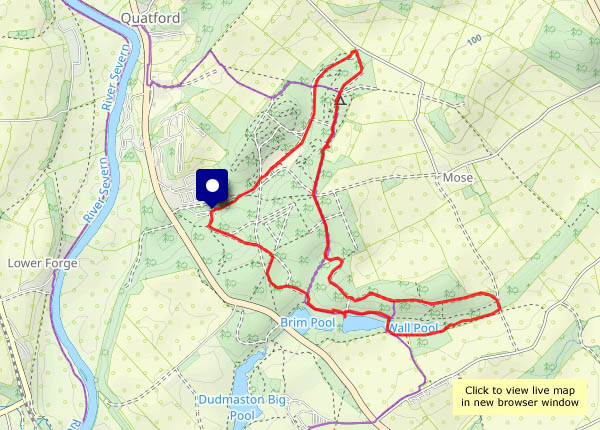
These golden days will soon be over – we’re making the most of the colours in Comer Woods. Everyone else seems to have had the same idea – there are lots of other people (and their dogs) out and about today. They seem to be getting further from their cars today too – perhaps they’re having to walk to keep warm. There’s plenty of room here though – much of the time, there’s no-one else in sight (or earshot!)


")


View OS map on Streetmap http://www.streetmap.co.uk/map?X=374735&Y=289590&A=Y&Z=120
