The Aqueduct

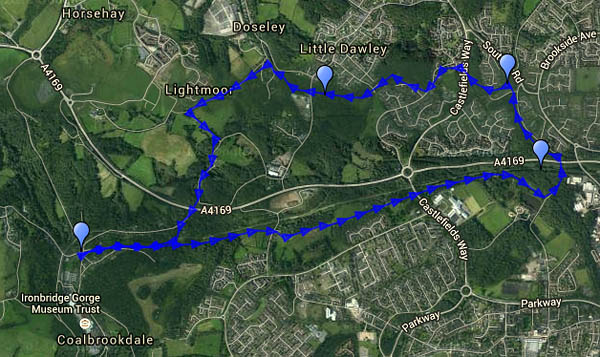
A district of Telford is named after the c1792 sandstone bridge built to carry the western branch of the Shropshire Canal over the turnpike road. Both are long redundant, but their courses remain. Though we’d driven through the area very many times, we’d never sought out the structure – perhaps we ought to go and have a look? Sadly, it’s in need of renovation, and much of it is hidden behind corrugated steel sheets. We walked there from the “coke hearth” at the top of Coalbrookdale, along the trackbed of a pre-railway age tramway, with beside us the railway which still carries fuel to the power station. We left this route where it was once crossed by the Coalport branch line, following the latter a short way to the aqueduct. Now our route would follow, on and off, the canal – to a point where it was crossed by a wagonway – another ancient bridge with a plaque to confirm the fact, though its construction date seems to be unknown. Whatever its age, it made an excellent spot to shelter from a sudden sharp flurry of snow… We returned to the car along rough lanes before descending once again to the wagonway beside the railway. Most of our walk had been on, or beside, ancient transport routes, mostly unseen and unknown by today’s road users.

Map
View OS map on Streetmap http://www.streetmap.co.uk/map.srf?X=367995&Y=305276&A=Y&Z=120

January on the Mynd

We’ve done it many times, always with subtle variations. The afternoon was too good to waste – leaving the car in the Carding Mill Valley, we walked up Townbrook Valley onto the ridge and on to Pole Bank. The air was growing cold as we headed back towards Mott’s Road; if we’d done this a month ago, it would have been dark by the time we got back to the car.

Map

View OS map on Streetmap http://www.streetmap.co.uk/map.srf?X=343320&Y=294676&A=Y&Z=120

Clee Murk

Thursday: there was a chance that the sun might break through later in the afternoon – it was trying when we left home. It failed – though sunbeams to the south showed success elsewhere. It was cold on Clee Hill, with patches of snow, and the views weren’t great – the hills beyond Ludlow more sensed than seen. It’s not pretty up here – a bleak landscape, with much evidence of past industrial activity. But it’s atmospheric today, and the old workings are interesting. We started out from Clee Hill village, past the noisy working quarry, and headed north-eastwards to Magpie Hill. Our return was by Random Farm and the three-forked pole (see http://www.geograph.org.uk/photo/607144), descending from Hoar Edge (and its frost…) to the Titterstone road. From the top of the old incline, we followed the route of the railway (more industrial evidence) back towards the car. An enjoyable afternoon.

MapView OS map on Streetmap http://www.streetmap.co.uk/map.srf?X=360005&Y=276536&A=Y&Z=120

Munslow Mud

Saturday afternoon: we’re out on the Wenlock Edge, enjoying some winter sunshine. There was a moderate sprinkling of snow at home – perhaps there would be a bit more up on the edge? No such luck – just an occasional dusting to prove we were in the same county. Sadly, one or two short stretches of the (public foot)path have been deeply churned by tractor tyres and are almost unwalkable. In fact they are unwalkable. The only progress that can be made – very cautious hedge-hanging, slithering and clambering out of one rut into another – cannot be described as walking. We’ve walked these same paths and tracks in previous winters, and one or two stretches can get a bit sticky, but now they’re seriously damaged. (Did the local farmer get a new tractor for Christmas? One of those really huge, heavy monsters that completely fill the lanes? I hope it came with a rut-filling attachment…)

Calm before…

…the high winds and heavy rain, forecast for tomorrow. It wasn’t completely calm today – there was a light breeze, and it was pleasant to be out in the country to the south of Shrewsbury. Lyth Hill is a tremendous viewpoint for the Shropshire hills – it’s also a popular spot for the dog-walkers. We left them behind as we descended towards Exfords Green, past the venison farm. By the time we got back to the car, the day was changing…

MapOr view OS map on Streetmap http://www.streetmap.co.uk/map.srf?X=346640&Y=306321&A=Y&Z=120

Winter sun

There was still evidence of Saturday’s snow showers on the Stretton hills. We should have been out enjoying the conditions on Sunday, or yesterday, but other transport arrangements got in the way. No such problems today, and once again, the sun was bright and the frost hard – the mud on the path to Hope Bowdler was well-frozen. It’s the walk we did in November (“To the Battlestones“), though today we started from the parking space below the Gaer Stone. Most enjoyable it was too!

Clear Skies over Clee Burf

A cloudless (almost) blue sky – bright sunshine, no wind and frost on the ground. Domestic duties will have to wait – we’re off to Clee Hill again, walking up to the radio mast (not quite a scenic highlight) on Clee Burf. The light becomes warm as the air grows colder, and we’re back to the car just minutes before sunset. It’s great to be out on afternoons like this.

MapOr view OS map on Streetmap http://www.streetmap.co.uk/map.srf?X=358500&Y=284901&A=Y&Z=120&ax=358625&ay=284851

Mist on the Chase

It was more like fog at home, and might be worse further west. We headed east instead, for a walk on Cannock Chase, from Milford to the visitor centre at Marquis Drive (tea, sausage rolls, cake – we try to live life to the full). Our outward route followed, roughly, the old railway trackbed – not so easy at the southern end of the walk. Returning, we made our way to the Sherbrook valley, retracing our steps only for the last half-mile down the cutting. As forecast, the day gradually brightened, and the sun began to break through towards the end of this very pleasant ten-mile trip.

Map

Or view OS map on Streetmap http://www.streetmap.co.uk/map.srf?X=398585&Y=317851&A=Y&Z=120

Another afternoon on the Mynd

Monday: the weather’s too good to stay indoors (and it can’t last) – we’re wandering on the Long Mynd, making the most of what little light there is in late November. The steep hillside path takes us quickly up into the sunshine, and by the time we’re coming back down Mott’s Road, it’s almost gone. Instead of the heavy clouds that shaded us yesterday, there’s lots of wispy cirrus, much of it forming from jet trails. And instead of that biting wind, there’s just a gentle breeze. Perfect!

Map

Or view OS map on Streetmap http://www.streetmap.co.uk/map.srf?X=343240&Y=294746&A=Y&Z=120

To the Battlestones

We did this walk, more or less, this time last year – more or less. Late November is good on the Hope Bowdler hills, or perhaps it’s the other way round. A stubborn bank of cloud limited the sunshine on the ridge, though there was plenty of sunlight in the distance, and the wind was biting, briefly carrying a light shower of rain (that wasn’t forecast!). We sheltered, more from the wind than the rain, behind the Gaerstone for a few minutes, before descending the last of the ridge as the sun dropped.

Map

Or view OS map on Streetmap http://www.streetmap.co.uk/map.srf?X=347350&Y=293596&A=Y&Z=120