Back to Rubha Hunish

Mon. 1st May: I’m on my own again, heading for Skye’s northernmost tip – Rubha Hunish. The path down the cliff face, between Meall Tuath and Meall Deas, puts many casual wanderers off. They’ve already reached a spectacular viewpoint, but the promontory below the cliffs is somewhere special. A cruise liner passes as I descend carefully: I’d much rather be where I am than where they are. There’s a great feeling of freedom on Rubha Hunish – I’d feel trapped inside that thing…

View OS map on Streetmap http://www.streetmap.co.uk/map.srf?X=141460&Y=875564&A=Y&Z=120

Glen Hinnisdal

Sun. 30 April: the circular walk that wasn’t… Glen Hinnisdal cuts deep into the Trotternish ridge, a few miles south of Uig. A surfaced road links scattered houses on the north side of the river; to the south, it’s paralleled by a well-graded and very walkable forest track. Much of the forest has been felled in recent years, though there is still some untouched woodland at the end of the track, just beyond the river crossing. If we follow one of the rides down through the forest, we can perhaps get across to the north side and walk back down the road. No chance! At first it’s just plain difficult, very wet under foot – but then we come to an area where trees have been blown across the gap, and now it’s impenetrable! We have to retrace our steps. A golden eagle flaps away from the tree tops yards from where we turn – wow, he’s big. I don’t think many walkers have been here recently.

The views are, of course, subtly different on the way back – instead of the ridge, we’re now facing the Waternish peninsula across Loch Snizort, with Macleod’s Tables beyond. We’ve come here to try to avoid the cold easterly breeze – and now the wind’s dropping, and there’s more blue in the sky. We may not have achieved what we’d intended, but it’s been very pleasant.

View OS map on Streetmap http://www.streetmap.co.uk/map.srf?X=141610&Y=858170&A=Y&Z=120

Loch Sneosdal

Sat. 29 April: I’m being left to my own devices this afternoon. I’m walking to Loch Sneosdal, a well-hidden lochan below dark crags, just two miles from the Quiraing as the golden eagle flies. For every thousand pairs of feet visiting the latter, I doubt if one visits Sneosdal. Other than the occupants of one or two cars on the main road (it’s very quiet, the views to Lewis and Harris are excellent, and it makes a good circular walk possible) I see no-one else. From the main road, the Heribusta lane is a pleasant stroll; from the top of the lane, a moorland track starts out towards the lochan. It becomes less distinct, before petering out altogether, and to reach to water’s edge is hard work. I make my way slowly and cautiously around the far shore, before following the feeder stream up towards the low grassy ridge. Now, after the somewhat closed-in amphitheatre of Sneosdal, I’ve got the views of the outer isles again – and can see my route ahead to the rough-surfaced waterworks road, which provides a quick route back to the start.

View OS map on Streetmap http://www.streetmap.co.uk/map.srf?X=140215&Y=869330&A=Y&Z=120

Dun Liath

Thurs. 27 April: Cold and grey – but dry. Yesterday’s walk was busy (in relative terms, of course); today, we won’t see anyone else as we walk these unfrequented grasslands on the east side of Skye’s Trotternish peninsula. They weren’t always so quiet – we’re visiting Dun Liath, a small stone-walled hillfort, with the curious chambered walls which seem to be a feature of these structures. We walk on (across difficult soggy ground) to Carn Liath, marked on the map as a “chambered cairn”. Hmm – it may have been once, but today it’s just a pile of stones. There’s further evidence of habitation in more-recently vacated ruins which we pass on our way back along the grassy ridge (easy walking now!) to the car at Camas Mor.

View OS map on Streetmap http://www.streetmap.co.uk/map.srf?X=136665&Y=869575&A=Y&Z=120

Quiraing

Weds. 26 April ctd: after lunch, we’ll drive round to Flodigarry, and have a walk up the path from Loch Langaig to the Quiraing. More precisely, we’ll walk to the path below the Quiraing – one of us wouldn’t be able to get up there, or back down again (it’s just a bit too exposed)… The route is surprisingly busy: the better-known way from the parking area at the top of the pass is almost always busy, but this path is becoming popular now. Deservedly so – the rock scenery is amazing! There’s nowhere else like it in the UK.

We try to pick out a different route for our return, but the conditions underfoot make it too difficult to recommend – deep spongy moss, thick heather, tussocky grass – it’s really hard work. We’d better follow the others back down to the car.

View OS map on Streetmap http://www.streetmap.co.uk/map.srf?X=145768&Y=869901&A=Y&Z=120

Black Rhadley

The beginning of April marks an eagerly-awaited turning point in the South Shropshire calendar – the Bog Centre opens up for the season. That fact (with its implied prospect of excellent cakes, scones etc.) was the clincher when I asked my friend where he thought we might go for today’s walk.

Before we can enjoy those refreshments, of course, we have to earn them, and we haven’t even had lunch yet. Black Rhadley, overlooking the river West Onny as it winds through the Linley Hall estates, should be a suitable spot. It was, too – extensive views in all directions, and wonderfully quiet – just the birds, and there’s that curlew again. Lunch over, we head northwards along the Stiperstones ridge, as far as the head of Perkins Beach, where we turn back toward The Bog for tea and Stiperscones.

View OS map in Streetmap http://www.streetmap.co.uk/map.srf?X=335620&Y=297406&A=Y&Z=120

A grey bank holiday

Best kind? After a rainy morning, the afternoon looked a little more promising, though there was never any sunshine, and we did feel the odd spot of rain. So there were no views to speak of, nor were there many people. A few at the YHA cafe at Coalport, perhaps, where we enjoyed a brief refreshment stop (tea and cake, of course), and one or two others beside the Severn as we headed back, but certainly not bank holiday crowds. Yes (answering my own question) – they probably are the best kind, when you don’t have to go to work in the morning.

Bright and breezy: Brown Clee

Cool, too, in the wind. The east side of the hill is in the lee, and the walk is very pleasant through the parkland, warm in the sunshine with views improving as we gain height. Boyne Water is twinkling as the breeze lifts wavelets; a little further on, we’re out on the ridge. Now we have extensive views to the west, but we’re in the wind, and we need to keep going. It buffets the camera as we stand at the highest point. Moments later, as we begin to descend, we’re sheltered and it’s a warm spring afternoon once more.

View OS map on Streetmap http://www.streetmap.co.uk/map.srf?X=359885&Y=285911&A=Y&Z=120

Unknown hills

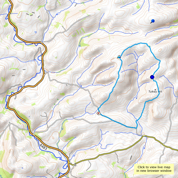
Can we find somewhere that will be quiet? With a clear blue sky and pleasantly-warm temperatures, the better-known destinations will be busy. But it’s quiet here. Really quiet! We’ve driven along the minor road between Llangunllo and Llanbadarn Fynydd, and parked at Moelfre City (which consists of two or three isolated farms). We’ve eaten our lunch, and walked back down the road for about a mile before taking the track into the hills. And we’ve seen no-one. Not a soul – until the chap turned up with a mower as we passed Cwmllechwedd Fawr. After that – no-one else, until we’ve completed the walk and driven homewards for several miles.

It’s quiet, not silent. We can hear larks (ascending, as they do), and occasional buzzards, and the odd sheep (aren’t they all?) makes its presence known, but that’s about it (there are one or two red kites too, never close enough for the camera). There’s a new wind farm up here, at Garreg Lwyd, just beyond the point where we turn back. If we listen carefully, we can just about hear the swish of the blades of the nearest turbine as they turn gracefully against the blue sky.

Our walk is taking us around the watershed of the Dildre brook. We pass the highest points of Tylcau, Newhouse and Warren hills on the outward walk, turn at Cae-glas Hill, and head back to the City via Tynybryniau Hill, Gors Lydan and Moelfre Hill. Gors Lydan is the highest point, at 528m (that’s 1,736′), but none of these hills have summits, in the sense of places worth visiting. I suspect the number of visitors they receive each year is in single figures – they’re unknown hills, and all the better for that on a day like today.

View OS map in Streetmap http://www.streetmap.co.uk/map.srf?X=313374&Y=276635&A=Y&Z=120