All Nations

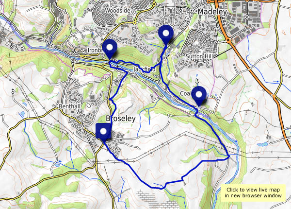
…is an old-fashioned little pub in Madeley. Just opposite the Blists Hill museum, it’s a bit of a time capsule in its own right, one of the last of the original home-brew pubs. Within walking distance too, not far off one of our regular routes. So instead of tea and cakes at Coalport, we’ll have lunch at the All Nations. Remarkably, it’s warm enough on this beautiful sunny day to sit outside (we’ll pay for it over the next few days…).
Suitably replete, we’ll follow a wonderful woodland way back to the “Free Bridge”, before rejoining our usual route homewards.

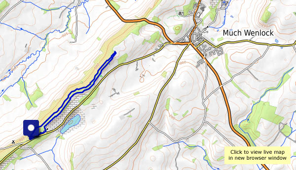
View OS map on Streetmap http://www.streetmap.co.uk/map.srf?X=369270&Y=301836&A=Y&Z=120

An Attingham autumn

Tuesday 9 October: an autumn wander around Attingham Park. The deer are busy with the rut (so we won’t disturb them), the leaves are turning nicely, and the squirrels are out in force making the most of the abundant nuts. There are some interesting fungi too (this is proving to be a recurring theme), though I’ve no idea what they are.

View OS map on Streetmap http://www.streetmap.co.uk/map.srf?X=355235&Y=309991&A=Y&Z=120

Walking in the gutter

Sunday 7 October: a walk from Stokesay to Aldon Gutter. There are valleys, dales, hollows and batches (and beaches – same thing) in this county. And gutters! They’re all valleys, one way or another; the only difference is perhaps their scale, and if that’s the case, then a gutter must be at the lower end – a fairly minor feature of our varied landscape. Today we’re walking from Stokesay to Aldon Gutter, for no better reason than (a) we’ve never been there before, and (b) it looked inviting on the OS map. It’s a very pleasant, and very quiet walk. The only people we see are the farmers at Aldon, moving their heifers indoors for the coming winter. Aldon Gutter (what a lovely place!) is thickly populated – with pheasants. There are hundreds of them, blissfully ignorant of their ultimate fate in the hands of so-called sportsmen – if, that is, they don’t stray onto the roads nearby.

Only one problem faces us. As we descend towards the Onny, with just a mile to go, the path fades to nothing (dense undergrowth in the woods). There’s no obvious way over the fence… Tricky! (We made it, of course, but a stile would have been good)

View OS map on Streetmap http://www.streetmap.co.uk/map.srf?X=343885&Y=279956&A=Y&Z=120

Cool and clear on Clee Burf

It didn’t seem to be especially clear (the Met Office had said “excellent” visibility), but we could make out Pen y Fan in the Brecon Beacons – and, faintly, the mountains to its west – that’s about 60 miles. It’s good up here when the air is cool and clear. There are interesting things close at hand too – fungi in profusion!

View OS map on Streetmap http://www.streetmap.co.uk/map.srf?X=358350&Y=284861&A=Y&Z=120

Mucklewick and Stiperstones

Thursday 13 September: a cool fresh day on Shropshire’s wild western fringe – this weather is great for a walk in these quiet (apart from the gunfire) hills. From The Bog, we’ll head for Mucklewick Hill (whose summit may be lower than our starting point), then down to Nind and up past the shooting range, where it sounds like they’re playing with their rocket-propelled grenades today. After a late lunch below The Rock (imaginative names in these parts), we’ll follow the ridge northwards, past the Devil’s Chair (he’s not sitting today, fortunately), before dropping back to the start, for tea and cakes at the Bog Centre (was the walking just an excuse?).

View OS map on Streetmap http://www.streetmap.co.uk/map.srf?X=335650&Y=297831&A=Y&Z=120

Distractions

Weds. 5 September: The London and North Western Railway used “Blackberry Black” paint on its locomotives – black with just a hint of colour. It’s probably that hint of colour in the fruits that makes them attractive to eat – a hint of something tasty, perhaps, and at present they’re ripe and juicy in great profusion in local hedgerows. They all had to be sampled, and as a result, we probably took a little longer walking around this enjoyable route on the quieter side of Much Wenlock. It’s not just blackberries that are fruiting – there are all kinds of fruits and berries ripening nicely, though we didn’t try nibbling the sloes or the crab apples, and certainly wouldn’t touch the toadstools. There were just a few sugar-sweet damsons within reach too…

View OS map on Streetmap http://www.streetmap.co.uk/map.srf?X=361355&Y=299046&A=Y&Z=120

Autumn’s Edge

An altogether different feel to today’s short outing – a walk along the Wenlock Edge, on a day when autumn feels as though it’s just around the corner. The air has a refreshing coolness, the leaves are on the cusp of changing colour, and there’s all manner of fruits and berries in the undergrowth. The blackberries are better than we expected during those hot days in June and July, causing some delay to our progress…

View OS map on Streetmap http://www.streetmap.co.uk/map.srf?X=359390&Y=298366&A=Y&Z=120

Sunshine and solitude

Sunday 19 August: At last, some decent weather. The clouds have cleared, no rain is forecast, the wind’s dropped. We’ve had a reminder in the past few days that Skye is full in August. There are huge numbers of visitors, who struggle with the single-track roads in the north of the island – especially those in hire cars, and as for all those monster camper vans… There are some very popular destinations up here, but if we avoid them, we should be OK. So we’re walking from Port Gobhlaig, along the very quiet coastal path to Rubha na h-Aiseig, and our companions will be the sheep and the seabirds. If the tip of this grassy promontory was a few yards further north, it would be the northernmost tip of Skye – and probably more popular. But wait – what’s this? As we walk back towards the start, there are two other people! How dare they? (Why are their voices so loud?)

Tomorrow we’re heading for home. Reminder to self: avoid high summer in future.

View OS map on Streetmap http://www.streetmap.co.uk/map.srf?X=143999&Y=875904&A=Y&Z=120

A grey day in Uig

Saturday 18 August: we’ve been on gardening duties all morning. This afternoon, we need to go down to Uig to pick up supplies – we could have a leg stretch too. It’s a grey afternoon, but the rain seems less likely. The waterfall on the river Rha is a good start, then we’ll follow the shore path to the river Conon – and walk up the road as far as the Fairy Glen. The once-quiet side road is now busy with visitors, who struggle to park when they reach their destination. On foot, we can simply enjoy the scenery.

View OS map on Streetmap http://www.streetmap.co.uk/map.srf?X=140105&Y=863575&A=Y&Z=120