Heath Chapel and Clee St. Margaret

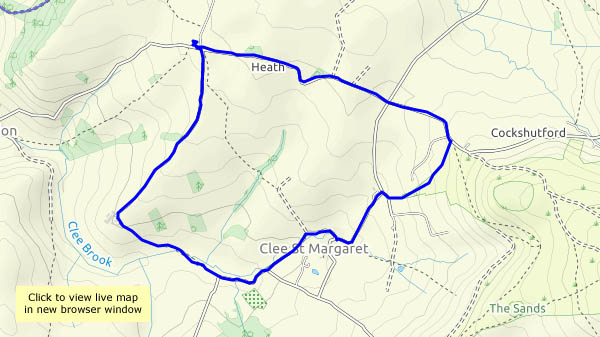
We’re on the western slopes of Brown Clee, starting out below the hill fort and walking down the lane as far as Heath Chapel, a remarkable (grade 1 listed) little building dating from Norman times. Leaving the chapel, we head for Peckledy (a farm), from where a tree-lined track aims towards Clee St. Margaret. Beside the lane there’s much buzzing – a wild bees’ nest, which appears to have been robbed recently (the evidence is on the ground a few feet away).
Clee St. Margaret is distinguished by its unusual ford, where the brook runs along the road – and around the bend – before continuing its journey down to Corvedale. Our journey continues gently uphill, across the grassland below Nordy Bank and back to the car.

View OS map on Streetmap http://www.streetmap.co.uk/map.srf?X=356225&Y=284720&A=Y&Z=120

Red kite and small blue

A walk along the very quiet road through Shirlett, down Ned’s Lane, through the Smithies and back up to Shirlett via Round Hill. There’s plenty to see as the season moves along – today’s highlight being the pair of red kites which circled above us briefly (a photographic failure!), followed by the small blue posing just a little further on. Meanwhile, the harvest continues.

View OS map on Streetmap http://www.streetmap.co.uk/map.srf?X=366240&Y=297950&A=Y&Z=120

The Wyke walk

This time yesterday it was almost 30°; today it’s barely over 20°. What a difference! The air feels cool, it’s still and humid – clammy in the shadier places – and we’d better not hang around, it’s going to rain later. The blackberries slowed us down significantly (we have to assess their quality for jam-making purposes), nevertheless, we were practically back to the start when the rain came on. One of these days, we’re going to get caught out – but not today!

View OS map on Streetmap http://www.streetmap.co.uk/map.srf?X=365265&Y=301021&A=Y&Z=120

Plaish

It’s a hamlet in the quiet country between the Wenlock Edge and the Stretton hills. It’s notable for its 16th century hall, apparently one of the earliest brick-built houses in the county. The views would be wonderful from its elevated position – but not today – it’s murky, and only just starting to feel warm as we return to the car. A very pleasant leg-stretch nevertheless.

View OS map on Streetmap http://www.streetmap.co.uk/map.srf?X=353520&Y=295320&A=Y&Z=120

Approaching autumn

An evening wander, up Ned’s Lane and back down past Round Hill. There are thick tangles of wild hops in the hedges beside the road, and some of the bindweed and bramble leaves are decidedly warm-toned. A few low-dangling damsons (I’m thinking of jam already!) have been tested by several fingers already, but the fact that they’re still there means they need a little more ripening. Soon…

View OS map on Streetmap http://www.streetmap.co.uk/map.srf?X=367107&Y=297480&A=Y&Z=115

Linley Brook and Stocking Lane

In January, we walked over Nordley Common and down to Linley Brook, where what should have been a pleasant path beside the stream was more like a jungle assault course. Perhaps in early August it will be fit to walk? Yes, it is – though still quite muddy in places, it’s more like the enjoyable amble we’d expected. Varying our route a little now, we stop to watch four sheepdogs, who clearly know what to do and how to do it (see the YouTube clip below).
Crossing the main road again, Stocking Lane takes us to a quiet field path leading over the hill and back down to the start.

View OS map on Streetmap https://www.streetmap.co.uk/map.srf?X=368150&Y=297381&A=Y&Z=120

Clockwise at Aldenham

A familiar route which we follow more frequently in the other direction. The weather forecast suggested the the showers would clear (they did!) but the sky would be heavy with cloud (those little dark grey symbols). Yes, that was true too – but with little gaps to let the sun through, spotlighting little details in the surrounding countryside.
The dragonfly (a black-tailed skimmer) was very good at flying off, further up the path through the barley, whenever I got almost close enough for a half-decent photo. They know, don’t they?

View OS map on Streetmap http://www.streetmap.co.uk/map.srf?X=366905&Y=295705&A=Y&Z=120