An evening wander along this very quiet lane, enjoying the low angle of the light and the lower temperature after a warm afternoon


View OS map on Streetmap http://www.streetmap.co.uk/map?X=365992&Y=298162&A=Y&Z=115

An evening wander along this very quiet lane, enjoying the low angle of the light and the lower temperature after a warm afternoon
View OS map on Streetmap http://www.streetmap.co.uk/map?X=365992&Y=298162&A=Y&Z=115
They’ll be shady, cool perhaps… In the still and humid air, any sunshine would be uncomfortable, but in the event we saw little of the sun, and it was certainly very pleasant under the trees on the eastern slopes of Brown Clee. Colourful too – great masses of rhododendron here and there. It’s Cosford air show today – we might see some of the flying exhibits? We did, but just one big thing that circled for a time, never getting quite close enough for a decent photo. We didn’t see (or hear) the Red Arrows either – perhaps we’re just too far away. We did see a red kite, which on balance is a preferable alternative… And other than one group of chatty walkers, we had the hill to ourselves.
What does it sound like up here? Listen!


View OS map on Streetmap http://www.streetmap.co.uk/map?X=359930&Y=286800&A=Y&Z=120
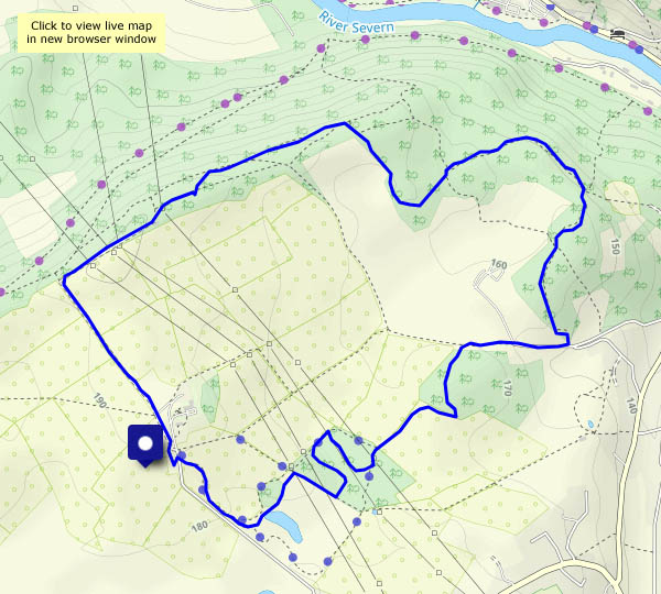
It will even warmer after lunch, so we’re out a little earlier today. We’re following our tracks from almost two weeks ago – up Round Hill, down Ned’s lane, over Nordley Common to Stocking Lane and back through sheepy fields. Same route, but the season has moved on.


View OS map on Streetmap http://www.streetmap.co.uk/map?X=367690&Y=297465&A=Y&Z=120
…and another amble past the barley fields and the Boldings pools


View OS map on Streetmap http://www.streetmap.co.uk/map?X=370945&Y=296885&A=Y&Z=120
But the photographer did! Perhaps 30 years ago, a late neighbour told me he’d found a bee orchid on Wenlock Edge. I’ve been watching out for them ever since. In May, the early purple orchids are plentiful; now, the common spotted abound (as we saw yesterday), and we’re approaching the pyramid season. We were hoping we might find some of the latter today. We did – just a few, they need a week or two more. Then – there it was! Just the one, in bloom and eye-catching – a most remarkable find, the first I’ve ever seen! Still buzzing…


View OS map on Streetmap http://www.streetmap.co.uk/map?X=359200&Y=298505&A=Y&Z=120
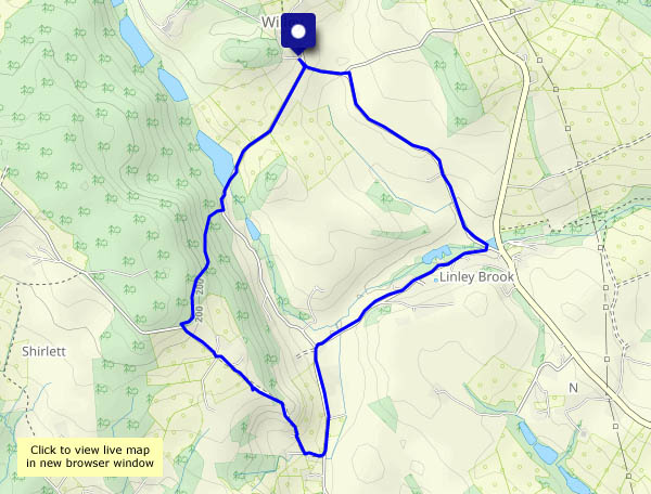
We were here on Sunday, and we’re back for another look at the orchids, followed by a stroll through the shady woods


View OS map on Streetmap http://www.streetmap.co.uk/map?X=366080&Y=302675&A=Y&Z=120
Monday 5 June: we’re walking with an old (as in “we’ve known her many years”) friend, from Black Pool car park, through the forest and up the gentle slopes of the common to High Vinnals. The top (with a perfectly-placed bench) is a wonderful viewpoint, even on a hazy day, though it won’t be if the trees get much taller…
Descending now, we’re following a fairly straight route to the old part of Richard’s Castle – there’s very little left of the castle itself, but the redundant St Bartholomew’s church next door is worth a look – and provides some pleasant shade on this sunny afternoon.
Like the village of Richard’s Castle, this walk straddles the county border – we start and end in Shropshire, but much of the forest, including High Vinnals, is in Herefordshire, as are (by a matter of yards) the castle and church.


 upright")


View OS map on Streetmap http://www.streetmap.co.uk/map?X=348435&Y=271455&A=Y&Z=120
The hedgerows are really colourful now, and the wild rose is blooming. Summer is here!


View OS map on Streetmap http://www.streetmap.co.uk/map?X=369245&Y=301430&A=Y&Z=120
We weren’t sure there would be many in bloom yet – but already there are hundreds, both in the scrubby woodland where they’ve been prolific for a few years, and in the beautiful buttercup meadows nearby. The orchids are our last objective this afternoon – much of our wandering has been in the pleasantly cool and shady woods along Benthall Edge.
We stopped at the usual chocolate seat in the woods, overlooking the old Patten’s Rock quarry and Ironbridge. I took the photo (below) but didn’t notice the deer (centre bottom – little more than a speck) until I studied the photo on the computer screen…


")


View OS map on Streetmap http://www.streetmap.co.uk/map?X=366080&Y=302675&A=Y&Z=120
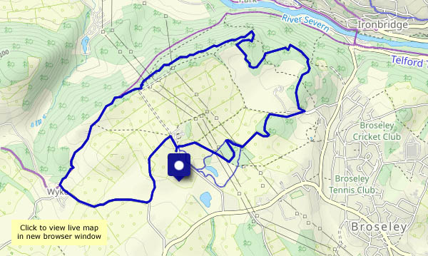
Lots of potatoes have been planted very recently in the fields around Willey. They’re not showing yet – there’s been no rain – so the clean-cut furrows are neat and pristine, revealing the rich red of the local soils. Beyond the spuds, we’re extending the route slightly – up Round Hill (where tiny damsons are already forming on the bushes) and back down Ned’s Lane. Everywhere is very quiet on this bright sunny afternoon.

")


View OS map on Streetmap http://www.streetmap.co.uk/map?X=367435&Y=297965&A=Y&Z=120
