Walking down to Coalport the long way, then, after ice creams at the youth hostel café, back up the Dingle – the short way home!


View OS map on Streetmap http://www.streetmap.co.uk/map?X=369245&Y=301430&A=Y&Z=120

Walking down to Coalport the long way, then, after ice creams at the youth hostel café, back up the Dingle – the short way home!
View OS map on Streetmap http://www.streetmap.co.uk/map?X=369245&Y=301430&A=Y&Z=120
More hedgerow colour on a bright afternoon. The damsons will soon be ripe (perhaps they are already – but they were out of reach…)


View OS map on Streetmap http://www.streetmap.co.uk/map?X=367515&Y=298310&A=Y&Z=120
An amble along Shirlett Lane on a showery afternoon. There are all kinds of interesting things coming up – I think autumn is going to be particularly fruitful this year…


View OS map on Streetmap http://www.streetmap.co.uk/map?X=366015&Y=298180&A=Y&Z=120
The wheat and barley, the damsons, the lords and ladies – and the wild raspberries. There were only three or four, and they’d been eaten before I could get a photo…


View OS map in Streetmap http://www.streetmap.co.uk/map.srf?X=367470&Y=298250&A=Y&Z=120
Up the lane to Harnage – and then it’s almost all paths and tracks in this interesting little area threaded by the surprisingly deep valley of Coundmoor Brook. The season’s first blackberries are ripening, there are fine apples near the ford and some good-sized puffballs beside the lane – reminders that, though it’s still July, autumn is little over a month away.


")


")


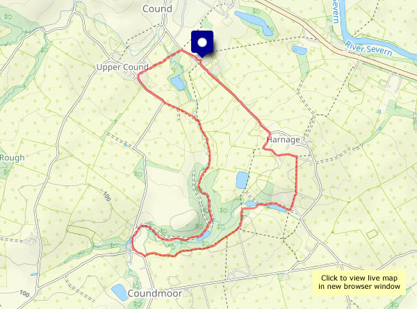
View OS map on Streetmap http://www.streetmap.co.uk/map?X=356010&Y=304105&A=Y&Z=120
Monday: just right for the walk up to Church Preen, along quiet lanes with great views. It’s a bit too breezy for the butterflies, though eventually a gatekeeper agrees to pose for us. Returning to the start, we’re looking out for a particular bush in the hedgerow, that had a good crop of wild gages a couple of years ago – ah yes, there it is. We’ll be back when they’re ripe!


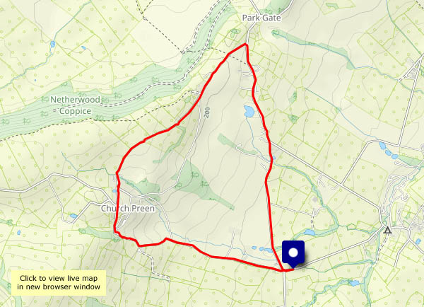
View OS map on Streetmap http://www.streetmap.co.uk/map?X=354910&Y=298575&A=Y&Z=120
Saturday evening: it’s windy around Willey, but it should stay dry for an hour or so. The sun shines only briefly, and up Bould Lane the hedgerow vegetation is blowing around. A little later, now in the lee of the Shirlett woodlands, it’s calmer. Down by Lower Pool, first a wren and then a goldfinch make their presence known (along with the inevitable canada goose and woodpigeon (click the ‘play’ button below), and there are grey wagtails hopping about by the water’s edge


View OS map on Streetmap http://www.streetmap.co.uk/map?X=367515&Y=298310&A=Y&Z=120
Saturday afternoon: a few minutes at this former lead mining centre in south-west Shropshire, one-time terminus of the Snailbeach District Railways. It’s a day of sharp, heavy showers – catching the sunshine in between is not easy…


View OS map on Streetmap http://www.streetmap.co.uk/map?X=337320&Y=302135&A=Y&Z=120
Another wander amongst the trees, on Haughmond Hill near Shrewsbury. There’s plenty of deciduous cover (chance of a shower…) as well as the inevitable conifers, and some great views over the Severn to the south Shropshire hills.


View OS map on Streetmap http://www.streetmap.co.uk/map?X=354395&Y=314075&A=Y&Z=120
Comer Woods – good tracks for walking when the field paths will be muddy (it’s been rather wet recently). At least it’s (mostly) dry today. The little froglets seem to like this weather – they’re hopping about all over the place, tiny little things barely half an inch across. We’ve really got to watch where we’re putting our feet!
Overhead, a blackcap (sometimes known as the ‘northern nightingale) and a chiffchaff politely take turns to entertain us (play sound file below).


 in Seggy Pool")
")


View OS map on Streetmap http://www.streetmap.co.uk/map?X=374780&Y=289595&A=Y&Z=120
