Back to Bannister’s

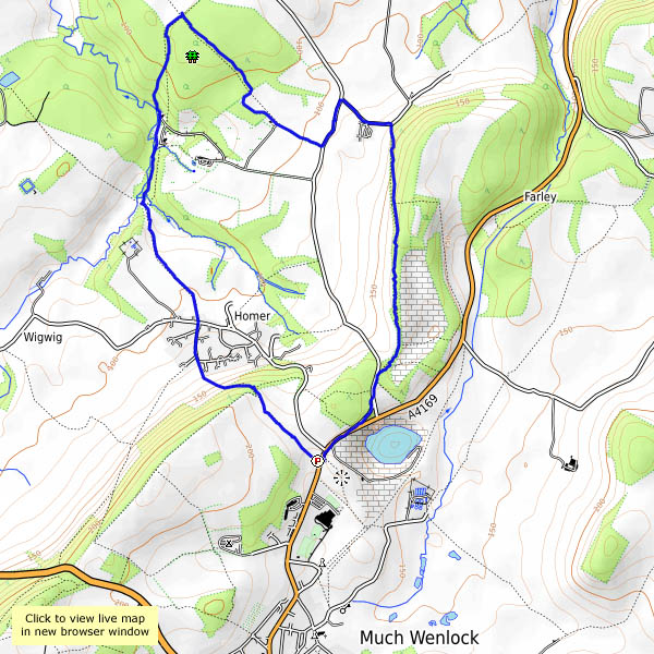
We walked to Bannister’s Coppice in the autumn, on a beautiful golden day; today’s dull and colourless, but I need a leg-stretch. Perhaps, like last time, I’ll see deer? Perhaps not. If nothing else, I can check the existence of a footpath, not shown on the OS map, which will avoid muddy fields on the return leg. Yes, it’s there, winding through the trees – the views are better too, looking back along the Wenlock Edge, with the village of Homer prominent in the middle distance. By now the afternoon is getting late – the light’s gone. Time for home.

map

View OS map on Streetmap http://www.streetmap.co.uk/map.srf?X=362505&Y=302021&A=Y&Z=120

December days on the Mynd

The days are really short now – just two weeks to the solstice. We’ll need to finish this walk before the sun sets – preferably an hour or so earlier, to give us time to enjoy the benefits of the tea room in the Carding Mill valley. It’s not cold today, though there’s a stiff breeze on top – it’s not easy holding the camera still for those long shots, but worth the effort (I think so, anyway) for those fading-distance views. To the south-west, the Black Mountains are anything but black – Pinky-Yellow Mountains? Perhaps not. Despite the breeze, it’s one of those afternoons when it would be good to stay up here indefinitely – but cake awaits! Come on!

map

View OS map on Streetmap http://www.streetmap.co.uk/map.srf?X=343505&Y=294981&A=Y&Z=120

Coalport on a grey afternoon…

…so we’ll do it in black and white! It’s a pleasant circuit, down to Jackfield by hidden paths in the jungle, then across to Coalport and along the old railway track to Coalport bridge. We cross the Severn again and walk along the other old railway, before joining Pound Lane and heading for home.

opentopomap.jpg

View OS map on Streetmap http://www.streetmap.co.uk/map.srf?X=369350&Y=301556&A=Y&Z=120

November on Clee Burf

There’s a stiff breeze, but it’s too good to stay in – we’ll walk up to Clee Burf, the southern summit of Brown Clee. Apart from the wind in the trees, it’s quiet up here. There’s no-one else about, apart from a solitary jogger, who doesn’t look happy. No shortage of sheep, of course. The forecast suggested there could be the odd shower, but we’re lucky today – bright sunshine throughout. There’s a big shower cloud to the north, and another, nearer, provides us with an unexpected rainbow. The end of it is just over there – no crocks though, just another sheep – taking on an appropriately golden tint in the late afternoon sunshine.

opentopomap.jpg

View OS map on Streetmap http://www.streetmap.co.uk/map.srf?X=358572&Y=284823&A=Y&Z=120

Wellington’s Hill

The Shropshire Hills AONB is almost entirely south of the Severn – just one little bit spills over to the other side, almost to Wellington, to encompass the Wrekin, which in many ways is Wellington’s own hill. The first stretch from the Forest Glen can be busy (that’s a relative term, of course), and the summit was positively heaving – there must have been four other people there, plus two dogs. Most visitors seem to turn here and return the way they’ve come. Beyond lie the rocks (notable for the Needle’s Eye, which one must thread at least once in a lifetime) – and a different feel altogether. That’s perhaps because of the views – the ground drops away sharply, and the panorama in the south-westerly quarter is spectacular, especially on an afternoon like this. Unusually, the strong directional sunshine lasted while I stayed on top – the clouds gathered as I returned along the quiet woodland paths on the north-western flank. Did a few snowflakes drift gently down, or was I imagining things? It was certainly cold enough.

opentopomap.jpg

View OS map on Streetmap http://www.streetmap.co.uk/map.srf?X=362970&Y=308326&A=Y&Z=120

Grandstand

The Hope Bowdler hills are not the highest  in Shropshire, but later in the afternoon, at this time of year, they provide one of the most spectacular viewpoints for the border country. Beyond the numerous ridges, picked out in the golden light, our south-western horizon is filled by the broad table of Radnor Forest. We have to feel sorry for all the others – those who weren’t up there. We only saw three people, and one of them, a runner, didn’t really seem to be paying much attention (What is this life if, full of care…). There are one or two showers about; happily, they pass us by. It’s not all good – there’s a biting breeze, and the temperature is dropping quickly as the sun nears the horizon. We’re almost glad to get back to the car.

opentopomap

View OS map on Streetmap http://www.streetmap.co.uk/map.srf?X=347585&Y=293626&A=Y&Z=120

Oh deer!

Wenlock to Bannister’s Coppice – out via Homer, back past Farley Hill and along the old railway track. The morning’s fog has cleared to hazy sunshine – it’s an afternoon to be out and about. The air is almost still, and though the woodlands are carpeted with the fallen, the trees are still well-covered with leaves, in widely varying shades of red and gold. There are usually deer about in these woods – today we enjoy no fewer than five sightings. In Bannister’s Coppice there are two, then two more, then a family of five, then a group of perhaps ten, out from the edge of the wood, tempted by the turnips in the field. Later, another two trot away from us on Farley Hill. These fallow deer are shy, often only partly visible for brief moments through the trees (and almost impossible to photograph). The turnip thieves are a real bonus, making this last day of October a little bit special.

View OS map on Streetmap http://www.streetmap.co.uk/map.srf?X=362115&Y=302131&A=Y&Z=120

Stiperstones in October

We’re walking the length of the ridge, from Snailbeach to the Rock, on a fine autumn day with the promise of some sunshine. The starting point is significant – one of our objectives is the Bog Centre for tea and cake – if we’d started there, it might have been closed by the time we returned (and that would never do!). So we’re heading out past Lordshill chapel and the Hollies, and two-thirds of the way around this very enjoyable route we come to the Bog, feeling suitably peckish. We return by the paths skirting Perkins Beach and Crowsnest Dingle, back to Snailbeach past that very fine octagonal chimney high up in the woods. And yes, after a dull start, the sun did shine, though it looked like we’d seen the last of it when we arrived back in Snailbeach. We hadn’t, of course – inevitably, it shone brightly while we drove home, floodlighting the autumn trees against a dark sky. Wonderful – but no photos.

View OS map on Streetmap http://www.streetmap.co.uk/idld.srf?X=336585&Y=299306&A=Y&Z=120&lm=1