Peaceful Portree

Wednesday 15 October: the summer is long past, but the centre of Skye’s ‘capital’ Portree is busy with tourists. That’s where I find myself, and I need to hang around for about 90 minutes on this cloudy but still afternoon. If I walk down to the end of Bayfield Road, I can continue around ‘The Lump’ – that should be quiet. It was, of course, but the photos may convey a false impression of the Portree that the visitors see…

View OS map on Streetmap http://www.streetmap.co.uk/map?X=148237&Y=843453&A=Y&Z=115

Chestnuts and toadstools

Perhaps Chestnut Coppice should be renamed Toadstool Wood? There are certainly lots of chestnuts – we left with our pockets full – but there’s also a fine crop of all kinds of fungi. Mushrooms? Toadstools? I’m no judge, I just enjoy finding them, in all their different shapes and sizes, ranging from single isolated specimens to large family groups. And I’d much rather leave them for everyone else to enjoy.
The fallen chestnuts are in a different category. We’ll roast them and enjoy eating them – and rest assured, there are plenty left for the squirrels and other nibblers of nuts…

View OS map on Streetmap http://www.streetmap.co.uk/map?X=372065&Y=296465&A=Y&Z=120

Sunny Mynd

Monday 6 October: What a beautiful afternoon! It would be a crime not to be out on the hills, though we can hardly call this Long Mynd wander a hill walk. We’ve parked the car at about 1530′, and the highest point, Pole Bank, is 1680′. A good leg stretch though, through the rich colours of the autumnal moorland. Returning to the start, we realise we’ve had the best of the sunshine – clouds are starting to gather – but it’s been really pleasant out on these hills

View OS map on Streetmap http://www.streetmap.co.uk/map?X=342385&Y=295030&A=Y&Z=120

Canalside at Newport

That’s Newport, Shropshire, not one of the several others around the UK… Newport was the first place of any size served by the canal which ran from Norbury Junction, on the Birmingham and Liverpool Junction canal in Staffordshire, to Shrewsbury, with connections into the tub boat canals in east Shropshire. It was abandoned in 1944; some stretches are still in water, but much has disappeared completely. The Shrewsbury & Newport Canals Trust, which aims to restore the canal, has been active for the last 25 years. A stretch of roughly 2km (about a mile and a third) is in water through Newport. Though not yet navigable (several locks have been walled up and filled in) a good canalside path provides for a very pleasant walk (popular, too, on this Sunday afternoon)

Wikipedia: Shrewsbury Canal

View OS map on Streetmap http://www.streetmap.co.uk/map?X=374530&Y=319530&A=Y&Z=120

Symmetry

Hadn’t realised until I looked at the map! There’s a certain symmetry about an out-and-back route in any case. Not that it has anything to do with the feel of the walk – a real “blow the cobwebs away” struggle against storm Amy, while the few clouds fly past, taking me from light to shade and back in seconds. No great height here, but there are sweeping views to the south – and it really catches the wind. I’m not hanging around!

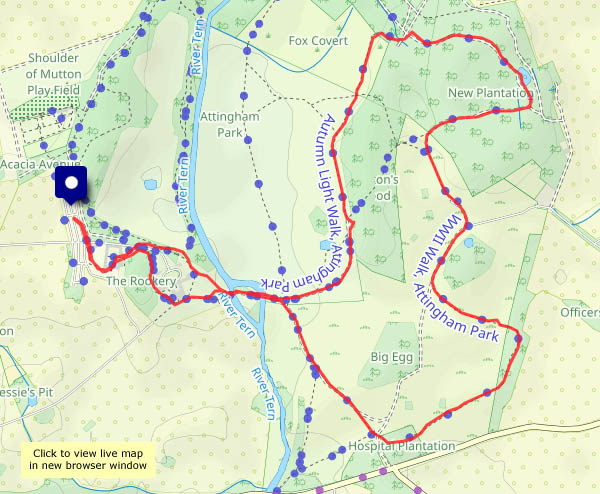
View OS map on Streetmap http://www.streetmap.co.uk/map?X=366750&Y=296360&A=Y&Z=120

Apple pressing day

A perfect day for it! For a number of years it’s been an annual event at the village hall. There’s no shortage of good fruit around here – this year the crops have been exceptional. It grieves me to see piles of rotting apples where no-one has bothered to pick them, but there are no such piles around Willey (and windfalls are not allowed access to the press). They’ve all been picked and are being chopped by the scratter and squeezed in the press. We’ve parked about a mile and a half away and walked here (the lanes are very narrow and parking could be tricky) so we’ve earned a drink and a piece of (delicious!) home-made cake, bought some local (Willey) honey and had a large bottle filled with golden juice. Something to enjoy over the next day or two…

View OS map on Streetmap http://www.streetmap.co.uk/map?X=367300&Y=297960&A=Y&Z=120