Toadstool time

Fungi in the forest (and chestnuts under the trees). It’s still wet underfoot, but the paths around Comer Woods are mostly mud-free and very walkable. There are lots of interesting fungi, though most seem to be of the same kind, and there are fallen chestnuts everywhere. The squirrels think it’s Christmas!

View OS map on Streetmap http://www.streetmap.co.uk/map?X=374885&Y=289885&A=Y&Z=120

A day for the hills

Sunday 15 October It’s bright and breezy today. The forecast thinks it will be dry and sunny all day – we really must head for the hills. The Bog Centre will be open – let’s head for the Stiperstones. The views are wonderful, and with the sun lower in the sky now, it’s atmospheric too. Perfect! Now for the tea and cakes!

View OS map on Streetmap http://www.streetmap.co.uk/map?X=336360&Y=298305&A=Y&Z=120

Repeat performance?

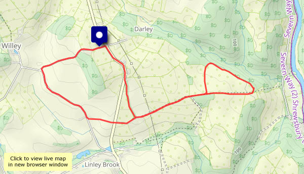
About four weeks ago – just before we set off on our trip to the north – I had a very pleasant wander through the fields between Bould Lane and the river (see ‘Run for it!‘). I met three fallow deer, two of which were an unusual dark colour, found a tree very heavily laden with crab apples (perfect for jelly, but I had no means of carrying them), then found my way blocked by a fallen tree. What will I find today? I’ll take a bag…

There were two deer away across the other side of the lower field, by Birch Wood – two of the three I saw last time, I’d guess. They’ve spotted me. Then came the tree – almost all the apples had gone, though I was still able to pick a reasonable quantity (I need much longer arms). The blocked path? No change there! As I retraced my earlier steps, I watched a red kite quartering the far edge of the fields, by the wood. Not a repeat performance, but would I want that? An enjoyable afternoon!

Vies OS map on Streetmap http://www.streetmap.co.uk/map?X=368755&Y=298755&A=Y&Z=120

Walking in reverse – the Skye Trail

Skye, 4 October It starts at the (possibly well-known) phone box at the Shulista road end, and heads for the cliffs of Meall Tuath, high above Rubha Hunish – Skye’s northernmost point. It then swings south-eastwards, skirting the rim of spectacular cliffs before cutting across a grassy ridge to arrive at the old Balmaqueen churchyard (and continue  down through Trotternish and the Cuillins to Broadford, some 128km in total). I’m starting at Balmaqueen, walking the first three or four miles of the trail in reverse to arrive at the phone box. To complete this circular walk I’ll walk back along the road – not a part of the trail, but it’s no great hardship.

I only realised this path had been created when I studied the OpenStreetMap (see below). We’re setting out on the long journey home in the morning: almost literally, along the clifftops, I’m going out on a high!

View OS map on Streetmap http://www.streetmap.co.uk/map?X=142359&Y=875513&A=Y&Z=120

North-east coastal wanderings

North-east Scotland, 1 October It’s over 80 miles, as the crow flies, from Inverness to Fraserburgh, where the north-facing coast swings around to face the east. We’re exploring roughly midway, a 15-mile stretch between Buckie and Macduff with interesting coastal scenery and a variety of ports and harbours, from the large commercial facilities at each end to the photogenic little gem of Portsoy. Not to mention the Cullen skink* at Findochty…

*Smoked haddock soup!

View OS map on Streetmap http://www.streetmap.co.uk/map?X=355300&Y=864325&A=Y&Z=130