Rubha na h-Aiseig again

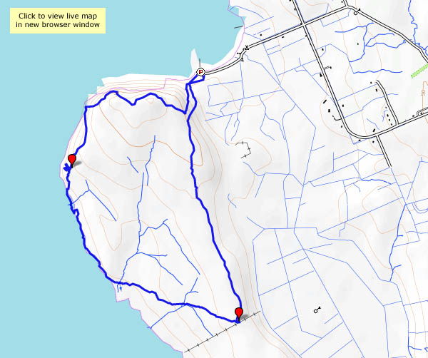
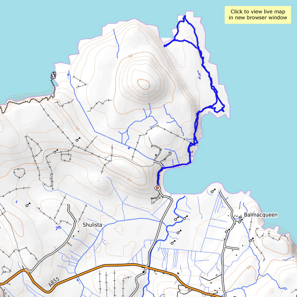
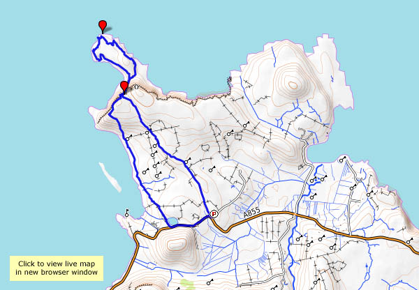
Tues. 2 May: we’ve walked this way several times before, but it’s always an enjoyable outing. From the tiny Port Gobhlaig, a faint path follows the top of low cliffs, with stacks and inlets and an excellent view to the coast and hills to the south. After a little while, what seems to be an ancient path descends steeply to the grassy foreshore, fringed by rocks, pools and camels (just their humps). Eventually, one can go no further. There’s evidence of settlement here, the remains of perhaps three “black” houses by the shore – is this where a ferry (to Trodday, just a mile off shore) once departed? It’s a pleasant, and exceptionally quiet spot – there’s no-one else here – a good place to find a comfortable rock seat and gaze across the water. Eventually, we return the way we’ve come, more-or-less, which is no hardship given the views of the cliffs and Trotternish ridge ahead.


View OS map on Streetmap http://www.streetmap.co.uk/map.srf?X=144015&Y=875895&A=Y&Z=120

Back to Rubha Hunish

Mon. 1st May: I’m on my own again, heading for Skye’s northernmost tip – Rubha Hunish. The path down the cliff face, between Meall Tuath and Meall Deas, puts many casual wanderers off. They’ve already reached a spectacular viewpoint, but the promontory below the cliffs is somewhere special. A cruise liner passes as I descend carefully: I’d much rather be where I am than where they are. There’s a great feeling of freedom on Rubha Hunish – I’d feel trapped inside that thing…

View OS map on Streetmap http://www.streetmap.co.uk/map.srf?X=141460&Y=875564&A=Y&Z=120

Glen Hinnisdal

Sun. 30 April: the circular walk that wasn’t… Glen Hinnisdal cuts deep into the Trotternish ridge, a few miles south of Uig. A surfaced road links scattered houses on the north side of the river; to the south, it’s paralleled by a well-graded and very walkable forest track. Much of the forest has been felled in recent years, though there is still some untouched woodland at the end of the track, just beyond the river crossing. If we follow one of the rides down through the forest, we can perhaps get across to the north side and walk back down the road. No chance! At first it’s just plain difficult, very wet under foot – but then we come to an area where trees have been blown across the gap, and now it’s impenetrable! We have to retrace our steps. A golden eagle flaps away from the tree tops yards from where we turn – wow, he’s big. I don’t think many walkers have been here recently.

The views are, of course, subtly different on the way back – instead of the ridge, we’re now facing the Waternish peninsula across Loch Snizort, with Macleod’s Tables beyond. We’ve come here to try to avoid the cold easterly breeze – and now the wind’s dropping, and there’s more blue in the sky. We may not have achieved what we’d intended, but it’s been very pleasant.

View OS map on Streetmap http://www.streetmap.co.uk/map.srf?X=141610&Y=858170&A=Y&Z=120

Loch Sneosdal

Sat. 29 April: I’m being left to my own devices this afternoon. I’m walking to Loch Sneosdal, a well-hidden lochan below dark crags, just two miles from the Quiraing as the golden eagle flies. For every thousand pairs of feet visiting the latter, I doubt if one visits Sneosdal. Other than the occupants of one or two cars on the main road (it’s very quiet, the views to Lewis and Harris are excellent, and it makes a good circular walk possible) I see no-one else. From the main road, the Heribusta lane is a pleasant stroll; from the top of the lane, a moorland track starts out towards the lochan. It becomes less distinct, before petering out altogether, and to reach to water’s edge is hard work. I make my way slowly and cautiously around the far shore, before following the feeder stream up towards the low grassy ridge. Now, after the somewhat closed-in amphitheatre of Sneosdal, I’ve got the views of the outer isles again – and can see my route ahead to the rough-surfaced waterworks road, which provides a quick route back to the start.

View OS map on Streetmap http://www.streetmap.co.uk/map.srf?X=140215&Y=869330&A=Y&Z=120

Dun Liath

Thurs. 27 April: Cold and grey – but dry. Yesterday’s walk was busy (in relative terms, of course); today, we won’t see anyone else as we walk these unfrequented grasslands on the east side of Skye’s Trotternish peninsula. They weren’t always so quiet – we’re visiting Dun Liath, a small stone-walled hillfort, with the curious chambered walls which seem to be a feature of these structures. We walk on (across difficult soggy ground) to Carn Liath, marked on the map as a “chambered cairn”. Hmm – it may have been once, but today it’s just a pile of stones. There’s further evidence of habitation in more-recently vacated ruins which we pass on our way back along the grassy ridge (easy walking now!) to the car at Camas Mor.

View OS map on Streetmap http://www.streetmap.co.uk/map.srf?X=136665&Y=869575&A=Y&Z=120

Quiraing

Weds. 26 April ctd: after lunch, we’ll drive round to Flodigarry, and have a walk up the path from Loch Langaig to the Quiraing. More precisely, we’ll walk to the path below the Quiraing – one of us wouldn’t be able to get up there, or back down again (it’s just a bit too exposed)… The route is surprisingly busy: the better-known way from the parking area at the top of the pass is almost always busy, but this path is becoming popular now. Deservedly so – the rock scenery is amazing! There’s nowhere else like it in the UK.

We try to pick out a different route for our return, but the conditions underfoot make it too difficult to recommend – deep spongy moss, thick heather, tussocky grass – it’s really hard work. We’d better follow the others back down to the car.

View OS map on Streetmap http://www.streetmap.co.uk/map.srf?X=145768&Y=869901&A=Y&Z=120

Fruit and nut

Mon 24 April: we’re heading north, towards an overnight stay in Glen Devon. We’re slightly ahead of schedule – let’s have a look at this pineapple thing… It’s quite startling, and definitely strange – a huge carved stone pineapple, at the head of a walled garden not far from the south bank of the Forth, a few miles east of Stirling. Other than the pineapple, and the walls (three of them), and a little pool, there’s nothing else and no-one else there. (There are further grounds to explore, but on this day of sunshine and snow showers, it’s too cold to hang around for long)

The Pineapple NT Scotland

Black Rhadley

The beginning of April marks an eagerly-awaited turning point in the South Shropshire calendar – the Bog Centre opens up for the season. That fact (with its implied prospect of excellent cakes, scones etc.) was the clincher when I asked my friend where he thought we might go for today’s walk.

Before we can enjoy those refreshments, of course, we have to earn them, and we haven’t even had lunch yet. Black Rhadley, overlooking the river West Onny as it winds through the Linley Hall estates, should be a suitable spot. It was, too – extensive views in all directions, and wonderfully quiet – just the birds, and there’s that curlew again. Lunch over, we head northwards along the Stiperstones ridge, as far as the head of Perkins Beach, where we turn back toward The Bog for tea and Stiperscones.

View OS map in Streetmap http://www.streetmap.co.uk/map.srf?X=335620&Y=297406&A=Y&Z=120