Attingham’s always good

It certainly was on this fine and sunny afternoon. It’s almost four miles around the perimeter of the park, and there’s plenty of interest en route. The sticky horse chestnut buds are swelling and bursting, there are deer in the park, a chaffinch is enjoying some sunflower seeds (and posing for the camera) and the ducks are having fun in their pond. Can’t go wrong on an afternoon like this!

View OS map on Streetmap http://www.streetmap.co.uk/map?X=355120&Y=310060&A=Y&Z=120

Over the Edge: Westwoods

Not far from Wenlock – Stretton Westwood and Bourton Westwood, a few houses and a large farm respectively. There’s not a cloud in the sky – it would be criminal not to be out enjoying the quiet countryside on a day like this. Starting from the old quarry beside the Church Stretton road, we head up the farm track and over the Edge, descend to the field path past Bourton Westwood, and return to the start down the lane and through the old quarry. This is the lesser-known edge at this end of the double escarpment – there’s no-one else about. What a pleasant little outing!

View OS map on Streetmap http://www.streetmap.co.uk/map?X=360205&Y=297680&A=Y&Z=120

Violets and yellowhammers

It’s not quite the walk we’d intended. The bluebell wood path is blocked (we’ll take the detour, along the edge of the field), then further on Workhouse Coppice is, in effect, closed – both due to fallen trees. We’ll retrace our steps a little way and head for Benthall Edge woods, where there’s no problem. We’re entertained along the way by numerous songbirds – the usual suspects plus, on this occasion, a chiffchaff or two, and last of all a yellowhammer. He’d love some bread, but isn’t too struck on cheese, apparently.


Chiffchaff, robin, wren, thrush, wood pigeon, blue tit, yellowhammer…

View OS map on Streetmap http://www.streetmap.co.uk/map?X=366070&Y=302595&A=Y&Z=120

Nordley Common and Stocking Lane

Last time I tried to walk through the sheep pastures up here, about 15 months ago, the mud did its best to stop me. I suspect it’s been quite muddy ever since, but the recent dry weather made it worth a retry. Yes, soft in places but not a problem. On this fine morning – the vernal equinox, no less – it’s very pleasant up here, and (dare we say it?) comfortably warm. No hats, scarves, gloves, thick winter jackets today!

View OS map on Streetmap http://www.streetmap.co.uk/map?X=368065&Y=297340&A=Y&Z=120

A sense of space

Aston Munslow: a walk up to the Wenlock Edge, the crest of which is over 1,000′ in these parts. It clearly catches the wind – December’s storm Darragh has done some damage. We’ll have to revise our route. Diversions notwithstanding, this is a great place to be on a fine and sunny afternoon. The views across Corvedale are extensive, taking in the Clee hills and Mortimer Forest, beyond Ludlow. There’s a real sense of space up here – and we’ve got it all to ourselves!

View OS map on Streetmap http://www.streetmap.co.uk/map?X=351190&Y=287735&A=Y&Z=120

A study in scarlet

We last walked this way back in July, when the Wenlock Edge was a colourful place to be (see The colour of July). It’s not quite as colourful in mid-March, though the occasional patch of primroses brightens things up. Then a few spots of bright red catch the eye – a fine display of elf cups on a rotting log. Almost back to the start, there’s a very different fungal growth (not quite as eye-catching) – a cluster of black blobs – none other than King Alfred’s cakes.

View OS map on Streetmap http://www.streetmap.co.uk/map?X=359435&Y=298335&A=Y&Z=120

Black Isle

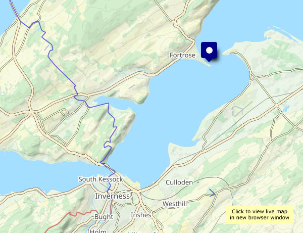
Mon 10 March: Homeward bound – we’ll be on the 20.45 train from Inverness tonight, and we really don’t want to miss it. We’ve a hire car to drop off too. It’s a fair distance from the north of Skye to Inverness – about 140 miles – let’s get close to Inverness and then we don’t need to worry about time. The result is, of course, that we’ve time to kill – we’ll visit Chanonry Point, that remarkable shingle spit at Fortrose on the Black Isle.

Chanonry is noted for spotting dolphins and the like, but casual visits don’t usually yield results. It’s an interesting place though – perhaps a mile distant across this narrowing of the Moray Firth is Fort George. To the south-west Inverness is barely visible in the haze, though the Kessock Bridge is prominent when it catches the light. Soon we’ll cross it, leave the car and explore the Inverness riverside before retiring to a suitable place for refreshment – and appropriately the Black Isle Bar, with its splendid pizzas and excellent beer, proves perfect for an hour or two, before the last few steps to the station, the train and the overnight ride home.

View OS map on Streetmap http://u.osmfr.org/m/1189278/

Balmacqueen: white waves, black rocks

There’s sufficient breeze to make white waves on the black rocks of Balmacqueen, and the sun’s doing much better today… I’ve walked this way several times, but it never fails to please, with a fine rocky foreground and extensive views. To the east are the mountains of mainland Scotland; to the north-west are the rugged hills of Lewis. Between them is open sea – next stop (well over the horizon!) the North Pole…

View OS map on Streetmap http://www.streetmap.co.uk/map?X=144323&Y=874438&A=Y&Z=120