The value of variety

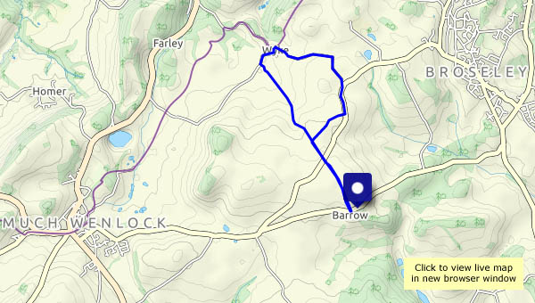
We walked this way little more than two weeks ago, when the weather had been damp. Today’s dry and sunny – quite different. That sums up the route too – each short stretch is quite different from the others. We start beside, and through, fields of ripe wheat. The next field is sheepy, then there’s the leafy way to Barrow and its ancient little church. A march down the road is unavoidable, before we leave it for pine woods, to walk past Wildwoods and up the sunken lane, then descend beside the estate wall to Willey. Willey is certainly “different”, medieval in appearance. Next, a very quiet narrow road leads us to Lower Pool, then up Ned’s Lane we go, to finish along Shirlett Lane, with its wooded stretches and some open views to Brown Clee and the Wrekin. Most enjoyable – never a dull moment!

View OS map on Streetmap http://streetmap.co.uk/map.srf?X=366190&Y=298996&A=Y&Z=120

Astley Abbots and Colemore Green

It was an enjoyable afternoon wander, though the photography was somewhat limited. I’d remembered the camera, but its battery and memory card were still in the charger and card reader at home. Spare battery? It was flat. Spare memory card? In the other camera bag. I’ll have to use the phone camera. As expected, there were few other people around, and those we met were all on the old railway track or the riverside path.

View OS map on Streetmap http://www.streetmap.co.uk/map.srf?X=370980&Y=297385&A=Y&Z=120


Flora and fauna

We’re sitting in the chocolate seat, enjoying a couple of minutes rest. “Look, there’s a rabbit” “No, it’s a hare!” Inevitably, he’s long gone by the time the camera is pointing in the right direction. Some of the butterflies are more obliging, and there are electric-blue damselflies on a branch in Shore Pool. A few poppies in the wheat catch the eye – as does a huge toast-coloured toadstool. An enjoyable afternoon outing!

View OS map on Streetmap http://www.streetmap.co.uk/map.srf?X=366905&Y=295705&A=Y&Z=120

Three hills…

… in the distance. The Wrekin, Brown Clee and Titterstone Clee – all are in view (from time to time) as we wander along the lane at Shirlett. Last time, we walked in a misty drizzle, and had to focus on things close at hand. The walnuts, the cherries and the cattle (and many trees!) are still here, and there’s an interesting but scruffy-looking toadstool beside the road. And it’s quiet – really quiet. As we pause at the top of Ned’s Lane, before heading back, there’s one small bird singing, a little way off. Not another sound!

The estate road and the terrace

A day on Brown Clee: the weather’s not great – gloomy, cold and just the occasional spot of drizzle – but it’s good to be out on Shropshire’s highest hill. Not a giant, Brown Clee is nevertheless a good viewpoint, and today the air is clear despite the gloom. Higher hills in Wales form a wonderful western panorama – and that summit away in the far south-west must be Carmarthen Fan, a full 100 km distant (just over 62 miles, but it sounds more impressive in metric). Our outward route has taken us along the estate road, then up the steep track to a bench beside Boyne Water. Later, after crossing the summit ridge, we drop down to the hillside terrace, with its views of Corvedale and the Wenlock Edge. A most enjoyable circuit!

View OS map on Streetmap http://www.streetmap.co.uk/map.srf?X=359765&Y=285845&A=Y&Z=120

Quiet? Not quite

This is a very peaceful part of the country, but it’s not at all quiet today. It sounds like a major gun battle is in progress in Shirlett woods. Eventually it’s over (perhaps they’re all dead) – and we realise there are four walkers following behind us. We don’t need to look around – we can hear them talking loudly, more then 100 yards away. Fortunately, at the top of Ned’s lane they go the other way. It’s still not quiet – in the field there’s one of those mammoth tractors (you could make a dozen little grey Fergies out of one) at work making hay. We can’t describe it as quiet. Happily, as we drop down from Round Hill, sanity returns. Almost. There are a couple of young women with a party balloon. Inevitably, it bursts loudly. Back to the car – time for home.

View OS map on Streetmap http://www.streetmap.co.uk/map.srf?X=367490&Y=297955&A=Y&Z=120

Hughley and Church Preen

It’s a dry day, after three rather wet ones. Away from good surfaces, it will be muddy, so we’re wandering along the lanes between Hughley and Church Preen. That would have been “quiet lanes…”, but there seemed to be much coming and going around the camp sites near Hughley, where the number of other walkers was almost into double figures. They didn’t seem to venture very far – there’s no-one else out on foot for the rest of the way round. There are good views of the Wenlock Edge and the Wrekin, and from the higher ground, to the Clee Hills. On the ridge near Church Preen, there’s a clear view to the Berwyn mountains in north Wales. An enjoyable little circuit!

View OS map on Streetmap http://www.streetmap.co.uk/map.srf?X=355325&Y=298465&A=Y&Z=120