Balmacqueen and Connista

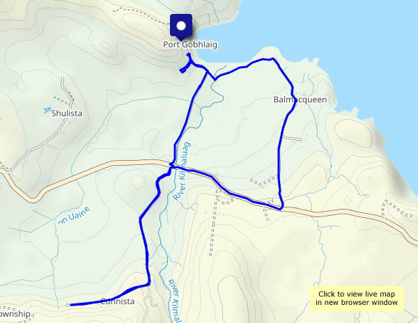
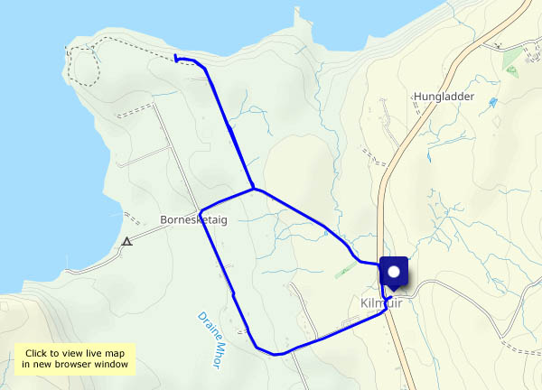
23 May (Skye continued): There are still plenty of showers around, but the afternoon looks like staying dry. We’ll take the waterproofs, just in case. We’ve walked from the small parking space at Port Gobhlaig many times, but we’ve never explored the lane from Kilmaluag to Connista – let’s try it! We’ll head along the path by the shore to Balmacqueen, then up to the main road and down to the bridge over the Kilmaluag River, whose clear peaty water looks like diluted Guinness… It’s a there-and-back-again walk to Connista – a very quiet one, with wonderful views. And no, we didn’t need the waterproofs.

View OS map on Streetmap http://www.streetmap.co.uk/map?X=143339&Y=874333&A=Y&Z=120

Rainy day

22 May: A wet day. Will there be any let-up? The window below sums it up nicely – apart from a few minutes around 6pm, when the rain stops. Light streams through the clouds to illuminate the settlement of Geary, beyond the Ascrib islands, around eight miles away across (sea) Loch Snizort. The little promontory at Oans is visible most days, but it doesn’t stand out – you wouldn’t know it was there. For a few minutes, the light falling through the rain brings Oans into sharp relief. Then the rain returns. Tomorrow will be better, won’t it?

View OS map on Streetmap http://www.streetmap.co.uk/map?X=127519&Y=860678&A=Y&Z=120

Borgh na Sgiotaig

20 May: That’s its Gaelic name. In English, it’s Bornaskitaig. Yes, we’re at our northern office, for just over a week on Skye. We haven’t chosen a very good week – a rainy spell seems to have arrived with us. The evening looks like staying dry, though there are showers around. We’ll park at the village hall, and wander around the quiet lanes through to the cliff top above Lùb an Sgòir (Score Bay…). The shadows are lengthening, and the clouds looking ominous as we head back towards the car.

View OS map on Streetmap http://www.streetmap.co.uk/map?X=138160&Y=870845&A=Y&Z=120

A dozen on a damp afternoon

It’s not actually raining, but there are spots in the breeze from time to time. We’re walking around Colemore Green – starting out near the old Astley Abbotts school, past Boldings Pools, down through Chestnut Coppice to the old railway track, then back up to the little wayside shop (we’re out of marmalade!). Under a grey sky, today’s interest is in the detail.

View OS map on Streetmap http://www.streetmap.co.uk/map?X=371135&Y=296950&A=Y&Z=120

Shugborough

Thursday 12 May: Staffordshire – a walk from the Satnall Hills car park, near Milford, through the Shugborough estate to find draught Bass in Great Haywood (no, it doesn’t look like rain! The weather’s better than expected too!). We return beside a tranquil stretch of the Staffordshire and Worcestershire canal to complete a circuit full of interest.

View OS map on Streetmap http://www.streetmap.co.uk/map?X=398720&Y=321695&A=Y&Z=120