It may have been hazy – no wonderful views of the Welsh heights – but it was very pleasant on this warm early-September afternoon. Quiet too – just three other people. The heather is still in bloom; the gorse is yellow, there are red rowan berries galore. What more can one ask? (An ice cream van at the top maybe? Perish the thought!)
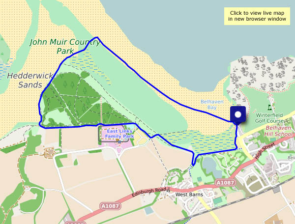
Friday 26 August: A shoreline walk to the west of Dunbar. The route I’ve shown on the map starts and ends at the “Bridge to Nowhere”, where there’s space for parking (I walked there…). It’s very nearly high tide and the bridge isn’t usable yet, the approach paths on either side are under water. Instead, I’ll follow the John Muir Way as far as the bridge over the Hedderwick Burn. I won’t cross it – I’ll walk along the shore around Hedderwick Hill plantation (which may need replanting after the devastation of last winter’s storm). Crossing the dunes brings me back to the beach, which is quiet at first, becoming more popular as I head back towards the bridge to nowhere. Happily, the tide has begun to ebb and I can cross without getting wet feet. I may need to hurry along a bit now – the sky’s looking rather threatening – are those the first drops of rain?
There are oystercatchers and curlews in the creeks and marshes, and on the beach are smaller birds (I think they’re sanderlings), skittering about trying to retrieve tasty morsels without getting wet. They’re never still for a moment, which makes getting a decent photo tricky…
Needed it! I spent most of yesterday travelling, a 300-mile journey entirely by public transport (plus a couple of short walks). The day’s passing quickly – I’d better get on with it! A short circular’s sufficient to clear away the cobwebs.
Thurs. 25 August: We’re spending a few days in Dunbar, on the north-east coast of Scotland, where the Firth of Forth has become the North Sea. By the time we’ve arrived and settled, there’s only enough daylight left for a quick walk along the clifftop paths. It doesn’t look as though the sun will shine – I won’t take a camera… Inevitably, the unexpected sunset was well worth a photo or two – I’ll use the phone.
Before we can wander anywhere, we must visit the bookshop – we need to top up, and it’s raining! It wasn’t supposed to; it was just a shower and soon past. The season is moving rapidly – it’s clearly a good year for hops, most of the crops have been harvested, and there’s no shortage of hedgerow fruits
There are a few mostly light showers around this afternoon – spots in the wind as we set out, better carry the waterproofs… Inevitably, it stays dry until, perhaps 2/3 of the way round, we stop for chocolate – there’s a very convenient bench, with an excellent view, in Holdgate churchyard. More than just a few spots? We’ll have a look inside the ancient church (it’s well worth a look), and when we leave, the rain has gone (and the ground is dry – it can’t have been much). A little further down the lane, there’s a wonderful patch of blackberries – some of the biggest we’ve seen growing wild, and plenty of them. We’d have been home earlier, and hungrier, if they’d not been there…
Down through Chestnut Coppice to the trackbed, south towards Bridgnorth, then back along the riverbank and up the side valley to Colemore Green. A very pleasant outing on a bright and breezy afternoon!
We’re at the far end of Wenlock Edge, wandering down the lane to Westhope (where the blackberries are truly splendid), and onward to the foot of Flounder’s Folly. We’re not going up to the tower today – the highest point of the Wenlock Edge is a wonderful viewpoint, but not ideal for a good circular walk. Instead, we’ll walk back to the start through the woodlands along the western edge. With a steep drop through the trees to our left, and pleasantly open woods to our right, it’s an enjoyable walk – and interesting things lurk in the undergrowth…
What better place, on a grey day! Comer Woods have become popular – there are quite a few other cars parked. Woodland is very absorbent however – we pass just three other people on our four-mile circuit. Towards the end of the walk, when the path nears the main road, there’s some traffic noise – otherwise, there’s just birdsong, an odd light aircraft – and the occasional tooting and chuffing of trains on the Severn Valley Railway, out of sight but well within earshot. We like Comer Woods!
A little over a week ago, we were seeking the shade along Shirlett Lane – and found helleborines growing beside the road through the trees. Today it’s much cooler – 15C – and we’ve had a good drop of rain overnight and into the morning. It’s only just stopped – every now and then the trees shiver and sprinkle us with cold drops! The helleborines are past their best now, but worth another look.


")


")


")


")
")


")


")


")


