Town and Country

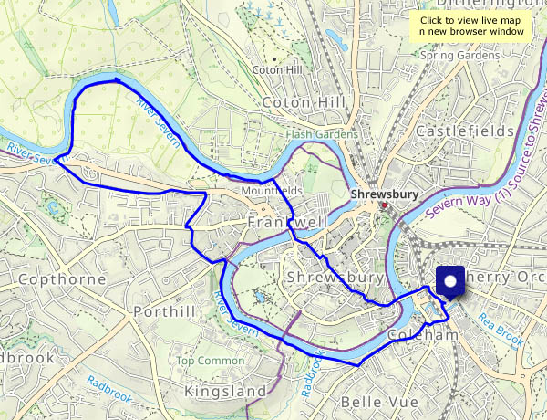
Shrewsbury’s riverside, heading upstream (after a walk through the town itself) along a stretch that, though close to civilisation, feels much more rural. We return, after threading suburban streets, past the school and the boathouses, with views across the river to towers of St Chad’s and the market hall. A pleasant, interesting and varied wander.

View OS map on Streetmap http://www.streetmap.co.uk/map?X=348455&Y=312770&A=Y&Z=120


Round Hill, Shirlett and Hurst Farm

An enjoyable circular, making the most of the current dry conditions – the route passes through fields which can be rather soggy at this time of year. The land between Shirlett and Hannigan’s Farm feels particularly remote – no sign or sound of habitation. I don’t think it gets many visitors (and I’m not complaining!).

View OS map on Streetmap http://www.streetmap.co.uk/map?X=366520&Y=296945&A=Y&Z=120

Munslow skyscapes

Tuesday 7 February: There was a mist in Corvedale as we descended from the Rushbury road, but by the time we were parked and walking, it was merely a haze. The sky was clear blue, with just a tick of high, white feathery cloud – which gradually grew to provide with a remarkable skyscape as the sun neared the horizon. The deer were a bonus – we tried, but they weren’t for hanging around once they’d seen us…

View OS map on Streetmap http://www.streetmap.co.uk/map?X=350995&Y=287750&A=Y&Z=120

Croft Ambrey and Bircher

An old favourite… It does what favourites should – it’s a very enjoyable walk from start to finish. There’s woodland and open grassland, with wonderful views in most directions (though not all at the same time…). Below the hill fort at Croft Ambrey, the old Scots pines provide foreground interest to some of the most attractive scenery in this part of the world, where the Herefordshire hills meet the Welsh border country. To the south-west, the Black Mountains and the Brecon Beacons form a distant horizon, where Pen y Fan could be mistaken for a dormant volcano (it isn’t!). It’s another fine day too, the sunshine warm for a time. What more could one want?

View OS map on Streetmap http://www.streetmap.co.uk/map?X=345190&Y=266450&A=Y&Z=120

A long thin walk…

…on Wenlock Edge. It’s not very long – just under four miles. Thin? A glance at the map reveals all. Our return route parallels our outward route, but outwards we’re in the woods below the Edge, and returning we’re on the Edge – there are views! There’s barely any sunshine today – until the last few minutes when the sun lights the fields on the eastern Edge, with Brown Clee for a backdrop

View OS map on Streetmap http://www.streetmap.co.uk/map?X=359200&Y=298505&A=Y&Z=120

Highlanders and a goldcrest

They come in brown and black – the hielan coos, that is. The sheep are all black too. The goldcrest was an unexpected treat (sorry, no photos – he was never still for more than a second, but a pleasure to watch – and then a van came down the lane and frightened him away). A very pleasant wander around Much Wenlock, on an end-of-January afternoon that felt springlike (we’ll pay for it in February, I’m sure)

View OS map on Streetmap http://www.streetmap.co.uk/map?X=361625&Y=300175&A=Y&Z=120

To Birch Wood

Same start as yesterday, but heading towards the river. Towards the eastern end of the route, the path follows the edge of Birch Wood, which hides a steep drop down into the valley of Dean Brook (we won’t go there…). The path forms a T-junction with a bridleway from Linley to the Severn – I’ll turn right and head past Linley’s old church and across the field to Bould Lane, taking me back to the start.

View OS map on Streetmap http://www.streetmap.co.uk/map?X=368700&Y=298920&A=Y&Z=120