Borderlands

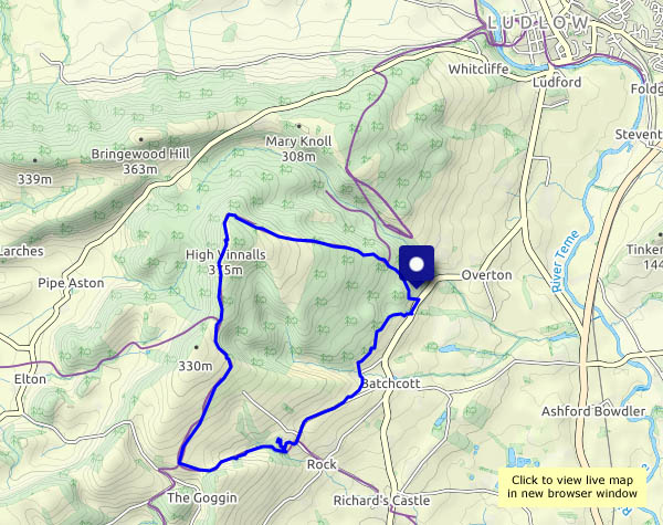
From Black Pool car park, up through the forest to High Vinnals, then out across the top of Hanway Common and down to Richard’s Castle (or what’s left of it), partly in Shropshire and part in Herefordshire. We walked this way about 18 months ago, on a fine, bright spring day (see “High Vinnals and Richard’s Castle“). Today’s a fine, bright autumn day, and it’s good to be out once more on these hills. High Vinnals is no great height (375m / 1230ft) but it’s a wonderful viewpoint, offering a tremendous panorama of the Welsh border country.

View OS map on Streetmap http://www.streetmap.co.uk/map.srf?X=348480&Y=271266&A=Y&Z=120

Spring in autumn

The harvest has taken the barley that was growing in these fields. The land has been ploughed, harrowed and re-sown – and next year’s wheat or barley (hard to tell at this stage) is starting to come up. There’s the green sheen of spring in this early autumn landscape! In the hedgerows, the season is more obvious.

View OS map on Streetmap https://www.streetmap.co.uk/map.srf?X=367540&Y=298191&A=Y&Z=120

Stretton Westwood

We walked this way two months ago, trying some new (to us) paths on the Wenlock Edge, just a couple of miles from Much Wenlock, We’re extending the route a little today, which adds distance but not much more interest. It’s a hazy day; despite the clear blue sky and sunshine, July’s colours are long gone, and the autumn leaves are still mostly ahead of us. Nevertheless, it’s good to be out – infinitely more enjoyable than long drives down busy motorways…

View OS map on Streetmap http://www.streetmap.co.uk/map.srf?X=360205&Y=297700&A=Y&Z=120


Bridge to nowhere

Landmarks local to Dunbar, where we’ve been for a few days: the bridge at Belhaven is useful when the tide is out… In the distance (about 6.5 miles / 10km) is the Bass Rock, home to an astonishing number of gannets.

We arrived home this afternoon, after a drive of over 300 miles, so that will have to do for now. More photos tomorrow.